What went wrong with Indonesia’s tsunami early warning system
Indonesia’s system, completed in 2008, consists of seismographic sensors, buoys, tidal gauges and GPS. None of these measures were able to adequately predict the scale of Friday’s tsunami, which reached heights of 20 feet in the city of Palu, south of the earthquake’s epicenter.
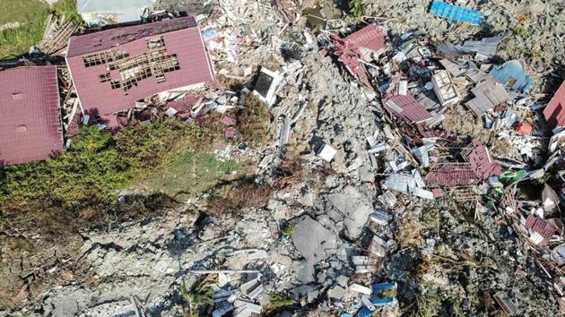
In the aftermath of the Friday earthquake and ensuing tsunami that destroyed thousands of homes and killed more than 1,200 people on the island of Sulawesi in Indonesia, officials are beginning to sort out what went wrong with the country’s early warning system for tsunami detection.

Indonesia’s system, completed in 2008, consists of seismographic sensors, buoys, tidal gauges and GPS. None of these measures were able to adequately predict the scale of Friday’s tsunami, which reached heights of 20 feet in the city of Palu, south of the earthquake’s epicenter.
Other shortfalls of the warning system in Sulawesi may have contributed to the tsunami’s toll. Some criticism centers on the lack of sirens to warn residents of oncoming waves and shelters on higher ground to accommodate evacuees. Despite the risk of frequent tsunamis up and down the Sulawesi coast, little of this infrastructure exists in Palu.
“We really need to emphasize that the earthquake is the warning. If the shaking lasts at least 20 seconds, get to high ground,” said Dr. Jason Patton, a geophysicist who works for Temblor, a consulting firm, and teaches at Humboldt State University in California.
WHERE THE TSUNAMI WARNING SYSTEM BROKE DOWN
Seismographic modelling
Seismographic sensors are designed to record an earthquake and determine its location and strength. Depending on its severity, the national meteorology, climatology and geophysics agency issues a potential tsunami warning using text messages and sirens.
— What happened
Earthquake hit at 6:03 pm local time.
Seismographic sensors relayed the detection of an earthquake with a magnitude of 7.5, meeting the threshold to trigger a tsunami warning.
An early standby warning was issued predicting a tsunami of 0.5 to three meters and telling people to evacuate.
Three waves of tsunami hit the coast from 6:10 p.m. to 6:18 p.m.
— What went wrong
The system isn’t perfect. The western coast of Sulawesi has experienced a tsunami from tremors that fell below the warning threshold before.
In this case, cellphone towers in the area had already been destroyed in the earthquake and people did not receive the text message alerts. There were no sirens along parts of the beach in Palu.
Network of buoys
Indonesia’s buoy network uses the floating devices to record changes in the sea level in deep water to confirm the existence of a tsunami. The buoys send a signal to a data center, which alerts the national meteorological agency, which in turn informs local authorities.
— What happened
No data was received from the buoys because none of them were operational.
— What went wrong
Indonesia has 22 open water tsunami buoys that have not worked since 2012 because of vandalism and lack of maintenance.
Tidal gauges
Tidal gauges, placed close to shore, measure changes in sea level every 15 minutes and send the data to the national meteorological agency.
— What happened
When the tsunami hit, the nearest tidal gauge to Palu, 125 miles away, recorded just a 2.3-inch rise in water levels.
Based on tidal gauge data and a field observation report from a staff member in Palu, the Indonesian meteorological agency lifted its tsunami warning at 6:36 p.m., about a half-hour after the original alert and after all three tsunami waves had hit.
— What went wrong
Tsunami waves grow in height and slow down as they approach shore and the water gets shallow. There was no data observation equipment near enough to Palu to measure tidal changes in the immediate area.
Tsunamis in Sulawesi tend to happen soon after earthquakes, leaving little time for tidal gauges set at 15-minute intervals to register them before they come ashore. After Friday’s earthquake struck, all three tsunami waves hit the area fewer than 11 minutes later.


