E-Paper



Number Theory: Constructions, sensitive ecology — More than rain at fault for Kerala landslides
In Wayanad, locals say that the major reason for the (landslide) disaster is the land use change as many marshy places and wetlands have been filled up.

 Prefer HTon Google


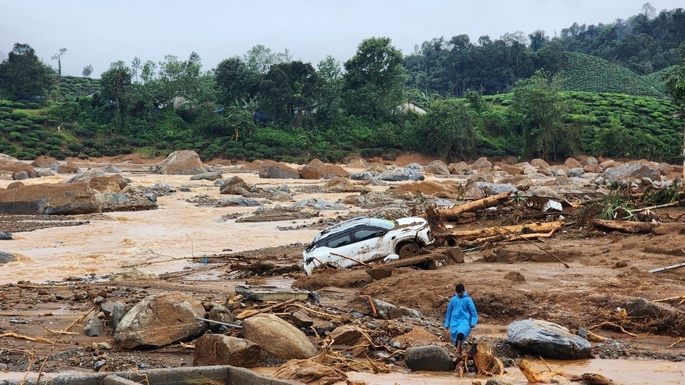
At least 135 people died due to a massive landslide in Wayanad district in Kerala. While multiple parts of Kerala witnessed floods and landslides on July 30, Wayanad became the epicentre of mass casualties on the day. What explains this? The immediate trigger appears to be intense rainfall. However, Wayanad was not the rainiest place in Kerala on the day. It is the landslides resulting from the rain that killed people. This is where the district is especially vulnerable. Wayanad is one of the most exposed districts to landslides in India, a fact that has been pointed out in multiple government reports. Yet, the number of settlements appear to have increased in the past 10 years, and also in the very area where disaster struck Tuesday. Here are three charts that explain this in detail.
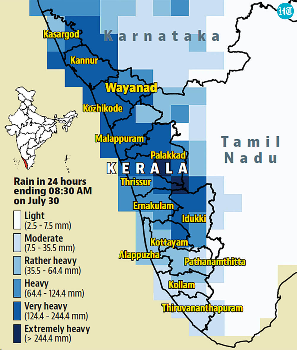
 Most districts in Kerala witnessed high intensity rainfall on July 30According to the gridded data of the India Meteorological Department (IMD), most of Kerala witnessed high intensity rainfall in the 24 hours ending 8:30 AM on July 30, the latest period for which gridded data is available. The intensity was particularly high in the northern half of the state. Parts of all districts up to Palakkad received rain between 124.5-244.4 mm, classified as “very heavy” by the IMD. This is the reason multiple parts of Kerala reported floods and landslides on July 30. For example, the part of Wayanad where deaths took place received 209.6 mm rain, which is also very heavy rain. To be sure, the most intense rain did not fall over Wayanad, from where most deaths and injuries were reported. The most intense rain took place at the southern border of Palakkad and Thrissur (262 mm) and at the northern border of Palakkad and Idukki (249 mm). Rain above 244.4 mm is classified as “extremely heavy” by the IMD. This shows that the intensity of rain alone is not the reason for the deaths in Wayanad.
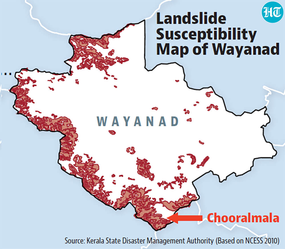
- But Wayanad is also highly susceptible and exposed to landslides…The deaths in Wayand took place because of the landslide triggered by the rain. This is where the district is extremely vulnerable. According to a landslide hazard map of the Wayand district, prepared for a 2019 report of the Jawaharlal Nehru Tropical Botanic Garden and Research Institute — it was submitted to the Kerala State Biodiversity Board (KSBB) — 26% of the state falls under high and very high-risk zones. This includes the Chooralmala and Meppadi part of the district where the disaster took place. This can also be seen in the accompanying map of landslide susceptibility in the district created by the National Centre for Earth Science Studies (NCESS) in 2010. It should, therefore, not be surprising that rain triggered landslides in the district. To be sure, susceptibility to landslides does not necessarily lead to deaths. This happens when landslides happen in populated regions. Kerala, especially Wayanad, is extremely vulnerable on this count as well. A February 2023 report published by the Indian Space Research Organisation (ISRO) adjusted susceptibility of landslides with the combined exposure of population, households, road, and livestock to the disaster. This shows that Wayanad was ranked 13th most exposed among the 147 hilly districts analysed in the report. To be sure, Wayanad is not the only Kerala district exposed to the disaster or the most exposed in the state. 13 of the state’s 14 districts – all except Alappuzha – are ranked in the top 50; and seven are ranked in the top 20. Thrissur, Palakkad, and Malappuram, and Kozhikode are ranked third, fifth, seventh, and tenth. The disaster in Wayanad should, therefore, serve as a warning to the entire state.
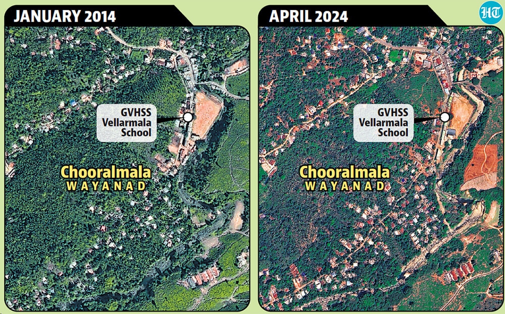
- But construction continues apace despite such warningsReports suggest that a prominent site of deaths in Wayanad on July 30 was the GVHSS school in Chooral Mala, which was functioning as a relief camp for flood affected people. Satellite images from Google Earth show that the area has seen an expansion in built-up area in the past ten years. Such expansion has been allowed despite the realisation that it could increase vulnerability to landslides. “In Wayanad the local people say that the major reason for the (landslide) disaster is the land use change; many marshy places and wetlands have been filled up”, another 2018 report by KSBB had noted. Such warnings about the fragility of Kerala’s and entire Western Ghat’s eco-system are not new. For example, ecologist Madhav Gadgil has repeatedly pointed to construction making the Western Ghats prone to landslides. Gadgil was the chairman of a Western Ghats Ecology Expert Panel, which had recommended 75% of Western Ghats to be declared environmentally sensitive in 2011. The panel’s recommendations were not implemented and all major political parties are opposed to implementing its recommendations.