
 E-Paper



Heatwave grips states, IMD predicts a warmer summer
Some regions are facing heatwave already; experts say the number of such days early on in the year is now increasing.

 Prefer HTon Google


Even as parts of the country experience a heat wave, the India Meteorological Department has warned that maximum temperatures in most parts of India will be above normal between April and June.

“We are seeing the heat wave being recorded in a very large area covering east, central and northwest India in March. It’s quite early this year. In the past 10 years we have seen heat waves occurring in April ; they used to start mainly in May before that. But this time, very high temperatures have been recorded in March also. This is mainly because of lack of rainfall, very dry air which gets heated quickly, clear skies and direct sunshine,” said K Sathi Devi, head, national weather forecasting centre.
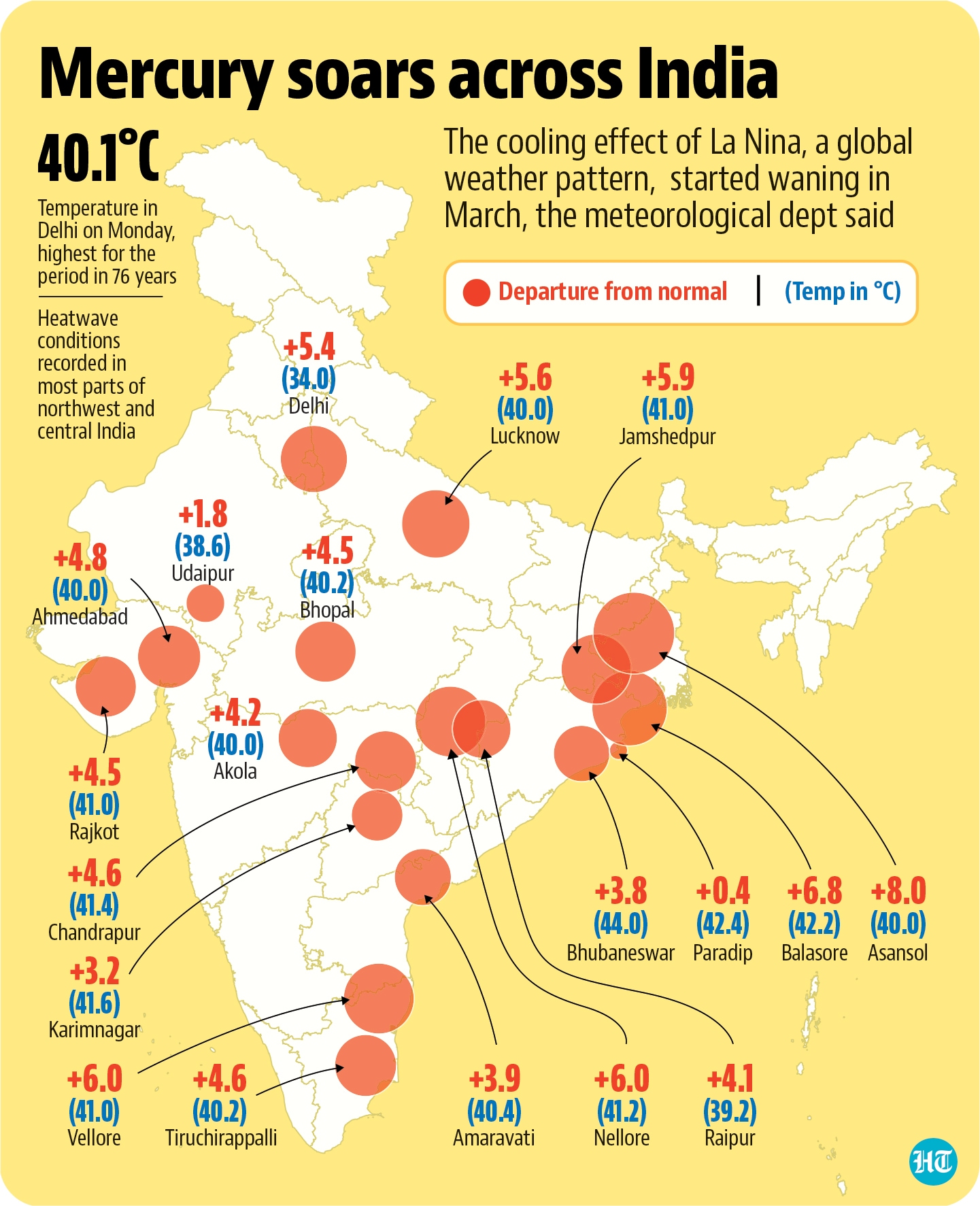
But the condition would abate in two to three days, she added, on account of “strong westerly winds.” Indeed, Wednesday was a relatively pleasant day in Delhi, with a maximum temperature of 37.9 degrees Celsius, 6 degrees above normal. But on Monday, March 29, the maximum temperature in the Capital touched 40.1 degrees Celsius (CHECK), the highest in 76 years.
IMD also said on Wednesday that above normal maximum or day temperatures (0.37 to 0.62 degree C above normal) are likely over most of the subdivisions of north, northwest and few subdivisions of east central India during the following three months (April to June).
Below normal day temperatures (0.16 to 0.44 degree C below normal) are likely only in some parts of Peninsular India, east, northeast and extreme north India, it added.
Above normal minimum or night temperatures are likely over few subdivisions along the west coast and west India. However, below normal season averaged minimum temperatures are likely over few subdivisions of northwest, central, east and extreme north India.
On Wednesday, heat wave conditions were recorded in most parts of northwest and central India with severe heat wave conditions in isolated pockets over West Rajasthan.
Temperatures in excess of 40 degrees C were recorded in many parts of Vidarbha, Maharashtra, East Uttar Pradesh, West Madhya Pradesh, Jharkhand and Odisha; in some parts of West Rajasthan, Saurashtra, Kutch, Chhattisgarh, East Madhya Pradesh ; and in a few parts of East Rajasthan, West Uttar Pradesh, Gangetic West Bengal, Gujarat region, Madhya Maharashtra, Marathwada, Telangana, North Interior Karnataka, Rayalaseema and Tamil Nadu.
Also read | Sizzler of a March turns out to be the hottest in 11 years, says IMD
The highest maximum temperature recorded on Tuesday was 44.6 degrees C at Baripada in Odisha. Bhubaneshwar recorded the highest temperature of 44 degrees C on Wednesday.
Maximum temperatures are likely to fall by 2-4 degrees C over most parts of northwest and central India during the next few days, IMD said in its bulletin. Strong surface winds (speed reaching 30-40 kmph) are likely to blow over parts of Punjab, Rajasthan, Haryana, Chandigarh, Delhi, Uttar Pradesh, Madhya Pradesh during next 48 hours, it added.
But there’s no denying that the heat wave is early, experts said.
“This year heat wave conditions have set in quite early. “There were hardly any western disturbances in January and February. In March there was an intense western disturbance but we still have a large deficiency,” said Kuldeep Shrivastava, head, regional weather forecasting centre.
Western disturbances are cyclones originating in the Mediterranean that bring colder temperatures and, sometimes, rains, to parts of India.
And the heat is likely to continue.
There is a high probability (60 to 100%) of above normal maximum temperatures over most subdivisions of north, northwest and few subdivisions of east central India (Jharkhand, Chhattisgarh and Odisha), IMD said on Wednesday. There is also a 50 to 100% probability of most subdivisions of Peninsular India; few subdivisions of east (Gangetic West Bengal), northeast (Sikkim and Sub Himalayan West Bengal and Assam and extreme north India (J&K and Ladakh) experiencing below normal maximum temperatures, it added in its seasonal forecast based on predictions from the Monsoon Mission Coupled Forecasting System (MMCFS) model developed by ministry of earth sciences.
The cooling effect of La Nina, a global weather pattern, started waning in March according to the meteorological department. La Nina conditions may completely weaken and turn neutral during April which could mean a harsh summer here.
IMD’s monsoon mission coupled forecasting system has indicated the likely warming of sea surface temperatures (SSTs) over the central and eastern equatorial Pacific Ocean in April and May which indicates a transition of La Nina condition to the so-called ENSO neutral condition.
“La Nina has started weakening. It was at its peak in January and February. La Nina is often associated with lower temperatures in India. But that is now unlikely during the rest of summer and monsoon months.Overall, we can say La Nina will phase out gradually,” DS Pai, senior climate scientist at IMD said last week.
El Niño and the Southern Oscillation (ENSO) is a periodic fluctuation in sea surface temperature and the air pressure of the overlying atmosphere across the equatorial Pacific Ocean according to the National Oceanic and Atmospheric Administration (NOAA).
ENSO has a major influence on weather and climate patterns such as heavy rains, floods and drought. El Niño has a warming influence on global temperatures, whilst La Niña has the opposite effect. In India for example, El Nino is associated with drought or weak monsoon while La Nina is associated with strong monsoon and above average rains and colder winters.
According to IMD, a heat wave is recorded in areas where the normal maximum temperatures are in excess of 40 degrees Celsius when the actual maximum temperature is between 4 degrees C and 5 degrees C higher . For regions where the normal maximum temperatures are 40 degrees Celsius or lower, a hear wave is decalred when the actual maximum temperature is 5 degrees C to 6 degrees C higher. A heat wave is declared only when the maximum temperature of a station reaches at least 40 degrees C for the plains and at least 30 degrees C in the hills. Heat waves can also be declared when the actual maximum temperature remains above 45 degrees C or more for a day irrespective of normal maximum temperature.



