E-Paper



Will 2022 be a bad year for farmers in Gangetic plains?
An anecdotal analysis of the monsoon this year would suggest that rains have been normal or heavier than normal in most parts of the country. The headline rainfall number is in the normal range, and news media has been inundated with images of flooding -- from Silchar in Assam to Junagadh in Gujarat.

 Prefer HTon Google


An anecdotal analysis of the monsoon this year would suggest that rains have been normal or heavier than normal in most parts of the country. The headline rainfall number is in the normal range, and news media has been inundated with images of flooding -- from Silchar in Assam to Junagadh in Gujarat.
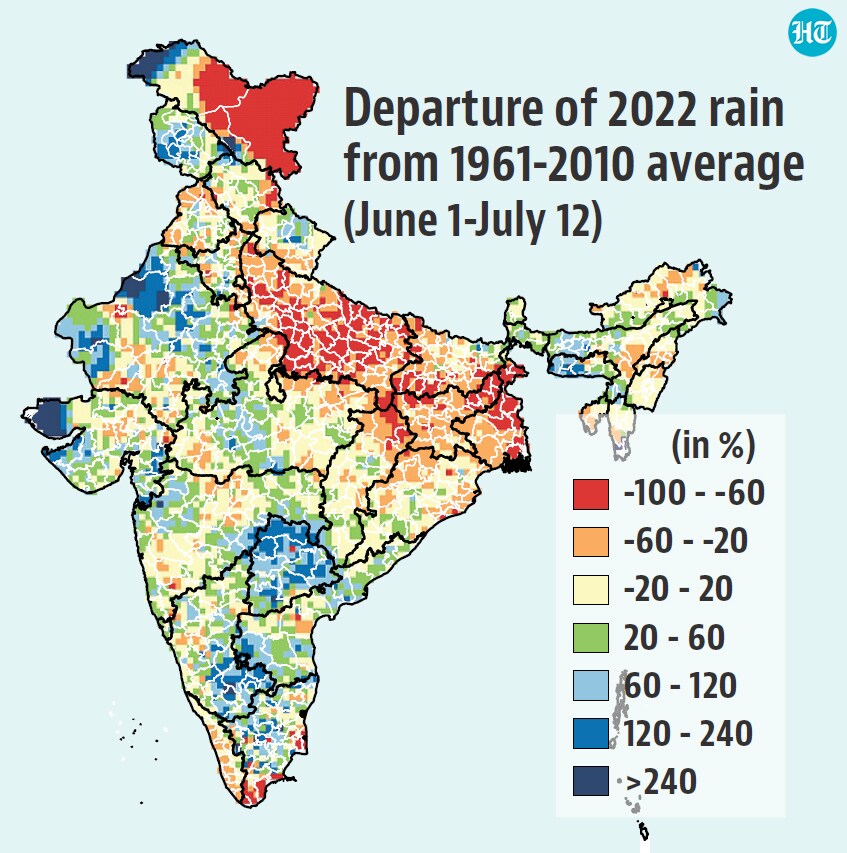
Yet, an analysis of data by regions, shows that the Gangetic plains are running the biggest deficit in the country, a trend that has persisted for this region throughout this monsoon for different reasons. If rainfall does not improve in this region in the next few days -- there are signs which suggest it may not -- farmers might have reason to worry.
Rainfall deficit biggest in the Gangetic plains...
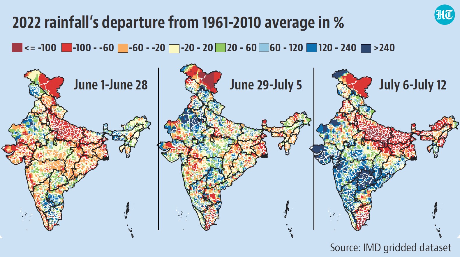
According to IMD’s gridded dataset, India has received 302.2 mm rainfall up to 8:30 AM on July 12. This is 13.7% more than the 1961-2010 average. As is the case with averages, this hides daily and regional variations. The biggest reason for concern is a large deficit in the Gangetic plains. Total rainfall from June 1 is 56.5% less than the 1961-2010 average in Uttar Pradesh, 48.6% less in Jharkhand, 26.5% less in West Bengal, and 27.8% less in Bihar. To be sure, such a deficit of 20% or more, which falls in the deficient category, is also seen in parts of other states. Indeed, almost a third of the country (1,461 of 4,685 grids) falls in this category. However, it is in these four states listed above that the deficit is the sharpest and most widespread.
... which might have delayed paddy sowing this year
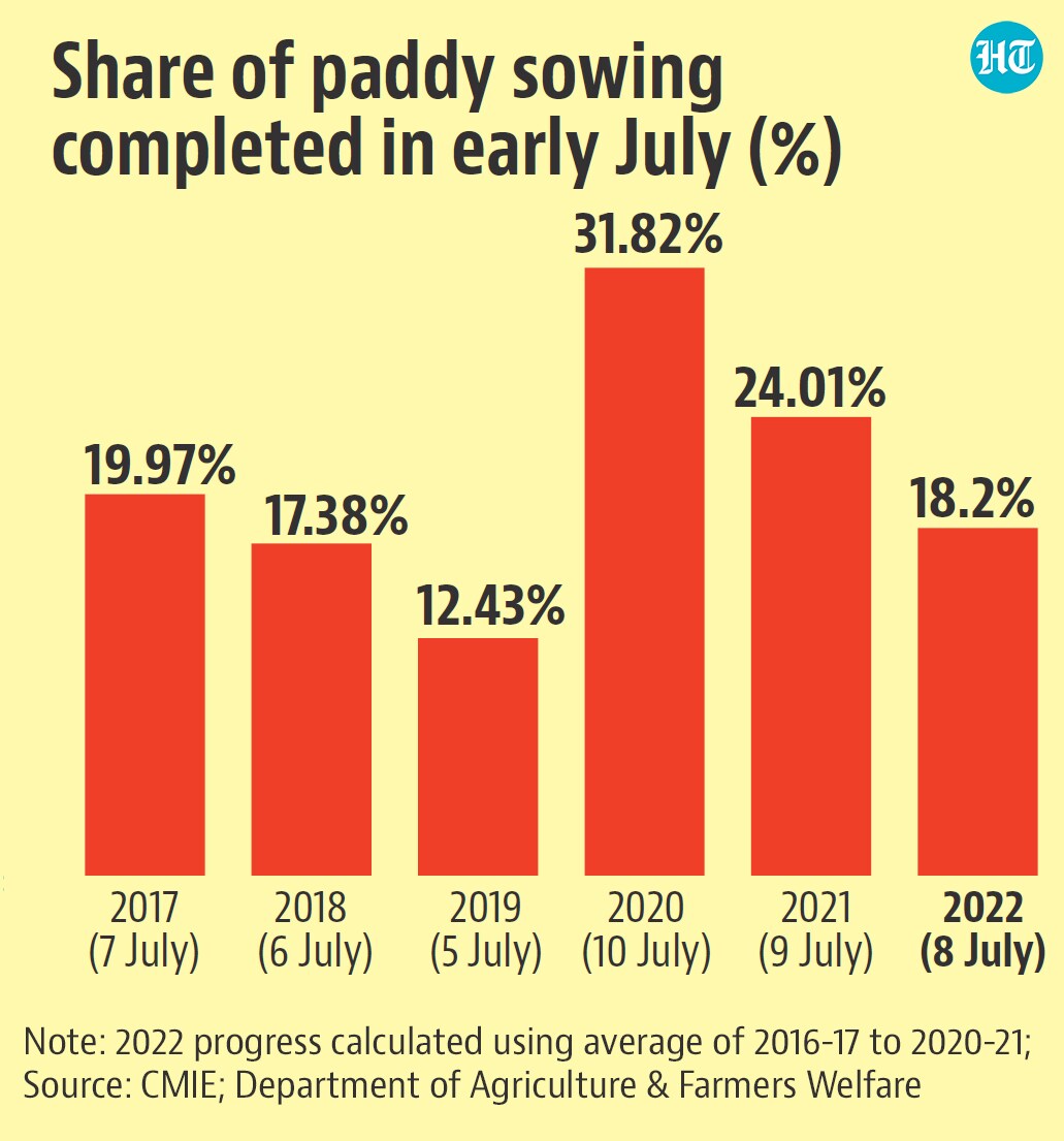
More than a third of paddy cultivation area is in Uttar Pradesh, Bihar, Jharkhand, and West Bengal, the states running the biggest deficit in monsoon rainfall. Initial data from the Centre for Monitoring Indian Economy’s (CMIE) database shows that as of July 8, paddy sowing was 18% of the average of normal kharif season rice sowing area between 2016-17 and 2020-21. This is lower than the corresponding proportion in the past few years. By July 10 in 2020 and July 9 in 2021, 32% and 24% of the normal paddy sowing for the season was complete. To be sure, it is the 2017-18 to 2021-22 period that will be used to calculate the normal sown area for this season (and this is not available yet). However, the lower coverage even in terms of earlier periods suggests that some of the paddy sowing has been delayed.
A bigger deficit in early July might be a bigger problem than overall deficit
As far as monsoon’s link to agricultural production is concerned, rainfall performance is critical windows matters more than the overall rainfall . This critical window varies for different regions.
The normal date of arrival of monsoon over the most western part of Uttar Pradesh is June 30. Immediately after, there is a 10 percentage point progress in paddy sowing each week in the first two weeks of July. This year, while the monsoon did cover Uttar Pradesh by June 30, large parts of Jharkhand and West Bengal and some parts of Uttar Pradesh and Bihar experienced lower than normal rainfall in the first week of July. The second week of July has been even worse than the first, with the entire region running dry (much like June). When read with the fact that sowing progress is slow, there is reason to believe that dry spells have interrupted the cultivation of kharif crops.
What explains the dry spell over Gangetic plains?
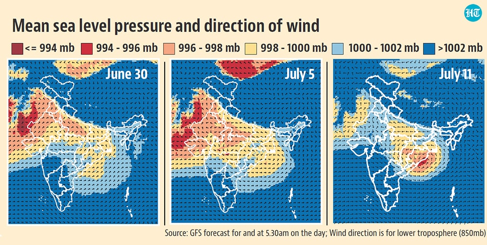
Experts say the reason is that the monsoon trough shifted southward in July and has remained there. The monsoon trough is an elongated low-pressure area extending from Bay of Bengal to Pakistan that forces moisture-laden air to rise up and cause rainfall during the monsoon season over this region. Although there are thresholds defined by IMD for this trough, it can be identified on pressure maps by winds running anticlockwise around an area of relatively lower pressure. As shown in the accompanying maps, this trough shifted southward after June 30.
“This month the trough has remained south leading to torrential rains over central India and absolutely dry conditions over the Indo-Gangetic Plains region particularly Jharkhand, Bihar, parts of Uttar Pradesh and West Bengal. The western end of the trough has sometimes shifted slightly northward leading to only patchy rains over Haryana, Punjab, etc, but no rain over Delhi. So even while we have 5% excess rainfall over the country, I don’t think it is benefitting farmers,” said Mahesh Palawat, vice president, climate change and meteorology, Skymet Weather.
However, according to M Rajeevan, meteorologist and former secretary at ministry of earth sciences, the southward movement of the trough is expected in July and may not necessarily be bad. “We have to remember that the northwestern states have irrigation but the central and western states like Gujarat and Maharashtra are mostly rain-fed so it’s important that it rains in these regions,” he said.