Cyclone Asna, which originated as a depression over Gujarat, formed over the Arabian Sea on Friday, marking only the fourth such occurrence in August since 1891.
The India Meteorological Department (IMD) said on Friday that the deep depression over the Kutch coast and adjoining areas of Pakistan and Northeast Arabian Sea intensified into a cyclonic storm and was centred about 190 kilometres west-northwest of Bhuj (Gujarat), 100 kilometres west-northwest of Naliya (Gujarat), and 170 kilometres southeast of Karachi (Pakistan) at 11.30am.
While the cyclone is unlikely to unleash the sort of destruction caused by a recent low-pressure system that turbocharged the monsoon rains in Gujarat over the last week, Asna is rare and scientifically intriguing, meteorologists said.
Also Read | Gujarat floods: IMD warns of ‘cyclone’; several towns, villages remain inundated
Unlike typical cyclones that form over warm ocean waters, Asna developed over land in Rajasthan, moved through North Gujarat, and then intensified upon reaching the Arabian Sea.
Ashok Kumar Das, scientist and head of the IMD Met Centre in Ahmedabad, highlighted the rarity of this event: “This is a rare occurrence. The last time something similar happened was in 1976, when a depression formed on land, transitioned into a cyclone, and then moved out to sea. Usually, it’s the other way around.”
Asna is further slated to intensify as it heads west, towards Oman. The Arabian Sea’s current temperature of 27-28°C is just above the 26.5°C threshold typically required for cyclone formation. When it enters the Gulf of Aden, it will encounter very warm waters at over 32°C. The temperature gradient between the colder west-central Arabian Sea and the warmer surrounding waters could influence the cyclone’s trajectory and strength.
{{/usCountry}}Asna is further slated to intensify as it heads west, towards Oman. The Arabian Sea’s current temperature of 27-28°C is just above the 26.5°C threshold typically required for cyclone formation. When it enters the Gulf of Aden, it will encounter very warm waters at over 32°C. The temperature gradient between the colder west-central Arabian Sea and the warmer surrounding waters could influence the cyclone’s trajectory and strength.
{{/usCountry}}Also Read | More rain likely in Gujarat, IMD predicts cyclonic storm Asna
According to IMD data, only on three occasions (1976, 1964 and 1944) have cyclones originated over mainland India in August and gathered strength as they entered the Arabian Sea. In 1976, the storm formed over Odisha, moved west-northwestwards across the plains, emerged into the Arabian Sea, made a loop, and weakened over the northwest Arabian Sea near the Oman coast.
In 1944, a cyclone similarly intensified and emerged into the Arabian Sea before weakening over the waters. In 1964, a short-lived cyclone developed near the South Gujarat coast and weakened near the coast.
In contrast, the Bay of Bengal has recorded 28 such systems in August over the past 132 years, according to the IMD.
Current environmental conditions indicate sea surface temperatures of 28-30 degrees Celsius over the Bay of Bengal and around 27-28 degrees Celsius over the Arabian Sea.
Speaking about why this activity is unusual, M Rajeevan, former secretary, ministry of earth sciences and climate scientist, said that one of the reasons could be because the Indian Ocean remaining warm. “In monsoon, depressions do not intensify to cyclone. Over Arabian Sea, wind shear should be high during this season which is also not suitable for intensification. That is why I am surprised,” said Rajeevan.
According to Rajeevan, normal temperatures over Arabian Sea during this season are expected to be 25 to 26 degree C.
Recent studies show that cyclones are becoming more frequent on the western coast due to climate crisis and the warming of the Arabian Sea, with states like Gujarat, Maharashtra, and Rajasthan facing increasingly intense storms. “According to a CEEW study, over 41% of districts in the western zone are now cyclone hot spots. Gujarat can significantly enhance safety during cyclones by channelling funds into constructing robust structures. Prioritising early response through well-prepared shelters will strengthen our resilience, reducing potential loss of life and property,” said Vishwas Chitale, Senior Programme Lead, CEEW
Meanwhile, a well-marked low-pressure area over the west-central and adjoining northwest Bay of Bengal off north Andhra Pradesh and South Odisha is expected to intensify into a depression within the next 36 hours. This system is likely to bring very heavy rainfall to Odisha, Coastal Andhra Pradesh, Chhattisgarh, Vidarbha, and Telangana over the next 2-3 days.
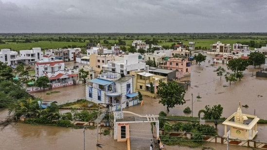
The formation of Cyclone Asna follows a period of severe weather that has already battered parts of Gujarat. Chief Minister Bhupendra Patel visited the rain-affected Devbhumi Dwarka district on Wednesday to oversee ongoing relief efforts. Khambhaliya, one of the worst-hit areas, recorded an extraordinary 944 mm of rainfall over five days, causing widespread disruption and displacement.
Rescue operations have been in full swing, with the Indian Coast Guard and Indian Army working tirelessly to save lives both at sea and on land.
On Thursday morning, an ALH helicopter of the Indian Coast Guard rescued four crew members from the fishing boat ‘Dostana,’ which was stranded 30 km southwest of Dwarka in precarious conditions.
The Coast Guard also conducted multiple helicopter operations, evacuating 24 people, including five women and two children, from the flood-stricken villages of Dumthar, Thepada, and Kutiyana. Many of those rescued were stranded on rooftops or clinging to pillars for safety. Between 28 and 29 August 2024, the Coast Guard successfully evacuated a total of 57 stranded individuals and 17 fishermen.
The Army mobilised eight columns, equipped with engineering resources and medical expertise, to provide critical assistance and disaster relief in Vadodara, Jamnagar, Dwarka, Rajkot, Morbi, and Bhuj. In one notable incident, the Indian Army rescued eight people, including six children, who were trapped for four days in a village in Jodiya, Jamnagar district.
Vadodara has been especially hard-hit by the monsoon, with the rapid rise of the Vishwamitri River leading to severe flooding. The Indian Army on Thursday rescued over 200 people from flood-affected areas in the city, relocating them to safer locations.
As of Thursday, 130 people had been rescued in Devbhumi Dwarka district, and 1,596 individuals had been relocated to safer areas. Over 12,000 food packets have been distributed to those displaced by the flooding.
In the last 24 hours ending at 4pm on Friday, Kutch recorded the highest rainfall at 112.50mm. Mandvi in Kutch emerged as the wettest location, recording 388mm of rainfall.
The state has received a total of 980.37mm of rainfall so far this year, which is 111.03% of the average annual rainfall. At least 35 people have died so far in rain-related incidents across the state since August 25.