E-Paper



January 2022 new benchmark for most rain, cleanest AQI in Delhi
Delhi also ended the month with a total rainfall of 88.2mm, the most in January in at least 121 years, according to IMD records. The previous record was 79.7mm in 1989

 Prefer HTon Google


January has been a record-breaking month for Delhi’s weather, with the month finishing with an average maximum temperature of just 18 degrees Celsius (°C), 2.4 notches below the average monthly normal for the month, making it the joint second-coldest January in 72 years, according to data shared by the India Meteorological Department (IMD).
While Delhi recorded an average maximum of 18°C in January 2015 as well, it was only lower in 2003, when it dipped to 17.6°C.
Delhi also ended the month with a total rainfall of 88.2mm, the most in January in at least 121 years, according to IMD records. The previous record was 79.7mm in 1989.
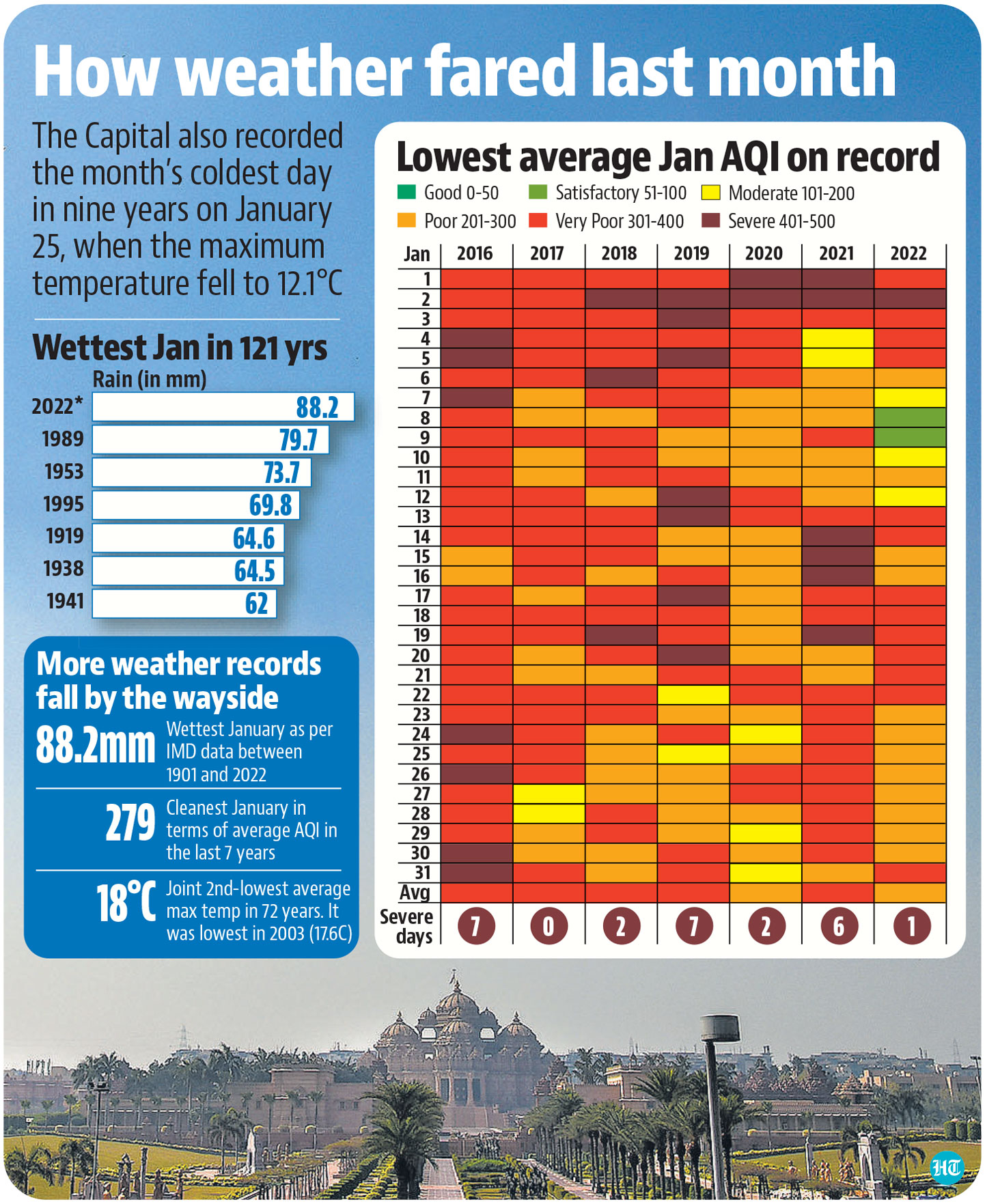
Frequent spells of rain and strong winds have also meant that Delhi’s average air quality index (AQI) for the month was only 279 – the lowest since the metric was launched in April 2015.
The previous lowest average AQI for January was in 2020, when it was 286, data from the Central Pollution Control Board (CPCB) showed. Delhi recorded a “severe” air day on January 2 alone, with either spells of rain, or strong winds ensuring Delhi’s AQI did not cross the 400 mark. In comparison, Delhi saw seven “severe” air days in December last year and 11 in November.
The city saw six ‘severe’ air days in January last year, showed CPCB data.
An AQI is classified “poor” by the CPCB when it is between 201 and 300, ‘very poor’ when it is between 301 and 400 and “severe” when it crosses 400.
The maximum temperature in Delhi stayed below the 17°C mark on 13 days in January, showed IMD data. The month also recorded seven “cold” days, including two “severe cold” ones.
The Capital also recorded the month’s coldest day in nine years on January 25, when the maximum fell to 12.1°C. The last time the maximum was lower was on January 3, 2013, when it fell to 9.8°C.
The IMD classifies it as a cold day when the maximum temperature is 4.5 degrees or more below the normal mark, with the minimum also being below the 10-degree mark. It is classified as a ‘severe cold’ day when the maximum is 6.5 degrees or more below the normal mark.
The last time Delhi had recorded more days when the maximum was below the 17-degree mark was in 2003, when the city saw 19 such days.
“We have recorded seven western disturbances in the month, as against five normally. But two of these were extremely active and brought moderate spells of rainfall. Generally, one active western disturbance is seen in January every few years and even then, light to moderate showers are seen. This time, we saw two moderate spells of rainfall, which has led to the rainfall record breaking and has also kept Delhi’s air fairly clean. After the departure of the western disturbance, we saw windy conditions, which did not allow the air quality to deteriorate,” said RK Jenamani, scientist at IMD.
He said the two most active western disturbances, from January 6 to 9 and January 21 to 23, were also followed by cold day conditions, with enough moisture being added to the air to create upper-level fog.
“Instead of fog forming on the surface, it formed at 500 to 1,000 metres over the surface, which restricted sunlight which kept the maximum temperature so low,” said Jenamani.
Delhi recorded a maximum temperature of 22.2°C on Monday, normal for this time of the season. The minimum was 6.4°C – two below the normal mark.
IMD has forecast another active western disturbance to bring rain to Delhi on February 3 and 4, which could bring down the maximum temperature once again.
Meanwhile, Delhi’s AQI was 338 (very poor), with a slight drop in wind speed giving Delhi worse pollution levels on Monday. The AQI was 278 (poor) on Sunday, according to the Central Pollution Control Board’s (CPCB) 4pm bulletin.
Dipankar Saha, former head of CPCB’s air laboratory says meteorological factors play a key role in the winter months, with a dense layer of upper-level fog stretching through the entire Indo-Gangetic Plains in January, which began due to the strong western disturbances prevailing in the region. “This kicked off with a strong western disturbance in the first and second week, which brought plenty of rain to Delhi and the northern plains. There was also heavy snowfall in the mountains and since then, temperatures have plummeted and wind speed has remained high. A second such spell in the third week only added more rain and once again led to temperatures dropping sharply,” said Saha, stating December in comparison was warmer, owing to very little rain activity.