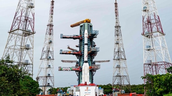
The Indian Space Research Organisation's (Isro) launch of NVS-03 at 11.51pm on Friday is an attempt to bolster NavIC – India's answer to GPS – which has been unable to give a position without foreign navigation systems since March because too few of its satellites are working.
GPS is the US government-owned system that most services and institutions rely on to find a location and keep time. India built NavIC so that it would not have to depend on a system controlled by another government, especially in times of a conflict. But the project has been dogged by failing atomic clocks, a satellite lost at launch and another that never reached its working orbit.
The system currently has three satellites providing navigation signals, one fewer than the minimum it needs to give a position, though it can still give the time, the government told Parliament in July.
Why India wanted its own system
The US's Global Positioning System (GPS), Russia's Global Navigation Satellite System (Glonass), Europe's Galileo and China's BeiDou Navigation Satellite System cover the whole world. Japan runs a regional system, the Quasi-Zenith Satellite System (QZSS), for itself and its neighbourhood. NavIC, short for Navigation with Indian Constellation, is India's regional equivalent.
GPS and Glonass are run by the defence agencies of the US and Russia, so their civilian service could be degraded or denied at any time, an Isro official had told HT in 2023. "NavIC is an independent regional system over the Indian region and does not depend on other systems for providing a position service within the service region. It is fully under the control of the Government of India," the official had said.
{{/usCountry}}GPS and Glonass are run by the defence agencies of the US and Russia, so their civilian service could be degraded or denied at any time, an Isro official had told HT in 2023. "NavIC is an independent regional system over the Indian region and does not depend on other systems for providing a position service within the service region. It is fully under the control of the Government of India," the official had said.
{{/usCountry}}The government approved the programme in May 2006 "to establish an independent and indigenous satellite based navigation system over the Indian landmass and surrounding region", according to a report by the Comptroller and Auditor General (CAG), the government auditor.
Besides navigation signals, the atomic clocks on these satellites give the time as well. Banks, stock exchanges and the armed forces rely on precise time, and small differences between time sources can affect their operations. For this, India has been building a separate source on the ground as well. In June 2025, the government said it would stop using GPS to keep Indian Standard Time and switch to five atomic clocks in Guwahati, Bengaluru, Ahmedabad, Faridabad and Bhubaneswar. It said the clocks had been tested, that the system would be running soon, and that banks and businesses would have to use it once it was.
How satellite navigation works
Every navigation satellite constantly broadcasts two pieces of information: where it is, and the exact time.
A receiver, such as the chip in a phone or a ship's navigation unit, works out how long each signal took to reach it by comparing the moment the signal left the satellite, which is stamped on the signal, and the moment it reached the receiver, by the receiver's own clock. Radio signals travel at the speed of light, so the delay tells the receiver how far away the satellite is.
Knowing its distance from one satellite places the receiver somewhere on an imaginary ball around that satellite. Distances from three satellites would narrow that down to a single point near Earth's surface, if the receiver's own clock were exact.
That isn't usually the case. The satellites keep time with atomic clocks, but a phone, or any other receiver a user has, runs on an ordinary clock that is far less precise. This makes a difference because radio signals cover about 300 metres in a millionth of a second. A receiver whose clock is a millionth of a second fast or slow will get every distance wrong by about 300 metres, and location would be hundreds of metres away from where it really is.
A fourth satellite plugs this gap by giving one more measurement, enough to work out that error and correct all its distances.
That is why a receiver needs signals from at least four satellites to find its position. The method also depends on the satellites' clocks being exact. A satellite whose atomic clocks have all failed can no longer help a receiver find its position.
IRNSS-1B, IRNSS-1I and NVS-01 are now providing NavIC's navigation signals, Jitendra Singh, the minister in charge of the Department of Space, told the Lok Sabha in a written reply on July 29. "To provide basic positioning service, minimum four operational satellites are required in orbit. Hence, the NavIC constellation cannot provide standalone positioning service, however timing service is functional," he said. NavIC can still give users the exact time, but with only three satellites working it cannot tell them where they are.
Also read: Starshield, the SpaceX satellite service Ukraine’s drones rely on, and who controls it
Seven satellites, higher up
NavIC covers India and a region extending 1,500km beyond its borders, and its signals are free for civilian use, the government told the Lok Sabha in 2022. Its satellites orbit about 36,000km above Earth, against about 20,000km for GPS satellites, the government told the Rajya Sabha the same year.
At about 36,000km, a satellite circles Earth once a day, in step with the planet's rotation. NavIC's design places three of its seven satellites in geostationary orbit, directly above the equator, where they appear fixed in the sky. The other four are in inclined geosynchronous orbits, tilted to the equator, so seen from the ground, they appear to stay over the same stretch of longitude, drifting north and south, according to Nasa. That keeps NavIC's satellites over India and its neighbourhood.
GPS satellites are lower, circle Earth more often and keep moving across the sky. A system built that way needs many more satellites to cover the whole planet.
NavIC serves only one region and can work with fewer, at lower cost.
NavIC was designed as seven satellites working together, backed by ground stations, including a control centre and a precise timing facility, that run round the clock. It needs at least four of them working to give a position, and Isro officials said in 2016 that services could begin with four. It offers a standard positioning service for civilians and a restricted service for strategic users, and Isro designed it to give a user's position to within 20m and the time to within 50 nanoseconds, or billionths of a second.
On April 28, 2016, the day the seventh satellite, IRNSS-1G, was launched, Prime Minister Narendra Modi said the system would be known as NavIC. "The world will know it as Navic.... The new technology will benefit our people, our fishermen. This is a great gift to people from scientists," he had said.
NavIC also broadcasts one-way messages, used to warn of cyclones, tsunamis and high waves, and to keep fishermen from straying into foreign waters.
When four navigation satellites were working, more than 10,400 locomotives, 40,000 fishing vessels and at least 60 mobile handset models used NavIC for tracking, emergency alerts and positioning.
Where it went wrong
Satellites and their parts wear out or fail, and Isro has had to keep launching replacements to hold seven in service. It has launched 11 navigation satellites since 2013, and three are providing navigation signals now, according to Singh's replies in the Lok Sabha. NVS-03 will be the 12th.
All three atomic clocks on IRNSS-1A, the first satellite, failed, the government told the Rajya Sabha in 2018. The clocks came from Spectra Time, a Swiss company now part of the French defence group Safran. Its first replacement, IRNSS-1H, was lost in 2017 when the casing around it failed to separate after launch. A second, IRNSS-1I, reached orbit in 2018. Its clocks carried a fix for the fault traced on IRNSS-1A, an overheated capacitor in the power supply, Singh told the Rajya Sabha.
The system became operational that year, nearly seven years late. A CAG report in March 2018 attributed the holdup to "delays in execution of contracts, deficient monitoring of programme and inadequate follow up".
NVS-02, launched in January 2025, never reached its working orbit. An electrical signal failed to reach a pyro valve, a single-use valve opened by a small explosive charge, and the satellite's engine could not fire, an Isro inquiry found.
The armed forces use NavIC alongside other systems, and Singh says there is "no vulnerability for the users".
Also read: Why ‘Naughty Boy’ satellite launch, Isro's 1st success this year, is a giant leap for India
What NVS-03 has to do
The GSLV-F18 rocket, lifting off from the second launch pad at the Satish Dhawan Space Centre in Sriharikota, is due to leave NVS-03 in a transfer orbit, a stretched oval that swings between 170km and about 37,000km above Earth, according to Isro's mission brochure. The satellite then has to fire its own engine to climb into the circular orbit where it can begin work.
NVS-02 had failed at that second step. Singh told the Lok Sabha in August that NVS-03 was ready "after incorporation of all corrective measures arising from the NVS-02 anomaly".
NVS-03 has an Indian-made atomic clock alongside procured ones, according to an Isro statement on October 28, and, like NVS-01, carries a third signal, called L1, in addition to the two that NavIC's first-generation satellites broadcast L1 is a civilian signal designed to work alongside other global navigation systems, and it lets cheaper consumer gadgets such as smartwatches pick up NavIC.
If NVS-03 reaches its slot and enters service, NavIC would again have the four working satellites it needs to give a position on its own. Even then, the system would depend on IRNSS-1B, one of the three satellites still working, which was launched in April 2014 with a 10-year mission life and is now in its 13th year.
Isro's longer-term aim is a system that works worldwide. "Currently, NavIC's reach is only 1,500km beyond Indian territory. But for our ships and airplanes travelling beyond that we will need satellites in medium earth orbit (MEO). So, to make this a global system, we can keep adding MEO satellites. This is the goal," S Somanath, then Isro chairman, said in 2023. Medium earth orbit is the band where GPS satellites fly, about 20,000km up.
In July 2025, Singh told the Lok Sabha that NVS-03 would be launched by the end of that year, with NVS-04 and NVS-05 following at six-month intervals. In July this year, he said NVS-04 and NVS-05 were "in advanced stage of realisation". He said in August that one more satellite was planned after them to complete NavIC's core constellation of seven.