Cyclone Arnab LIVE: Storm to turn ‘severe’ today, ‘very severe’ tomorrow; Army, IAF ready with ships jets
Cyclone Arnab LIVE: The IMD has issued red alert for October 28 and 29 for parts of Andhra Pradesh and Odisha in view of Cyclone Arnab, which is expected to make landfall on Thursday, crossing Andhra Pradesh and Yanam coasts between Bapatla and Visakhapatnam.
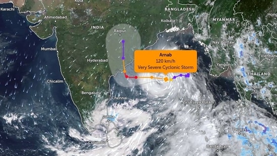
Cyclone Arnab LIVE: The deep depression over eastcentral and adjoining southeast Bay of Bengal has intensified into Cyclone ‘Arnab’ and is expected to ultimately turn into a “very severe cyclonic storm” later this week, the India Meteorological Department (IMD) said on Monday....Read More
At 11:30 am on Monday the cyclonic storm Arnab lay centered 550 km southeast of Gopalpur (Odisha), 580 km east-southeast of Vishakhapatnam (Andhra Pradesh), 650 km northwest of Sri Vijaya Puram (Andaman Islands), 660 km east-southeast of Kakinada (Andhra Pradesh), 760 km east-southeast of Machilipatnam (Andhra Pradesh) and 830 km east-southeast of Bapatla (Andhra Pradesh).
Cyclone Arnab updates | Key points
-Cyclone Arnab forms: The deep depression over eastcentral and adjoining southeast Bay of Bengal intensified into cyclonic storm “Arnab” [Pronunciation: Ornab], the India Meteorological Department (IMD) said in a post on X, at around 9 am, on Monday.
-Cyclone Arnab current status: The weather department said, at 11:30 am, cyclonic storm Arnab lay centered 550 km southeast of Gopalpur (Odisha), 580 km east-southeast of Vishakhapatnam (Andhra Pradesh), 650 km northwest of Sri Vijaya Puram (Andaman Islands), 660 km east-southeast of Kakinada (Andhra Pradesh), 760 km east-southeast of Machilipatnam (Andhra Pradesh) and 830 km east-southeast of Bapatla (Andhra Pradesh).
-Cyclone Arnab to be ‘very severe cyclonic storm’: Cylone Arnab is very likely to move west-northwestwards and intensify further into a ‘severe cyclonic storm’ over westcentral Bay of Bengal by midnight of October 26 and into a ‘very severe cyclonic storm’ over the same region on October 27.
-Cyclone Arnab landfall: The IMD said Cyclone Arnab is very likely to move northwestwards and cross Andhra Pradesh and Yanam coasts between Bapatla and Visakhapatnam as a ‘very severe cyclonic storm’, with the maximum sustained wind speed of 115-125 kmph gusting to 140 kmph, by forenoon of Wednesday, October 28.
- {{^htLoading}} {{/htLoading}}
- 26 Oct 2026, 06:00:46 PM IST
Cyclone Arnab LIVE: Andhra Pradesh landfall likely on October 28, says IMD
⚠️ चक्रवात ‘अर्णब’ के प्रभाव से उत्तर प्रदेश में वर्षा, गरज-चमक और तेज हवाओं की संभावना मौसम संबंधी पूर्वानुमान के अनुसार, 28 से 31 अक्टूबर के दौरान उत्तर प्रदेश के विभिन्न जनपदों में चक्रवात ‘अर्णब’ के संभावित प्रभाव से बेमौसम बारिश, गरज-चमक और 40–50 किमी/घंटा की रफ्तार से झोंकेदार हवाएं चलने की संभावना है। इससे दिन के तापमान में 5–8°C तक गिरावट आ सकती है। 📍 जनपदवार संभावित प्रभाव 🔸 28 अक्टूबर | येलो अलर्ट सोनभद्र, मिर्जापुर, चंदौली, वाराणसी, भदोही, गाजीपुर एवं बलिया में 30–40 किमी/घंटा की रफ्तार से तेज हवाएं चलने की संभावना है। 🔸 29 अक्टूबर | ऑरेंज अलर्ट — सर्वाधिक प्रभाव की संभावना • भारी वर्षा: चित्रकूट, कौशांबी, प्रयागराज, फतेहपुर, प्रतापगढ़, वाराणसी मंडल, रायबरेली, अमेठी एवं सुल्तानपुर में भारी बारिश की संभावना है। • तेज झोंकेदार हवाएं: बांदा से कानपुर, उन्नाव, लखनऊ, बाराबंकी, अयोध्या, रायबरेली, अमेठी एवं सुल्तानपुर होते हुए गोंडा और बलरामपुर तक के क्षेत्रों में 40–50 किमी/घंटा की रफ्तार से हवाएं चलने की संभावना है। 🔸 30 अक्टूबर | ऑरेंज अलर्ट गाजीपुर, आजमगढ़, मऊ, बलिया, देवरिया, गोरखपुर, बस्ती, गोंडा, बहराइच, श्रावस्ती, अयोध्या, सुल्तानपुर, सीतापुर, लखीमपुर खीरी, बरेली, पीलीभीत एवं शाहजहांपुर में भारी वर्षा और 40–50 किमी/घंटा की रफ्तार से तेज हवाएं चलने की संभावना है। 🛡️ जनसुरक्षा परामर्श ▪️ 24 से 27 अक्टूबर के बीच मौसम शुष्क रहने की संभावना को देखते हुए आवश्यक तैयारियां समय रहते पूरी कर लें। ▪️ मौसम संबंधी चेतावनियों एवं प्रशासन द्वारा जारी दिशा-निर्देशों का पालन करें। ▪️ आंधी-तूफान के दौरान सुरक्षित पक्के भवन में शरण लें तथा पेड़ों, बिजली के खंभों और कमजोर संरचनाओं से दूर रहें। ▪️ बिजली कड़कने के दौरान खुले मैदान, खेत, जलाशयों एवं ऊंचे स्थानों पर जाने से बचें। ▪️ तेज हवाओं एवं बारिश के दौरान अनावश्यक यात्रा से बचें। ▪️ किसान भाई फसलों, कृषि उपज एवं पशुधन की सुरक्षा के लिए आवश्यक सावधानियां बरतें। ▪️ मौसम की नवीनतम जानकारी के लिए आधिकारिक मौसम बुलेटिन एवं सचेत ऐप पर जारी अलर्ट देखते रहें। सतर्क रहें, सुरक्षित रहें। नोट: यह संभावित मौसम प्रभाव का पूर्वानुमान है। जनपदवार चेतावनियों एवं उनकी वैधता की पुष्टि भारत मौसम विज्ञान विभाग (IMD) के नवीनतम बुलेटिन से अवश्य करें। #ArnabCyclone #WeatherAlert #UPWeather #RainAlert #RahatUP #जनहित_में_जारी @CMOfficeUP @ChiefSecyUP @Revenue_UPGov @NDRFHQ @Dgpacup @InfoDeptUP @rahat_up @UP_SDMA @OfficeOfDMAgra @Dm_Aligarh @AmbedkarnagarDM @DmAmethi @dmamroha @DMAuraiya @dmayodhya @dmazamgarh @BagpatDm @DMBahraich @dmballia @DMBalrampur @DM_Banda1 @DM_Barabanki @dmbareilly @dmbas_ @dmbijnor @dmbudaun @dmbulandshahr @dmchandauli @ChitrakootDm @dmdeoria @DM_Etah @DistrictEtawah @DMFarrukhabadUP @dmfatehpur @dm_firozabad @dmgbnagar @dm_ghaziabad @AdminGhazipur
— Rahat UP (@rahat_up) October 26, 2026Cyclone Arnab LIVE: Cyclone Arnab is moving west-northwestwards over the Bay of Bengal and is expected to intensify into a very severe cyclonic storm by October 27, the India Meteorological Department (IMD) said on Monday. The storm is forecast to cross the Andhra Pradesh and Yanam coasts between Bapatla and Visakhapatnam, close to Yanam, by the forenoon of October 28, with maximum sustained wind speeds of 115–125 kmph and gusts of up to 140 kmph.
At 2.30 pm on October 26, the storm was located about 520 km southeast of Gopalpur in Odisha and 540 km east-southeast of Visakhapatnam in Andhra Pradesh. It had moved west-northwestwards at 13 kmph over the previous six hours.
- 26 Oct 2026, 05:51:22 PM IST
Cyclone Arnab LIVE: Orange alert for UP districts on October 29 and 30
⚠️ चक्रवात ‘अर्णब’ के प्रभाव से उत्तर प्रदेश में वर्षा, गरज-चमक और तेज हवाओं की संभावना मौसम संबंधी पूर्वानुमान के अनुसार, 28 से 31 अक्टूबर के दौरान उत्तर प्रदेश के विभिन्न जनपदों में चक्रवात ‘अर्णब’ के संभावित प्रभाव से बेमौसम बारिश, गरज-चमक और 40–50 किमी/घंटा की रफ्तार से झोंकेदार हवाएं चलने की संभावना है। इससे दिन के तापमान में 5–8°C तक गिरावट आ सकती है। 📍 जनपदवार संभावित प्रभाव 🔸 28 अक्टूबर | येलो अलर्ट सोनभद्र, मिर्जापुर, चंदौली, वाराणसी, भदोही, गाजीपुर एवं बलिया में 30–40 किमी/घंटा की रफ्तार से तेज हवाएं चलने की संभावना है। 🔸 29 अक्टूबर | ऑरेंज अलर्ट — सर्वाधिक प्रभाव की संभावना • भारी वर्षा: चित्रकूट, कौशांबी, प्रयागराज, फतेहपुर, प्रतापगढ़, वाराणसी मंडल, रायबरेली, अमेठी एवं सुल्तानपुर में भारी बारिश की संभावना है। • तेज झोंकेदार हवाएं: बांदा से कानपुर, उन्नाव, लखनऊ, बाराबंकी, अयोध्या, रायबरेली, अमेठी एवं सुल्तानपुर होते हुए गोंडा और बलरामपुर तक के क्षेत्रों में 40–50 किमी/घंटा की रफ्तार से हवाएं चलने की संभावना है। 🔸 30 अक्टूबर | ऑरेंज अलर्ट गाजीपुर, आजमगढ़, मऊ, बलिया, देवरिया, गोरखपुर, बस्ती, गोंडा, बहराइच, श्रावस्ती, अयोध्या, सुल्तानपुर, सीतापुर, लखीमपुर खीरी, बरेली, पीलीभीत एवं शाहजहांपुर में भारी वर्षा और 40–50 किमी/घंटा की रफ्तार से तेज हवाएं चलने की संभावना है। 🛡️ जनसुरक्षा परामर्श ▪️ 24 से 27 अक्टूबर के बीच मौसम शुष्क रहने की संभावना को देखते हुए आवश्यक तैयारियां समय रहते पूरी कर लें। ▪️ मौसम संबंधी चेतावनियों एवं प्रशासन द्वारा जारी दिशा-निर्देशों का पालन करें। ▪️ आंधी-तूफान के दौरान सुरक्षित पक्के भवन में शरण लें तथा पेड़ों, बिजली के खंभों और कमजोर संरचनाओं से दूर रहें। ▪️ बिजली कड़कने के दौरान खुले मैदान, खेत, जलाशयों एवं ऊंचे स्थानों पर जाने से बचें। ▪️ तेज हवाओं एवं बारिश के दौरान अनावश्यक यात्रा से बचें। ▪️ किसान भाई फसलों, कृषि उपज एवं पशुधन की सुरक्षा के लिए आवश्यक सावधानियां बरतें। ▪️ मौसम की नवीनतम जानकारी के लिए आधिकारिक मौसम बुलेटिन एवं सचेत ऐप पर जारी अलर्ट देखते रहें। सतर्क रहें, सुरक्षित रहें। नोट: यह संभावित मौसम प्रभाव का पूर्वानुमान है। जनपदवार चेतावनियों एवं उनकी वैधता की पुष्टि भारत मौसम विज्ञान विभाग (IMD) के नवीनतम बुलेटिन से अवश्य करें। #ArnabCyclone #WeatherAlert #UPWeather #RainAlert #RahatUP #जनहित_में_जारी @CMOfficeUP @ChiefSecyUP @Revenue_UPGov @NDRFHQ @Dgpacup @InfoDeptUP @rahat_up @UP_SDMA @OfficeOfDMAgra @Dm_Aligarh @AmbedkarnagarDM @DmAmethi @dmamroha @DMAuraiya @dmayodhya @dmazamgarh @BagpatDm @DMBahraich @dmballia @DMBalrampur @DM_Banda1 @DM_Barabanki @dmbareilly @dmbas_ @dmbijnor @dmbudaun @dmbulandshahr @dmchandauli @ChitrakootDm @dmdeoria @DM_Etah @DistrictEtawah @DMFarrukhabadUP @dmfatehpur @dm_firozabad @dmgbnagar @dm_ghaziabad @AdminGhazipur
— Rahat UP (@rahat_up) October 26, 2026Cyclone Arnab LIVE: Uttar Pradesh may experience unseasonal rain, thunderstorms and gusty winds of 40–50 kmph from October 28 to 31 under the possible influence of Cyclone Arnab, according to an advisory issued by the state Relief Commissioner. An orange alert has been indicated for October 29 and 30 in several districts, with heavy rainfall expected in parts of the state. Daytime temperatures could drop by 5–8°C. Residents have been advised to follow official weather alerts, avoid unnecessary travel during storms and take precautions to protect crops and livestock.
- {{^htLoading}}
- 26 Oct 2026, 05:41:06 PM IST
Cyclone Arnab LIVE: Uttar Pradesh may see rain, strong winds from October 28
Cyclone Arnab LIVE: The India Meteorological Department’s regional centre in Lucknow has warned of unseasonal rainfall accompanied by strong winds in Uttar Pradesh from October 28 due to the impact of a cyclonic storm developing over the Bay of Bengal. The weather system could bring adverse weather conditions to parts of the state, prompting residents to stay updated on official forecasts and advisories.
- 26 Oct 2026, 05:33:22 PM IST
Cyclone Arnab LIVE: IMD issues heavy rainfall warning for Odisha, Andhra Pradesh, Bihar
मौसम संबंधी चेतावनी ! मुख्य बिंदु आने वाले चक्रवाती तूफान "अर्नब" के प्रभाव के कारण, 27 और 28 तारीख को तटीय आंध्र प्रदेश और यनम में; 28 तारीख को ओडिशा में; 28 और 29 तारीख को छत्तीसगढ़ में; और 29 तारीख को पूर्वी उत्तर प्रदेश में कहीं-कहीं बहुत भारी बारिश होने की संभावना है। इसके अलावा, 27 और 29 तारीख को ओडिशा में; 28 तारीख को विदर्भ और तेलंगाना में; 30 तारीख को पूर्वी मध्य प्रदेश और पूर्वी उत्तर प्रदेश में; 29 तारीख को झारखंड में; तथा 29 और 30 अक्टूबर, 2026 को बिहार में कहीं-कहीं भारी से बहुत भारी बारिश होने की संभावना है। Highlights Under the influence of impending Cyclonic Storm“Arnab”, isolated extremely heavy rainfall likely over Coastal Andhra Pradesh & Yanam on 27th & 28th, over Odisha on 28th and over Chhattisgarh on 28th & 29th, East Uttar Pradesh on 29th; isolated heavy to very heavy rainfall also likely over Odisha on 27th & 29th, over Vidarbha & Telangana on 28th, over East Madhya Pradesh, over East Uttar Pradesh on 30th, over Jharkhand on 29th and over Bihar on 29th and 30th October, 2026. South Peninsular India: ❖ Isolated to Scattered rainfall likely over Rayalaseema and Tamil Nadu, Puducherry & Karaikal during 26th October-1st November; Kerala & Mahe during 27th October-1st November; Lakshadweep on 27th October and on 1st November; Coastal Karnataka and South Interior Karnataka during 28th October-1st November; North Interior Karnataka during 29th October-1st November; Coastal Andhra Pradesh & Yanam on 26th October and during 30th October-1st November; Telangana on 27th October and during 29th October-1st November. ❖ Fairly Widespread to Widespread rainfall likely over Kerala & Mahe and Lakshadweep on 26th October; Coastal Andhra Pradesh & Yanam during 27th-29th October; Telangana on 28th October. ❖ Isolated thunderstorm, lightning & gusty winds (speed reaching 80-90 kmph) likely over Coastal Andhra Pradesh & Yanam during 27th-28th October, with gusty winds (speed reaching 40-50 kmph gusting to 60 kmph) likely over Coastal Andhra Pradesh & Yanam on 26th October and on 29th October; Rayalaseema during 27th-28th October, with gusty winds (speed reaching 30-40 kmph gusting to 50 kmph) likely over Kerala & Mahe and Lakshadweep on 26th October; North Interior Karnataka on 29th October; South Interior Karnataka on 28th October; Rayalaseema on 26th October and on 29th October; Telangana on 27th October and during 29th-30th October. ❖ Isolated thunderstorm & lightning likely over Tamil Nadu, Puducherry & Karaikal during 26th-27th October. ❖ Isolated heavy rainfall likely over Kerala & Mahe on 26th October; Coastal Andhra Pradesh & Yanam on 29th October; Telangana on 27th October and on 29th October with isolated very heavy rainfall also likely over Tamil Nadu, Puducherry & Karaikal on 26th October. ❖ Isolated extremely heavy rainfall likely over Coastal Andhra Pradesh & Yanam during 27th-28th October; Telangana on 28th October. ❖ Thundersquall (wind speed reaching 50-60 kmph gusting to 70 kmph) likely over Telangana on 28th October. ❖ Strong Surface Winds likely over North Interior Karnataka during 28th-29th October; South Interior Karnataka during 27th-28th October; Coastal Andhra Pradesh & Yanam and Rayalaseema during 26th-29th October. East India: ❖ Fairly Widespread to Widespread rainfall likely over Andaman & Nicobar Islands during 26th October-1st November; Sub-Himalayan West Bengal & Sikkim during 29th-30th October; Gangetic West Bengal during 28th-29th October; Jharkhand during 28th-30th October; Bihar during 29th-31st October; Odisha during 27th30th October. ❖ Isolated to Scattered rainfall likely over Sub-Himalayan West Bengal & Sikkim on 28th October and during 31st October-1st November; Gangetic West Bengal on 27th October and during 30th October-1st November; Jharkhand on 27th October and during 31st October-1st November; Bihar on 28th October and on 1st November; Odisha on 26th October and during 31st October-1st November. ❖ Isolated thunderstorm, lightning & gusty winds (speed reaching 40-50 kmph gusting to 60 kmph) likely over Andaman & Nicobar Islands during 26th-27th October; Gangetic West Bengal during 28th-29th October; Jharkhand on 30th October; Bihar during 28th-31st October; Odisha on 27th October, with gusty winds (speed reaching 30-40 kmph gusting to 50 kmph) likely over Andaman & Nicobar Islands during 28th-29th October; Sub-Himalayan West Bengal & Sikkim during 29th-31st October; Gangetic West Bengal on 27th October and on 30th October; Jharkhand on 27th October; Bihar on 1st November. ❖ Isolated heavy rainfall likely over Andaman & Nicobar Islands on 26th October and on 29th October; SubHimalayan West Bengal & Sikkim during 29th-30th October; Gangetic West Bengal during 28th-29th October; Jharkhand on 28th October and on 30th October; Bihar on 31st October with isolated very heavy rainfall also likely over Jharkhand and Odisha on 29th October; Bihar during 29th-30th October. ❖ Isolated extremely heavy rainfall likely over Odisha during 27th-28th October. ❖ Thundersquall (wind speed reaching 60-70 kmph gusting to 80 kmph) likely over Odisha on 28th October. ❖ Thundersquall (wind speed reaching 50-60 kmph gusting to 70 kmph) likely over Jharkhand during 28th29th October; Odisha on 29th October. Northwest India: ❖ Isolated to Scattered rainfall likely over Himachal Pradesh and Jammu-Kashmir-Ladakh-Gilgit-BaltistanMuzaffarabad during 29th-30th October; Uttarakhand during 28th October-1st November. ❖ Isolated to Scattered rainfall likely over Haryana Chandigarh & Delhi and Punjab during 28th-31st October; East Rajasthan and West Uttar Pradesh during 29th-31st October; East Uttar Pradesh on 28th October and during 31st October-1st November; West Rajasthan during 29th-30th October. ❖ Fairly Widespread to Widespread rainfall likely over East Uttar Pradesh during 29th-30th October. ❖ Isolated thunderstorm, lightning & gusty winds (speed reaching 40-50 kmph gusting to 60 kmph) likely over Jammu-Kashmir-Ladakh-Gilgit-Baltistan-Muzaffarabad on 30th October, with gusty winds (speed reaching 30-40 kmph gusting to 50 kmph) likely over Uttarakhand during 29th-30th October. ❖ Isolated thunderstorm, lightning & gusty winds (speed reaching 40-50 kmph gusting to 60 kmph) likely over East Uttar Pradesh on 31st October; East Rajasthan on 30th October, with gusty winds (speed reaching 30-40 kmph gusting to 50 kmph) likely over Haryana Chandigarh & Delhi, Punjab, West Rajasthan and West Uttar Pradesh during 29th-30th October; East Uttar Pradesh on 28th October; East Rajasthan on 29th October. ❖ Isolated thunderstorm & lightning likely over Himachal Pradesh during 29th-30th October. ❖ Isolated heavy rainfall likely over Uttarakhand on 30th October; East Uttar Pradesh on 31st October with isolated very heavy rainfall also likely over East Uttar Pradesh during 29th-30th October. Central India: ❖ Isolated to Scattered rainfall likely over West Madhya Pradesh during 28th-31st October; East Madhya Pradesh on 27th October and during 31st October-1st November; Vidarbha on 27th October and during 30th31st October; Chhattisgarh on 28th October and during 31st October-1st November. ❖ Fairly Widespread to Widespread rainfall likely over East Madhya Pradesh during 28th-30th October; Vidarbha during 28th-29th October; Chhattisgarh during 29th-30th October. ❖ Isolated thunderstorm, lightning & gusty winds (speed reaching 40-50 kmph gusting to 60 kmph) likely over East Madhya Pradesh during 28th-30th October; Vidarbha during 28th-29th October, with gusty winds (speed reaching 30-40 kmph gusting to 50 kmph) likely over West Madhya Pradesh during 28th-31st October; East Madhya Pradesh on 27th October. ❖ Isolated thunderstorm & lightning likely over Vidarbha on 27th October. ❖ Isolated heavy rainfall likely over East Madhya Pradesh on 28th October and on 30th October; Vidarbha on 29th October; Chhattisgarh on 27th October with isolated very heavy rainfall also likely over East Madhya Pradesh on 29th October; Vidarbha on 28th October. ❖ Isolated extremely heavy rainfall likely over Chhattisgarh during 28th-29th October. ❖ Thundersquall (wind speed reaching 50-60 kmph gusting to 70 kmph) likely over Chhattisgarh during 27th-29th October. Northeast India: ❖ Isolated to Scattered rainfall likely over Arunachal Pradesh during 30th October-1st November; Assam & Meghalaya during 27th October-1st November; Nagaland, Manipur, Mizoram & Tripura during 26th October1st November. ❖ Isolated thunderstorm & lightning likely over Assam & Meghalaya during 27th-29th October; Nagaland, Manipur, Mizoram & Tripura during 26th-29th October. ❖ Isolated heavy rainfall likely over Assam & Meghalaya during 30th October-1st November; Nagaland, Manipur, Mizoram & Tripura on 28th October. West India: ❖ Isolated to Scattered rainfall likely over Konkan & Goa, Madhya Maharashtra and Marathawada during 28th30th October. ❖ Isolated thunderstorm, lightning & gusty winds (speed reaching 40-50 kmph gusting to 60 kmph) likely over Konkan & Goa on 29th October; Madhya Maharashtra during 28th-30th October. For more information, visit Us : https://t.co/BPpoTbykBF #WeatherUpdate #RainfallForecast #IndiaWeather #HeavyRain #ThunderstormAlert #WeatherWarnings @moesgoi @airnewsalerts @DDNational @ndmaindia @ICRER_MHA
— India Meteorological Department (@Indiametdept) October 26, 2026Cyclone Arnab LIVE: The IMD has forecast extremely heavy rainfall in coastal Andhra Pradesh and Yanam on October 27–28, Odisha on October 28, Chhattisgarh on October 28–29, and east Uttar Pradesh on October 29 due to Cyclone Arnab. Heavy to very heavy rainfall is also expected in parts of Odisha, Telangana, Vidarbha, Jharkhand, Bihar and Madhya Pradesh. Thunderstorms, lightning and strong winds are likely in several affected regions.
- {{^htLoading}}
- 26 Oct 2026, 05:07:44 PM IST
Cyclone Arnab LIVE: Storm to turn ‘severe’ likely today, heading towards Andhra coast, says IMD
Cyclone Arnab LIVE: The cyclonic storm [Pronunciation: Ornab] over eastcentral and adjoining westcentral Bay of Bengal moved nearly westwards with a speed of 13 kmph and lay centered at 11:30 am on Monday, 550 km southeast of Gopalpur (Odisha), 580 km east-southeast of Vishakhapatnam (Andhra Pradesh), 650 km northwest of Sri Vijaya Puram (Andaman Islands), 660 km east-southeast of Kakinada (Andhra Pradesh), 760 km east-southeast of Machilipatnam (Andhra Pradesh) and 830 km east-southeast of Bapatla (Andhra Pradesh), according to the IMD.
It is very likely to move west-northwestwards and intensify further into a severe cyclonic storm over westcentral Bay of Bengal by today evening and into a very severe cyclonic storm over the same region on October 27, IMD said in its post on X at around 4 pm on Monday.
Thereafter, the IMD said, it is very likely to move northwestwards and cross Andhra Pradesh and Yanam coasts between Bapatla and Visakhapatnam close to Yanam as a very severe cyclonic storm with the maximum sustained wind speed of 115-125 kmph gusting to 140 kmph by forenoon of October 28.
- 26 Oct 2026, 04:55:44 PM IST
Cyclone Arnab LIVE: Storm's rainfall activity to begin Oct 27, to even cover parts of UP, Bihar
🌧️IMD Weather Warning ⚠️ Under the influence of the impending Cyclonic Storm “Arnab,” isolated extremely heavy rainfall is likely over Coastal Andhra Pradesh & Yanam on 27th–28th October, Odisha on 28th October, Chhattisgarh on 28th–29th October, and East Uttar Pradesh on 29th October, 2026. Heavy to very heavy rainfall is also likely at isolated places over Odisha, Vidarbha, Telangana, East Madhya Pradesh, East Uttar Pradesh, Jharkhand and Bihar during 27th–30th October, 2026. Stay alert and follow official weather updates. #CyclonicStormArnab #WeatherAlert #HeavyRainfall #IMD #WeatherUpdate #RainfallWarning @moesgoi @airnewsalerts @DDNational @ndmaindia @ICRER_MHA
— India Meteorological Department (@Indiametdept) October 26, 2026Cyclone news LIVE: Under the influence of the impending Cyclonic Storm Arnab, isolated extremely heavy rainfall is likely over Coastal Andhra Pradesh AND Yanam on October 27-28, Odisha on October 28, Chhattisgarh on October 28-29, and East Uttar Pradesh on October 29, the IMD said.
Heavy to very heavy rainfall is also likely at isolated places over Odisha, Vidarbha, Telangana, East Madhya Pradesh, East Uttar Pradesh, Jharkhand and Bihar during October 27- October 30.
- {{^htLoading}}
- 26 Oct 2026, 04:05:40 PM IST
Cyclone news LIVE: NDRF teams deployed; Army, IAF, ICG ready with ships, jets
Cyclone news LIVE: Central ministries/departments attending a key meeting on Monday over Cyclone Arnab informed the National Crisis Management Committee (NCMC) that all Standard Operating Procedures (SOPs) are in place, necessary guidelines have been issued, and precautionary measures are being taken to minimise damage due to the impact of the cyclonic storm.
"National Disaster Response Force (NDRF) informed that they have deployed teams, with additional teams on standby. Rescue and relief teams of the Army, Navy, Air Force and Indian Coast Guard, along with their ships and aircrafts, have been kept ready. Indian Coast Guard has so far shepherded multiple ships/boats to jetties/shore, and the remaining ships have been alerted to return to the coast. The Union Home Secretary informed the Committee that the Ministry of Home Affairs, NDMA and IMD are continuously monitoring the situation and coordinating with the Ministries/Departments, State Governments and other agencies.
Reviewing the preparedness measures of the Central agencies and the State Governments, Cabinet Secretary stressed that the objective should be to ensure zero loss of life and minimise damage to property and infrastructure. In the event of any damage, essential services should be restored in the shortest possible time. Cabinet Secretary also directed that in addition to Andhra Pradesh, Odisha, Telangana, Chhattisgarh and the Union Territory of Puducherry, since high rainfall was also expected in Eastern Uttar Pradesh and Bihar, they should be suitably alerted by MHA/IMD," a PIB release stated.
- 26 Oct 2026, 04:02:15 PM IST
Cyclone Arnab LIVE: Andhra, Odisha to move lakhs to safety ahead ‘very severe’ cyclone's landfall
Cyclone Arnab LIVE: A senior Andhra Pradesh disaster management official told Reuters on Monday the state government had identified 5,70,000 people as vulnerable and evacuations would start on Monday evening.
Odisha's government has also reportedly said it was preparing to move residents of low-lying areas to cyclone shelters.
- {{^htLoading}}
- 26 Oct 2026, 03:27:57 PM IST
Cyclone Arnab update: Which states will be affected by Cyclone Arnab? IMD shares update
मौसम संबंधी चेतावनी ! मुख्य बिंदु आने वाले चक्रवाती तूफान "अर्नब" के प्रभाव के कारण, 27 और 28 तारीख को तटीय आंध्र प्रदेश और यनम में; 28 तारीख को ओडिशा में; 28 और 29 तारीख को छत्तीसगढ़ में; और 29 तारीख को पूर्वी उत्तर प्रदेश में कहीं-कहीं बहुत भारी बारिश होने की संभावना है। इसके अलावा, 27 और 29 तारीख को ओडिशा में; 28 तारीख को विदर्भ और तेलंगाना में; 30 तारीख को पूर्वी मध्य प्रदेश और पूर्वी उत्तर प्रदेश में; 29 तारीख को झारखंड में; तथा 29 और 30 अक्टूबर, 2026 को बिहार में कहीं-कहीं भारी से बहुत भारी बारिश होने की संभावना है। Highlights Under the influence of impending Cyclonic Storm“Arnab”, isolated extremely heavy rainfall likely over Coastal Andhra Pradesh & Yanam on 27th & 28th, over Odisha on 28th and over Chhattisgarh on 28th & 29th, East Uttar Pradesh on 29th; isolated heavy to very heavy rainfall also likely over Odisha on 27th & 29th, over Vidarbha & Telangana on 28th, over East Madhya Pradesh, over East Uttar Pradesh on 30th, over Jharkhand on 29th and over Bihar on 29th and 30th October, 2026. South Peninsular India: ❖ Isolated to Scattered rainfall likely over Rayalaseema and Tamil Nadu, Puducherry & Karaikal during 26th October-1st November; Kerala & Mahe during 27th October-1st November; Lakshadweep on 27th October and on 1st November; Coastal Karnataka and South Interior Karnataka during 28th October-1st November; North Interior Karnataka during 29th October-1st November; Coastal Andhra Pradesh & Yanam on 26th October and during 30th October-1st November; Telangana on 27th October and during 29th October-1st November. ❖ Fairly Widespread to Widespread rainfall likely over Kerala & Mahe and Lakshadweep on 26th October; Coastal Andhra Pradesh & Yanam during 27th-29th October; Telangana on 28th October. ❖ Isolated thunderstorm, lightning & gusty winds (speed reaching 80-90 kmph) likely over Coastal Andhra Pradesh & Yanam during 27th-28th October, with gusty winds (speed reaching 40-50 kmph gusting to 60 kmph) likely over Coastal Andhra Pradesh & Yanam on 26th October and on 29th October; Rayalaseema during 27th-28th October, with gusty winds (speed reaching 30-40 kmph gusting to 50 kmph) likely over Kerala & Mahe and Lakshadweep on 26th October; North Interior Karnataka on 29th October; South Interior Karnataka on 28th October; Rayalaseema on 26th October and on 29th October; Telangana on 27th October and during 29th-30th October. ❖ Isolated thunderstorm & lightning likely over Tamil Nadu, Puducherry & Karaikal during 26th-27th October. ❖ Isolated heavy rainfall likely over Kerala & Mahe on 26th October; Coastal Andhra Pradesh & Yanam on 29th October; Telangana on 27th October and on 29th October with isolated very heavy rainfall also likely over Tamil Nadu, Puducherry & Karaikal on 26th October. ❖ Isolated extremely heavy rainfall likely over Coastal Andhra Pradesh & Yanam during 27th-28th October; Telangana on 28th October. ❖ Thundersquall (wind speed reaching 50-60 kmph gusting to 70 kmph) likely over Telangana on 28th October. ❖ Strong Surface Winds likely over North Interior Karnataka during 28th-29th October; South Interior Karnataka during 27th-28th October; Coastal Andhra Pradesh & Yanam and Rayalaseema during 26th-29th October. East India: ❖ Fairly Widespread to Widespread rainfall likely over Andaman & Nicobar Islands during 26th October-1st November; Sub-Himalayan West Bengal & Sikkim during 29th-30th October; Gangetic West Bengal during 28th-29th October; Jharkhand during 28th-30th October; Bihar during 29th-31st October; Odisha during 27th30th October. ❖ Isolated to Scattered rainfall likely over Sub-Himalayan West Bengal & Sikkim on 28th October and during 31st October-1st November; Gangetic West Bengal on 27th October and during 30th October-1st November; Jharkhand on 27th October and during 31st October-1st November; Bihar on 28th October and on 1st November; Odisha on 26th October and during 31st October-1st November. ❖ Isolated thunderstorm, lightning & gusty winds (speed reaching 40-50 kmph gusting to 60 kmph) likely over Andaman & Nicobar Islands during 26th-27th October; Gangetic West Bengal during 28th-29th October; Jharkhand on 30th October; Bihar during 28th-31st October; Odisha on 27th October, with gusty winds (speed reaching 30-40 kmph gusting to 50 kmph) likely over Andaman & Nicobar Islands during 28th-29th October; Sub-Himalayan West Bengal & Sikkim during 29th-31st October; Gangetic West Bengal on 27th October and on 30th October; Jharkhand on 27th October; Bihar on 1st November. ❖ Isolated heavy rainfall likely over Andaman & Nicobar Islands on 26th October and on 29th October; SubHimalayan West Bengal & Sikkim during 29th-30th October; Gangetic West Bengal during 28th-29th October; Jharkhand on 28th October and on 30th October; Bihar on 31st October with isolated very heavy rainfall also likely over Jharkhand and Odisha on 29th October; Bihar during 29th-30th October. ❖ Isolated extremely heavy rainfall likely over Odisha during 27th-28th October. ❖ Thundersquall (wind speed reaching 60-70 kmph gusting to 80 kmph) likely over Odisha on 28th October. ❖ Thundersquall (wind speed reaching 50-60 kmph gusting to 70 kmph) likely over Jharkhand during 28th29th October; Odisha on 29th October. Northwest India: ❖ Isolated to Scattered rainfall likely over Himachal Pradesh and Jammu-Kashmir-Ladakh-Gilgit-BaltistanMuzaffarabad during 29th-30th October; Uttarakhand during 28th October-1st November. ❖ Isolated to Scattered rainfall likely over Haryana Chandigarh & Delhi and Punjab during 28th-31st October; East Rajasthan and West Uttar Pradesh during 29th-31st October; East Uttar Pradesh on 28th October and during 31st October-1st November; West Rajasthan during 29th-30th October. ❖ Fairly Widespread to Widespread rainfall likely over East Uttar Pradesh during 29th-30th October. ❖ Isolated thunderstorm, lightning & gusty winds (speed reaching 40-50 kmph gusting to 60 kmph) likely over Jammu-Kashmir-Ladakh-Gilgit-Baltistan-Muzaffarabad on 30th October, with gusty winds (speed reaching 30-40 kmph gusting to 50 kmph) likely over Uttarakhand during 29th-30th October. ❖ Isolated thunderstorm, lightning & gusty winds (speed reaching 40-50 kmph gusting to 60 kmph) likely over East Uttar Pradesh on 31st October; East Rajasthan on 30th October, with gusty winds (speed reaching 30-40 kmph gusting to 50 kmph) likely over Haryana Chandigarh & Delhi, Punjab, West Rajasthan and West Uttar Pradesh during 29th-30th October; East Uttar Pradesh on 28th October; East Rajasthan on 29th October. ❖ Isolated thunderstorm & lightning likely over Himachal Pradesh during 29th-30th October. ❖ Isolated heavy rainfall likely over Uttarakhand on 30th October; East Uttar Pradesh on 31st October with isolated very heavy rainfall also likely over East Uttar Pradesh during 29th-30th October. Central India: ❖ Isolated to Scattered rainfall likely over West Madhya Pradesh during 28th-31st October; East Madhya Pradesh on 27th October and during 31st October-1st November; Vidarbha on 27th October and during 30th31st October; Chhattisgarh on 28th October and during 31st October-1st November. ❖ Fairly Widespread to Widespread rainfall likely over East Madhya Pradesh during 28th-30th October; Vidarbha during 28th-29th October; Chhattisgarh during 29th-30th October. ❖ Isolated thunderstorm, lightning & gusty winds (speed reaching 40-50 kmph gusting to 60 kmph) likely over East Madhya Pradesh during 28th-30th October; Vidarbha during 28th-29th October, with gusty winds (speed reaching 30-40 kmph gusting to 50 kmph) likely over West Madhya Pradesh during 28th-31st October; East Madhya Pradesh on 27th October. ❖ Isolated thunderstorm & lightning likely over Vidarbha on 27th October. ❖ Isolated heavy rainfall likely over East Madhya Pradesh on 28th October and on 30th October; Vidarbha on 29th October; Chhattisgarh on 27th October with isolated very heavy rainfall also likely over East Madhya Pradesh on 29th October; Vidarbha on 28th October. ❖ Isolated extremely heavy rainfall likely over Chhattisgarh during 28th-29th October. ❖ Thundersquall (wind speed reaching 50-60 kmph gusting to 70 kmph) likely over Chhattisgarh during 27th-29th October. Northeast India: ❖ Isolated to Scattered rainfall likely over Arunachal Pradesh during 30th October-1st November; Assam & Meghalaya during 27th October-1st November; Nagaland, Manipur, Mizoram & Tripura during 26th October1st November. ❖ Isolated thunderstorm & lightning likely over Assam & Meghalaya during 27th-29th October; Nagaland, Manipur, Mizoram & Tripura during 26th-29th October. ❖ Isolated heavy rainfall likely over Assam & Meghalaya during 30th October-1st November; Nagaland, Manipur, Mizoram & Tripura on 28th October. West India: ❖ Isolated to Scattered rainfall likely over Konkan & Goa, Madhya Maharashtra and Marathawada during 28th30th October. ❖ Isolated thunderstorm, lightning & gusty winds (speed reaching 40-50 kmph gusting to 60 kmph) likely over Konkan & Goa on 29th October; Madhya Maharashtra during 28th-30th October. For more information, visit Us : https://t.co/BPpoTbykBF #WeatherUpdate #RainfallForecast #IndiaWeather #HeavyRain #ThunderstormAlert #WeatherWarnings @moesgoi @airnewsalerts @DDNational @ndmaindia @ICRER_MHA
— India Meteorological Department (@Indiametdept) October 26, 2026Cyclone Arnab update: Under the influence of impending cyclonic storm Arnab, isolated extremely heavy rainfall is likely over coastal Andhra Pradesh and Yanam on October 27 and 28, over Odisha on October 28 and over Chhattisgarh on October 28 and 29.
The cyclone is also expected to bring isolated heavy to very heavy rainfall over east Uttar Pradesh on October 29; over Vidarbha and Telangana on October 28; over East Madhya Pradesh, over East Uttar Pradesh on October 30, over Jharkhand on October 29 and over Bihar on October 29 and October 30, the IMD said on Monday.
- 26 Oct 2026, 03:13:37 PM IST
Cyclone Arnab update: Odisha CM assigns 8 ministers to monitor preparedness
Cyclone Arnab update: Odisha chief minister Mohan Charan Majhi has deputed eight ministers to oversee and monitor cyclone preparedness in different locations as the state steps up precautionary measures ahead of Cyclone Arnab.
The government has identified Ganjam, Gajapati, Rayagada, Malkangiri, Koraput and Nabarangpur as vulnerable districts and mobilised administrative and emergency response resources to deal with any eventuality.
Disaster response teams have been positioned in vulnerable areas, while district officials have been directed to prioritise public safety, evacuation and emergency response.
The government has also cancelled leave for employees in the identified districts and established control rooms to coordinate rescue and relief operations. Despite the cyclone being forecast to make landfall along the neighbouring Andhra Pradesh coast, the state government has reiterated its commitment to a zero-casualty response and urged residents to follow official advisories. (PTI)
- {{^htLoading}}
- 26 Oct 2026, 02:57:15 PM IST
Cyclone Arnab update: Schools, colleges and Anganwadi centres to close in six Odisha districts
Cyclone Arnab update: Schools, colleges and Anganwadi centres in six vulnerable districts of Odisha will remain closed on October 28 and 29 as a precautionary measure ahead of Cyclone Arnab. The closure will apply to Ganjam, Gajapati, Rayagada, Malkangiri, Koraput and Nabarangpur, where authorities have stepped up preparations to minimise the impact of the approaching storm.
The India Meteorological Department has forecast that the cyclone could make landfall along the Andhra Pradesh coast on Wednesday, with parts of Odisha also potentially affected as the weather system moves inland.
The state government has mobilised disaster response teams, prepared cyclone shelters and initiated precautionary evacuations in vulnerable areas. Residents are advised to follow official government announcements for further updates on weather conditions and safety measures.
- 26 Oct 2026, 02:47:17 PM IST
Cyclone Arnab update: Odisha mobilises rescue teams, restricts tourist entry in vulnerable districts
Cyclone Arnab update: The Odisha government has mobilised emergency response teams and tightened safety measures in six vulnerable districts as Cyclone Arnab approaches the Andhra Pradesh coast. Sea fishing has been prohibited, while tourist entry to hills, waterfalls, dams and other scenic destinations has been restricted in Ganjam, Gajapati, Rayagada, Malkangiri, Koraput and Nabarangpur.
CM Mohan Charan Majhi has deputed eight ministers to monitor preparedness, while teams from the National Disaster Response Force (NDRF), Odisha Disaster Rapid Action Force (ODRAF), Fire and Emergency Services and police have been positioned in vulnerable areas.
Authorities are also preparing cyclone shelters and arranging the evacuation of residents from low-lying areas as part of the state's zero-casualty strategy. (PTI)
- {{^htLoading}}
- 26 Oct 2026, 02:04:29 PM IST
Cyclone Arnab update: Odisha bans entry of tourists in hills, waterfalls, dams in 6 districts
Cyclone Arnab update: The Odisha government has prohibited fishing activities in the sea and entry of tourists in the hills, waterfalls and dams in six districts as it has stepped up precautionary measures in view of cyclone 'Arnab' that is likely to make landfall in neighbouring Andhra Pradesh within 48 hours, officials said on Monday.
The government has mobilised its resources in Ganjam, Gajapati, Rayagada, Malkangiri, Koraput and Nabarangpur, the identified vulnerable districts of the southern region, while Chief Minister Mohan Charan Majhi deputed eight ministers at separate places to monitor pre-cyclone activities, they said.
Rescue teams, comprising personnel of the National Disaster Response Force (NDRF), Odisha Disaster Rapid Action Force (ODRAF), the Fire and Emergency Services and the police, have been pre-positioned at vulnerable areas, the officials said.
(Via PTI)
- 26 Oct 2026, 01:53:24 PM IST
Cyclone Arnab LIVE: Storm to bring strong winds, heavy rain in Andhra Pradesh, says IMD
VIDEO | Visakhapatnam, Andhra Pradesh: IMD Visakhapatnam Director PLN Murty says Cyclone Arnab, which has intensified from a deep depression into a cyclonic storm, is likely to cross the Andhra Pradesh and Yanam coasts between Bapatla and Visakhapatnam by the forenoon of October 28, bringing strong winds and heavy rainfall to coastal Andhra Pradesh. (Full video available on PTI Videos - https://t.co/bIyFWTeOLF)
— Press Trust of India (@PTI_News) October 26, 2026Cyclone Arnab LIVE: On Cyclone Arnab, IMD Visakhapatnam director PLN Murty said on Monday, said, “It has intensified from a deep depression into a cyclonic storm, is likely to cross the Andhra Pradesh and Yanam coasts between Bapatla and Visakhapatnam by the forenoon of October 28, bringing strong winds and heavy rainfall to coastal Andhra Pradesh.”
via PTI
- {{^htLoading}}
- 26 Oct 2026, 01:15:49 PM IST
Cyclone Arnab LIVE: How are cyclones named and who gave the name ‘Arnab’?
Cyclone Arnab LIVE: Cyclones are named to make storms easier to identify and help authorities communicate warnings to the public. In the North Indian Ocean, the India Meteorological Department (IMD) assigns names from a pre-approved list of 169 names contributed by 13 countries.
Cyclone Arnab was named using a suggestion from Bangladesh. The name is part of the list adopted in 2020 by the World Meteorological Organization and the UN’s Economic and Social Commission for Asia and the Pacific. Names are used in a fixed sequence, irrespective of which country a cyclone may affect.
Click here for WMO's cyclone name list.
- 26 Oct 2026, 01:14:30 PM IST
Tamil Nadu weather LIVE: Heavy rain floods houses in Kodaikanal
VIDEO | Tamil Nadu: Heavy rain inundated houses in the Thoppikkanal area also known as Thoppi Thookki Parai near Moonjikal in Kodaikanal, leaving more than 50 families struggling as rainwater entered their homes overnight. Kodaikanal in Dindigul district has been receiving heavy rain for more than four days. The downpour on Sunday night caused water to enter houses, filling rooms and preventing residents from sleeping through the night. (Full video available on PTI Videos - https://t.co/bIyFWTfmBd)
— Press Trust of India (@PTI_News) October 26, 2026Tamil Nadu weather LIVE: Heavy rain inundated houses in the Thoppikkanal area also known as Thoppi Thookki Parai near Moonjikal in Kodaikanal, leaving more than 50 families struggling as rainwater entered their homes overnight, according to PTI news agency.
Kodaikanal in Dindigul district has been receiving heavy rain for more than four days. The downpour on Sunday night caused water to enter houses, filling rooms and preventing residents from sleeping through the night.
- {{^htLoading}}
- 26 Oct 2026, 12:28:11 PM IST
Cyclone Arnab LIVE: Storm to turn ‘very severe’, make landfall on Oct 28 | Check IMD's latest update
Sub:Cyclonic Storm “Arnab” [Pronunciation: Ornab] over Eastcentral and adjoining Westcentral Bay of Bengal [Cyclone Warning for Andhra Pradesh and adjoining South Odisha coasts—Red Message]* The cyclonic storm *““Arnab” [Pronunciation :Ornab]”*over Eastcentral and adjoining Westcentral Bay of Bengal moved westwards with a speed of 15 kmph during last 6 hours, lay centered at 0830 hrs IST of today, the 26th October, 2026 over the same region near latitude 15.4°N and longitude 88.5°E, 580 km southeast of Gopalpur (Odisha), 610 km east-southeast of Vishakhapatnam (Andhra Pradesh), 620 km northwest of Sri Vijaya Puram (Andaman Islands), 690 km east-southeast of Kakinada (Andhra Pradesh), 790 km east-southeast of Machilipatnam (Andhra Pradesh) and 860 km east-southeast of Bapatla (Andhra Pradesh). It is very likely to move west-northwestwards and intensify further into a severe cyclonic storm over westcentral Bay of Bengal by midnight of today, the 26th October and into a very severe cyclonic storm over the same region on 27th October. Thereafter, it is very likely to move northwestwards and cross Andhra Pradesh & Yanam coasts between Bapatla and Visakhapatnam close to Yanam as a very severe cyclonic storm with the maximum sustained wind speed of 115-125 kmph gusting to 140 kmph by forenoon of 28th October, 2026.
— India Meteorological Department (@Indiametdept) October 26, 2026Cyclone Arnab LIVE: In its latest update on Cyclone Arnab, the India Meteorological Department (IMD) has said said the storm is very likely to move west-northwestwards and intensify further into a ‘severe’ cyclonic storm over westcentral Bay of Bengal by midnight of October 26, and into a ‘very severe’ cyclonic storm over the same region on October 27.
“Thereafter, it is very likely to move northwestwards and cross Andhra Pradesh & Yanam coasts between Bapatla and Visakhapatnam close to Yanam as a very severe cyclonic storm with the maximum sustained wind speed of 115-125 kmph gusting to 140 kmph by forenoon of 28th October, 2026,” the IMD said in a post on X at around 12:15 pm on Monday.
- 26 Oct 2026, 12:22:29 PM IST
Cyclone Arnab LIVE: IMD shares fresh update, storm situated 610 kms east southeast of Visakhapatnam
Cyclone Arnab LIVE: Cyclonic Storm Arnab over eastcentral and adjoining westcentral Bay of Bengal moved westwards with a speed of 15 kmph during last six hours, the IMD said in a post at around 12:15 pm on Monday.
At 8:30 am, it lay centred over the same region – 580 km southeast of Gopalpur (Odisha), 610 km east-southeast of Vishakhapatnam (Andhra Pradesh), 620 km northwest of Sri Vijaya Puram (Andaman Islands), 690 km east-southeast of Kakinada (Andhra Pradesh), 790 km east-southeast of Machilipatnam (Andhra Pradesh) and 860 km east-southeast of Bapatla (Andhra Pradesh).
- {{^htLoading}}
- 26 Oct 2026, 12:02:33 PM IST
Cyclone Arnab LIVE: How are depressions, cyclones classified
Cyclone Arnab LIVE: According to IMD website, the weather department classifies low-pressure systems based on their intensity, using pressure patterns over land and maximum sustained wind speed over the sea. A system is classified as a low-pressure area when it has one closed isobar, while a depression has two and a deep depression has three. A system with four or more closed isobars is classified as a cyclonic storm.
Based on wind speed, a system with maximum sustained three-minute surface winds of 17-27 knots (31-50 kmph) is called a depression, while 28-33 knots (52-61 kmph) is classified as a deep depression. Once maximum sustained winds reach 34 knots (63 kmph) or more, the system is classified as a cyclonic storm. Thus, a low-pressure area does not automatically mean a cyclone; it must intensify and cross the prescribed thresholds to be classified as one.
- 26 Oct 2026, 11:33:06 AM IST
Cyclone Arnab LIVE: Andhra rings alarm bells, evacuations to start today evening
Cyclone Arnab LIVE: Andhra Pradesh has called for boats at sea to return ashore and ordered speedy restoration of power in case of disruptions.
A senior Andhra Pradesh disaster management official told Reuters on Monday the state government had identified 570,000 people as vulnerable and evacuations would start on Monday evening.
- {{^htLoading}}
- 26 Oct 2026, 11:13:41 AM IST
Cyclone Arnab LIVE: Tourists barred from visiting Kadaikanal
Cyclone Arnab LIVE: Tourists have reportedly been barred from visiting Kodaikanal amid a heavy rain warning as the northeast monsoon intensifies.
Police are monitoring the situation and turning back vehicles carrying tourists as a precautionary measure.
(via ANI)
- 26 Oct 2026, 10:35:39 AM IST
Tamil Nadu weather LIVE: Rain lashes Thiruvarur, parents demand school holiday
#WATCH | Thiruvarur, Tamil Nadu: Rain has been lashing several parts of Thiruvarur district since early morning, with students seen arriving at schools drenched. Schools and colleges remain open despite the Meteorological Department’s forecast of heavy rain and strong winds. Parents have urged the district administration to declare a holiday, citing students’ safety.
— ANI (@ANI) October 26, 2026Tamil Nadu weather LIVE: Rain has been lashing several parts of Thiruvarur district since early morning, with students seen arriving at schools drenched.
Schools and colleges, however, remain open despite the meteorological department’s forecast of heavy rain and strong winds. Parents have urged the district administration to declare a holiday, citing students’ safety.
- {{^htLoading}}
- 26 Oct 2026, 10:26:40 AM IST
Cyclone Arnab LIVE updates: State weather dept says impact likely to begin tomorrow
Cyclone Arnab LIVE updates: As of now, there are no reports of strong winds or rainfall across Andhra Pradesh, the state's disaster management department said on Monday.
The cyclone is expected to begin impacting the state tomorrow morning and is likely to reach the Bapatla region by tomorrow night: Andhra Pradesh Disaster Management Department said, according to ANI news agency.
- 26 Oct 2026, 10:16:21 AM IST
Cyclone Arnab LIVE updates: IMD shares satellite view of cyclone's movement
#Cyclonic storm “#Arnab” [Pronunciation :#Ornab]” https://t.co/B7TAgFj3Ik
— India Meteorological Department (@Indiametdept) October 26, 2026Cyclone Arnab LIVE updates: The IMD on Monday shared satellite view of the movement of Cyclone Arnab, which is expected to make landfall on October 29, crossing Andhra Pradesh and Yanam coasts between Bapatla and Visakhapatnam as a ‘very severe cyclonic storm’.
- {{^htLoading}}
- 26 Oct 2026, 10:11:53 AM IST
Cyclone Arnab update: Parts of Odisha on red alert for Oct 29
Arnab cyclone update: Parts of Odisha have been placed under red alert by the India Meteorological Department (IMD) for October 29 over the anticipated impact of Cyclone Arnab, which is expected to adjoining Andhra Pradesh's coast as a ‘very severe cyclonic storm’.
Parts of Odisha under IMD red alert on Oct 29
Malkangiri
Koraput
Rayagarha
Ganjam
- 26 Oct 2026, 09:48:35 AM IST
Arnab cyclone update: Parts of Andhra Pradesh on IMD red alert for Oct 28, 29
Arnab cyclone update: Parts of Andhra Pradesh have been placed under red alert by the India Meteorological Department (IMD) for October 28 and 29 over the anticipated impact of Cyclone Arnab, which is expected to hit state's coast as a ‘very severe cyclonic storm’.
Andhra Pradesh districts on red alert on Oct 28
Eluru
NTR
Krishna
Konaseema
Kakinada
East Godavari
West Godavari
Andhra Pradesh districts on red alert on Oct 29
Eluru
NTR
Krishna
Konaseema
Kakinada
East Godavari
West Godavari
Guntur
Alluri Sitharama Raju
Anakapalli
Vishakhapatnam
- {{^htLoading}}
- 26 Oct 2026, 09:33:49 AM IST
Cyclone Arnab' LIVE: When and where will Cyclone Arnab make landfall as ‘very severe cyclonic storm’
Subject: Deep Depression intensified into Cyclonic Storm “Arnab” [Pronunciation : Ornab] over Eastcentral and adjoining Westcentral Bay of Bengal [Cyclone Warning for Andhra Pradesh and adjoining South Odisha coasts—Red Message] The Deep Depression over Eastcentral and adjoining Southeast Bay of Bengal moved nearly westwards with a speed of 15 kmph during last 6 hours, intensified into cyclonic storm ““Arnab” [Pronunciation :Ornab]” and lay centered at 0530 hrs IST of today, the 26th October, 2026 over Eastcentral and adjoining Westcentral Bay of Bengal near latitude 15.4°N and longitude 88.9°E, about 590 km northwest of Sri Vijaya Puram (#Andaman Islands), 610 km southeast of Gopalpur (Odisha), 650 km east-southeast of Vishakhapatnam (Andhra Pradesh), 730 km east-southeast of Kakinada (Andhra Pradesh), 830 km east of Machilipatnam (Andhra Pradesh) and 910 km east of Bapatla (Andhra Pradesh). It is very likely to move west-northwestwards and intensify further into a severe cyclonic storm over westcentral Bay of Bengal by midnight of today, the 26th October and into a very severe cyclonic storm over the same region on 27th October. Thereafter, it is very likely to move northwestwards and cross Andhra Pradesh & Yanam coasts between Bapatla and Visakhapatnam as a very severe cyclonic storm with the maximum sustained wind speed of 115-125 kmph gusting to 140 kmph by forenoon of 28th October, 2026.
— India Meteorological Department (@Indiametdept) October 26, 2026The India Meteorological Department (IMD) said on Monday that Cyclone ‘Arnab’ is very likely to cross Andhra Pradesh and Yanam coasts between Bapatla and Visakhapatnam as a ‘very severe cyclonic’ storm with the maximum sustained wind speed of 115-125 kmph, gusting to 140 kmph by forenoon of October 28, 2026.
- 26 Oct 2026, 09:31:37 AM IST
Cyclone Arnab LIVE: Cyclonic storm to turn ‘severe’, then ‘very severe’ by Oct 27, says IMD
Cyclone ‘Arnab’ LIVE: The India Meteorological Department (IMD) said on Monday that the deep depression which has turned into a cyclone - ‘Arnab’ - is very likely to move west-northwestwards and intensify further into a severe cyclonic storm over westcentral Bay of Bengal by midnight of today, October 26, and into a very severe cyclonic storm over the same region on October 27.
- {{^htLoading}}
- 26 Oct 2026, 09:24:06 AM IST
Cyclone ‘Arnab’ LIVE: Deep depression turns into Cyclone ‘Arnab’, says IMD; warning for Andhra, South Odisha coast
Cyclone ‘Arnab’ LIVE: The IMD said on Monday, October 26, that the deep depression over eastcentral and adjoining southeast Bay of Bengal moved nearly westwards with a speed of 15 kmph during last six hours and intensified into cyclonic storm “Arnab” [Pronunciation: Ornab]”.