Parts of Bengaluru were knee-deep in rainwater during the pre-monsoon downpour in mid-May. The rains hit Mumbai a week earlier than scheduled, and flooded its new metro station, and halted the train service. Since the season’s onset, Delhi’s waterlogged roads have led to perpetual traffic snarls and sewage backflows. Gurugram has lived up to the moniker #Gurujam, offering spectacles of marooned gated communities and inspiring comparisons with Venice on social media.
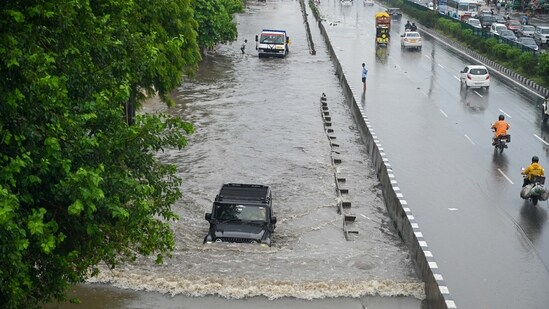
However shocking, these scenes now evoke a feeling of déjà vu. In the last two decades since the Mumbai flood, caused by a 100-year-high rainfall and killing more than 1,000 people in 2005, there has been no respite for Indian cities from inundation, monsoon after monsoon.
Experts say there is no quick fix for flooding triggered by short bouts of intense rain due to climate change. While such events will continue to overwhelm the civic infrastructure, which has its physical limits and capacities, there is little excuse for not doing the basics right, which go a long way in monsoon preparedness.
Predicting an uncertain climate future is often challenging, but looking back at how we have planned, designed, and maintained our cities can offer vital cues for course correction.
Lessons from urban ‘development’
{{/usCountry}}Lessons from urban ‘development’
{{/usCountry}}When the British decided to move the imperial capital from Calcutta (Now Kolkata) to Delhi, the architects were reluctant to go with the earmarked Coronation Park site in Burari because it was too close to the floodplain. Ultimately, the higher ground on Raisina Hill was selected. Ironically, much of the urbanisation post-Independence has happened in the floodplain, which naturally attracts floodwaters.
Chennai, which is frequently inundated — its worst floods were reported in 2015 — does relatively better in the planned old town, where the drains are still functional, said Balaji Narasimhan, a hydrologist at the Indian Institute of Technology (IIT) Madras. The hotspots are low-lying areas developed on paddy fields where the soil is clayey, water cannot percolate freely, and drainage by gravity is limited due to topographical constraints and encroachment of drainage pathways.
In Mumbai, the land reclamation areas, including parts of Island City and Bandra Kurla Complex, are more prone to waterlogging. “These low-lying areas are challenging to deal with. If high tide is coupled with high-intensity rainfall, water takes more than normal time to recede and accumulate,” said Abhijit Bangar, deputy municipal commissioner (projects) at Brihanmumbai Municipal Corporation (BMC).
Rainwater is meant to take its natural course, flowing from upstream to downstream and falling into a lake, river, or sea or sinking back into the earth. However, when linear infrastructure such as rail tracks, roads, or buildings intercept this natural flow or concrete surfaces prevent absorption, flooding occurs. Delhi, for example, has raised pillars of elevated roads and the Metro inside its natural channels that once facilitated rainwater drainage to the Yamuna.
Previously, cities would flood from swollen rivers. Now we see “in-situ flooding”, said Depinder Kapur, the head of the Climate Centre for Cities at the National Institute of Urban Affairs. “During heavy rains last year, the water levels in the Yamuna did not rise, yet south and central Delhi were inundated. Even Bengaluru, located on a plateau with no major river, suffers from frequent in-situ flooding. Increased precipitation plays a big part here, but this also highlights significant issues in urban planning.”
Obsessive overbuilding
Across cities, there has been a mindless tendency to overbuild. Using high-resolution satellite imagery, WRI-India found that between 2000 and 2015, the built-up area in the ten most populous Indian cities increased on average by 47% and 134% within 0–20km of the city centre and 20–50km periphery, respectively.
Simultaneously, the blue cover (water bodies) decreased by 15%. The study also found that 44% of this new development is located in zones with high or very high recharge potential, and an estimated 300 billion litres of water per year are now diverted away from underground aquifers.
A US-specific study indicates that even a 1% increase in built-up areas results in a 7% increase in the extent of flooding. In India, this is partly because of market pressure to get the maximum value from the land, said Sahana Goswami, senior programme manager at WRI-India, one of the authors of the 10-cities study.
There is also the desire to have good views — such as lakeside and riverside apartments — where development occurs at the expense of green and blue spaces. Regulations on land use need to be implemented, added Nitin Bassi, who leads the sustainable water team at Council on Energy, Environment and Water (CEEW), a non-profit policy research institute.
In-built inadequacies
Many cities have common channels for stormwater and sewers. In Bengaluru, nullahs are losing their natural slope because stormwater channels are used as sewer drains throughout the year.
With siltation, the water stagnates, receding the slope gradient. Also, culverts with their pillars reduce the width of the drain, said Rajarshi Das Bhowmik, assistant professor at the Indian Institute of Science (IISc) Bangalore.
In extreme cases of flooding, roads are also supposed to serve as conduits for water. But if roads are not milled to the bottom when relaid, it artificially changes the road profile as compared to the adjacent lands, and causes localised flooding, said Narasihman.
Indian cities don’t have a separate utility duct to put water supply lines, power lines, data fibres, etc. They use the storm drain as an easy conduit, he added.
If the older cities suffer from legacy drainage issues, the newer towns have grown without the basics.
Gurugram rose from agricultural lands sold to builders who developed private gated communities on a level higher than the surrounding roads, said Bassi. these gated complexes set up decentralised wastewater management without factoring in the high runoff volumes they would release to the streets during storm events, he added.
The newer areas of Bengaluru have similar problems. Wastewater is often dumped outside the gated society, which remains flood-free, but the road outside is inundated, said Bhowmik.
Multiple jurisdictions of drains compound the problem. In Delhi, nine agencies are involved in drain management. “If the flood and irrigation department drains are not clean, the water from the public works department will backflow. When the PWD drains are blocked, the MCD drains backflow,” said a retired official at the Delhi Municipal Corporation.
Seasonal mess
Indian cities prepare for the monsoon mess throughout the year by dumping tonnes of garbage, construction waste, and domestic sewage into stormwater channels. Before the monsoon, the road-owning agencies clean these choked drains, leaving them on the roadside. The first shower, and the muck is back in the drains.
On average, about one million metric tonnes of silt is removed from the drains annually in Delhi, but there is no dedicated disposal space. Landfills are saturated. “It is anybody’s guess where the silt goes,” said the retired official.
While silt removed from the nullah is supposed to be carried for disposal, there is a reason desilted muck is left lying in the open for at least 48 hours. “It is to dehydrate it. Wet silt can’t be carried immediately, as it leads to problems of leachate leakage from the transport vehicles. Wet silt also adds to the weight-to-volume ratio and can lead to excessive payments to contractor payments,” explained Bangar.
But can desilting alone ensure that rainwater won’t flood our cities? Not really, said Goswami. “We assume the drains have 100% coverage. Also, many parts of our cities have combined sewers, or what was originally a storm drain now carries sewage anyway. This high volume of mixed silt accumulating daily must be removed to ensure effective storm drains.”
In Gurugram, even if the drains are there, they are inadequate to take care of the road runoff. Then there is additional water from the flyovers, which finds no way to evacuate and cascades like a waterfall to the road below, said Bassi.
Municipal officials feel that too much accountability has been placed on agencies without adequate support. “They talk about geo-tagging the desilted sites, but during the three months we do the job, there is a shortage of machinery, trucks, loaders, etc, which nobody talks about. The plans to mechanise the work are still on paper,” said the former MCD official.
Bassi concurs: “Municipalities manage too many things simultaneously, but their finances are poor. Municipal services — water supply, free solid waste collection, park maintenance — cannot be free anymore. They need to be priced to generate enough resources for the municipalities to work as required.”
Nature-based solutions (NBS)
Goswami said we can preserve excess water as a resource; only what can’t be absorbed should go downstream. So, efforts are being made to revive many natural water bodies surrounding Bengaluru. In Chennai, the marshland that used to absorb floodwater is being rehabilitated.
But, NBS is not without its limitations, said Narasihman. “The sponge park might only work in two-year or five-year floods. If the flooding exceeds that, the city will still be inundated.” But, NBS has other co-benefits of reducing urban heat island, and helping groundwater recharge and biodiversity, he added.
NBS are also not maintenance-free, as natural drains require dredging and sponge parks must be revegetated. Most importantly, agencies in charge must ensure that rainwater polluted with sewage, garbage, and road runoff doesn’t land in these water bodies and green spaces without proper treatment. The efficacy of runoff absorption also depends on the water table and may not work where the groundwater levels are high, warned Bhowmik.
Bangar said that in cities like Mumbai, where every square inch of land is extremely valuable, there is no space for NBS apart from government land, forest land, the national park, and salt pans. “This has prompted us to design NBS considering existing gardens and grounds. Mangroves and salt pans can also act as great detention and retention areas for flood water,” he said.
Unpaving the paved
Many people who live in low-lying areas are from disadvantaged communities. They have built their lives around these locations. Goswami looked at this as a political problem: “Instead, why don’t we consider the interim retrofit solutions and make them equitable?
Flooding often occurs in urban areas because stormwater flows across the city. This water needs to be absorbed locally, ideally in greenbelts or parks, but that is not possible if these areas are heavily walled off. In a 2010 survey, municipal officials identified at least 300 neighbourhoods that did not have issues with sewage discharge, which could have been used for recharging water in local parks. However, according to the MCD official, no action was taken.
Ultimately, it has to be a combination of solutions. “The CSE study in Sangam Vihar –– Delhi’s largest unauthorised settlement, housing an estimated one million people, confirmed the need for a blend of grey and green-blue infrastructure under a decentralised water supply, wastewater and stormwater management. If we want to address equity and justice, then we must prioritise the deficits in our dense unplanned settlements,” insisted Kapur, who authored the study in his previous role at the Centre for Science and Environment.
Going forward
Goswami suggests hydrological mapping of cities to understand how water flows on the surface and through the drainage network, and streamlining the financing and tendering processes and protocols to operationalise NBS.
Mumbai is working with IIT Bombay to develop a flood management plan, which Bangar said would combine hardware and nature-based solutions, even as upgrades in drainage and pumping stations are underway.
In the neighbouring Thane district, CEEW has studied the city’s rain data for the past 52 years, socioeconomic factors, and satellite information for hotspot analysis under the action plan for flood-risk management launched last year.
Bengaluru’s solution
In the IT city, the Tender S.U.R.E specifications for urban roads include a “pipe and chamber” system to replace the conventional RCC box storm drains, which lack gradient, cannot be rectified once constructed, and either backflow or stagnate. The loose slabs covering them are a walking hazard.
The new model with precast pipes minimises human errors and makes it easier to maintain slopes chamber to chamber, allowing for speedy evacuation while preventing backflow, said Nithya Ramesh, director of urban design at Jana Urban Space Foundation, which pioneered Tender S.U.R.E.
The drains are located right at the edge of the travel lane, where the water drains faster. The inlets at every chamber have metal gratings that filter solid waste. They can be built without disrupting traffic and eliminating the requirement for catch pits and connecting pipes.
Ramesh said this is an easily scalable solution that can be retrofitted into any road with pipe diameter variations based on the area’s rainfall and catchment. These drains are part of the 100-km Tender S.U.R.E roads in Bengaluru and 20km in Hubballi–Dharwad. Another 85kms is under construction across 17 cities in Uttar Pradesh.
Kolkata goes back to basics
Kolkata, long known for its flooded streets, is implementing a drainage overhaul. The city’s brick sewer system, installed by the British in 1884, consists of combined drains carrying waste and stormwater. Tarak Singh, a member of the mayor-in-council in charge of drainage at Kolkata Municipal Corporation, said regular cleaning, repairs and upgrades are necessary, regardless of Kolkata’s bowl-like topography.
Previously, drains were believed to handle only 6mm of water discharge per hour. Singh said desilting was done under hazardous conditions, leading to time lags and mismanagement. Since 2015, funding from the state government has allowed the purchase of high-powered jets and suction machines.
In the past decade, two million metric tonnes of silt have been removed, and new linings have been installed to prevent leakage. This has enhanced the capacity of the drains, said Singh.
The number of pumping stations increased from 74 to 82, and the number of functional pumps, vital for draining water to the river, jumped from 365 to 460.
During high tide in the Hooghly, the lock gates are closed, which also blocks the water accumulated from the rain. Earlier, it would take days for the water to recede in the rainy season because of silted sewers and broken pumps. With ongoing desilting, Singh said, water evacuates much faster now.