Mammoth Cave is widely recognized as the longest known cave system on Earth, with more than 426 miles of mapped passages. But the more surprising story is what happens outside the cave. Rain miles outside the park boundary can soak into the ground and run through hidden passages before showing up inside the cave itself. For decades, hydrogeologists Chris Groves, Joe Meiman and Shannon Herstein have tracked exactly how this hidden water network behaves in research published in the U.S. Geological Survey Karst Interest Group Proceedings.
How dye tracing maps water no one can see
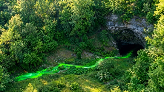
You can’t see the groundwater moving. It moves through cracks and veins far under the ground, out of sight. So scientists have devised a clever workaround: dye tracing. They pour a harmless bright dye into a sinkhole or stream that disappears underground and then watch nearby springs to see where the dye reappears. According to the U.S. Geological Survey, the technique allows researchers to trace the movement of underground water and discover the source of water used in that area for drinking purposes. Since 1999, the WKU-led team has conducted a long-term dye tracing program at Mammoth Cave to map these routes accurately.
The cave water map goes far beyond the park
Much of the water flowing through the Mammoth Cave aquifer comes from outside the park altogether. Several of the underground basin boundaries are in nearby urban and transportation corridors, places where a spill or a leak could travel underground to reach the cave's springs, the Groves, Meiman and Herstein study notes. Thus, the park’s water quality depends heavily on land outside the park’s control, and this is why continued dye trace work is so important. It’s not as academic and more of an early warning system for pollution.
{{/usCountry}}Much of the water flowing through the Mammoth Cave aquifer comes from outside the park altogether. Several of the underground basin boundaries are in nearby urban and transportation corridors, places where a spill or a leak could travel underground to reach the cave's springs, the Groves, Meiman and Herstein study notes. Thus, the park’s water quality depends heavily on land outside the park’s control, and this is why continued dye trace work is so important. It’s not as academic and more of an early warning system for pollution.
{{/usCountry}}Karst water isn't just a Kentucky problem
All of this might sound pretty niche, but karst landscapes like this are not uncommon. The National Cave and Karst Research Institute estimates that between 10 and 20 percent of the world's land surface is karst terrain, and a large proportion of the world's population depends on karst aquifers for drinking water at some point in the water's journey, according to NCKRI's own public research materials, with independent estimates putting the global population figure as high as 20 to 25 percent. That includes parts of the United States, as well as regions in Asia, Europe, and the Americas. Mammoth Cave is a clear example of hidden dangers, which are present all around us but go unnoticed until it’s too late. If you live over limestone, your tap water may also move through hidden underground pathways. Learning how the Mammoth Cave system works can help researchers protect groundwater far beyond Kentucky.
What researchers still need to map
The dye tracing program has not stopped. Many regional basin divides are only approximately defined even after hundreds of individual traces have been completed over decades, especially in areas under development pressure, as stated in the Groves, Meiman, and Herstein paper. With each new trace, researchers add another piece to the puzzle, helping protect the underground ecosystem and the people who depend on it.
Mammoth Cave is famous for its size, but its real lesson might be a little simpler. It shows us how much we are all connected to the earth beneath our feet, and how far that connection can reach.