A mountain damaged by an earthquake eleven years ago. A glacier that had retreated from the rock wall it once held in place. Melted ice water inside the cracks running through the rock. Rain falling where snow used to. And a stretch of unusually warm days.
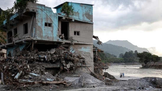
A scientific assessment of the disaster that struck Nepal's Bhote Koshi and Trishuli valleys on August 26 does not identify a single cause of the avalanche-flood. It sets out a chain of factors, each acting over a different span of time, which likely helped bring down 110 million cubic metres of rock and ice from Langtang Lirung peak.
"While this is a complex event, our analysis brings together scientists with a diverse range of expertise to set out the factors that likely contributed to this catastrophe," said Ben Clarke, extreme weather and climate change researcher at Imperial College London and lead author of the analysis.
Clarke added, "We found that climate change is transforming the high mountain environment influencing many of the possible drivers of this collapse. This increases the risk in a region that is already exposed to high seismic activity."
The analysis, published on Thursday by World Weather Attribution (WWA), found that decades of rising temperatures had thinned the glacier propping up the rock and thawed ice that had kept together the fractures inside it.
{{/usCountry}}The analysis, published on Thursday by World Weather Attribution (WWA), found that decades of rising temperatures had thinned the glacier propping up the rock and thawed ice that had kept together the fractures inside it.
{{/usCountry}}Also read: A collapse 5,200m high, bodies swept up to India & a lake overflowing
"There's absolutely no doubt that human induced climate change played a role here in the preconditioning of the disaster through permafrost thawing, through thinning of the glaciers, through having more rainfall instead of snow," Friederike Otto, a climatologist at Imperial College London and one of the report's authors, told Reuters.
The study does not say warming of the planet caused the collapse, but it concludes that climate change acted as a destabilising force on a slope that was already geologically predisposed to fail, and which the magnitude-7.8 earthquake of 2015 had possibly weakened.
The death toll for the August 26 floods was 1,386, as of September 12, and another 5,130 people were reported missing, according to data by Nepal's National Disaster Risk Reduction and Management Authority (NDRRMA). The government has estimated the disaster's economic impact at $2.7 billion, and the cost of recovery and reconstruction at $4.8 billion, equivalent to 6.7% and 11.8% of the country's GDP.
WWA is an international scientific collaboration that assesses the possible influence of climate change on extreme weather events. The team behind this analysis included scientists from Nepal, the UK, Ireland, Sweden, Denmark, Norway, the US, New Zealand, Pakistan and the Netherlands. Kathmandu-based researchers from Climate Analytics South Asia were among the authors, and the Nepal Red Cross Society among the reviewers.
Also read: ‘Everything, everyone is gone’: Mapping the glacier collapse that devastated Nepal and Tibet
The avalanche and the flood
Satellite analysis indicates that roughly 2.2 sq km of the northern face of Langtang Lirung, about 50 metres deep, detached at an elevation of around 5,150 metres. The rock gave way first, bringing a section of the glacier sitting above it down at the same time.
It fell about 1,400 metres to a valley floor at 3,750 metres. The impact released energy equivalent to a magnitude 5.2 earthquake, which is why seismic monitors initially logged the event as a tremor. Collapses on this scale are rare. The study puts the frequency at roughly one event of this size every 1,000 to 10,000 years.
Friction generated as the mass travelled down the mountain probably melted some of the glacier ice, it said. At the valley floor, the avalanche also struck buried ice left behind by the retreating glacier, adding up to 30 million cubic metres more debris and water to the flow.
By the time it entered the Lhende Khola river, the mass had transformed into a fast-moving debris flood, funnelled downstream through a narrow gorge. It covered roughly 20km to the Gyirong border crossing with Tibet in seven to eight minutes, and hit the river confluence there with enough force to push water 2km back upstream into Chinese territory.
The flood deposited 30.5 million cubic metres of sediment and debris along the corridor, burying farmland, settlements and hydropower plants. At Galchhi, 88km downstream, the Trishuli river rose 8.5 metres.
Also read: 19-member team from India begins DNA testing in Nepal
A mountain already weakened
The April 25, 2015 Nepal earthquake triggered more than 25,000 landslides across central Nepal that day, among them a rock-and-ice avalanche from the southern face of Langtang Lirung, which buried the village of Langtang and killed up to 400 people.
Long-term monitoring in the decade since has found that land-sliding on both the northern and southern slopes of the mountain has kept increasing, the study said, citing surveys of the region. By the end of 2018, landslide rates in the area were higher than they had been the day after the earthquake. Across the earthquake-affected region, slopes above roughly 4,500 metres have shown rising rates of landslides while lower slopes have generally settled, the surveys found.
Mountains do not shake evenly in an earthquake. Ridgelines shake harder than the valleys below them, and the slope that collapsed last month is near a ridgeline in an area that recorded some of Nepal's strongest ground motion in 2015.
The researchers said they cannot conclusively determine the earthquake's role in weakening this particular slope, but that several conditional factors suggest it may have played one.
"We conclude that this was a geologically vulnerable slope, potentially weakened by the 2015 earthquake, but it was destabilised further by glacier and permafrost retreat and by the excessive meltwater and exceptional warmth in the final period before the collapse," Walter Immerzeel, a mountain hydrologist at Utrecht University and one of the report's authors, told Reuters.
What warming did over decades
Ice inside the rock melted. Permafrost, ground that stays frozen from one year to the next, fills fractures in high rock faces and bonds them together. As that ice warms towards melting point its strength depletes. Once it melts, the bonding can be partly or completely lost, and the water it produces migrates deeper into the fracture network.
Warming is pushing that frozen layer higher up the mountains, and the collapse occurred in the band where Nepal's permafrost is thinning fastest.
Jakob Steiner, a geoscientist at the University of Graz who has worked in the Himalayan region since 2006 and was not an author of the report, told the Associated Press that instruments at around 5,000 metres now show some rock and ground no longer staying frozen throughout the year. "This means that the ground that was sitting below ice for hundreds and thousands of years is now becoming exposed," Steiner said.
The glacier that propped up the rock wall retreated. Glaciers press against adjacent rock walls and hold them in place. The Langtang-Lirung glacier covered 18.9 sq km around 1815 and had shrunk to 7.34 sq km by August 24 this year. The loss of area was slow and steady until it accelerated after 2010, according to the study's mapping of satellite imagery. This is driven primarily by rising temperatures, the researchers noted.
The retreat had left the glacier perched above a steep rock face, the study said, with broken pieces of ice further down the valley.
More rain fell where snow used to. Rising temperatures push the rain-snow transition up the mountain. Typically, snow settles on the surface and melts slowly, while rain soaks straight into the cracks in the rock and pushes them apart.
On this, researchers found no clear link to climate crisis, but noted that rainfall increased and snowfall decreased during the monsoon months in the region over the past two decades. Confirming that shift will need further analysis, the study said.
Bethan Davies, professor of glaciology at Newcastle University and one of the report's authors, said the warming caused by burning fossil fuels is melting ice and snow across the Himalayas, reducing glacier coverage and thawing permafrost.
"This is destabilising the mountain sides and leading to an increase in disasters like this one," she said, adding: "Urgent action is needed to cut emissions in order to avoid an even faster melt and a greater risk of future disasters."
The weeks before
The conditions immediately preceding the collapse may have been factors too.
July and August 2026 were the warmest such months recorded locally, according to the analysis.
On August 24 and 25, daily mean temperatures at the site of the collapse reached about 5.3°C to 5.4°C, against a 2016-2025 reference of roughly 2.7°C to 2.8°C. The maximum temperature on August 23 to 25 reached 11.3°C to 12.6°C, compared with a normal of 5.5°C to 6.0°C. August 25 recorded mercury about 7°C above the normal. And every hourly temperature recorded between August 12 and 26 stayed above freezing.
Separately, stations recorded exceptionally high precipitation in October and early November 2025, much of it falling as snow. Where that snow persisted, its melting through the following spring and monsoon could have supplied large volumes of water to the catchment, the researchers said.
The region is warming
Across the wider Himalayan region covering parts of northern Nepal and the Tibetan plateau, July and August are now about 1.5°C warmer than in pre-industrial times, and mean annual temperature about 2.0°C warmer, the study found, attributing both to human influence on the climate.
The altitude at which ice melts has moved up by 50 to 100 metres a decade in the warmest seasons of the year, exposing rock and ice that used to stay frozen. The energy available to melt ice has grown steadily since 1980, and probably faster over the past ten years. Every month of the year is warmer than it was, with the coldest months warming fastest, at two to three times the global rate.
The researchers did not assess whether the August 26 rock-ice avalanche would have happened in the absence of human-induced climate change. But the study said that climate crisis was driving a rapid transformation of high mountain environments across the Himalayas, raising the risk of disasters and that this threat would only keep growing until emissions were drastically cut world over.
A warning may not have been enough
Researchers said the event was fundamentally different in magnitude, speed and complexity from the riverine floods that Nepal's warning systems were built to forecast.
"It was beyond the design and predictive limits of existing risk reduction measures, and no existing early warning system could have provided sufficient lead time or prevented the scale of impacts observed in the worst-affected areas, highlighting the limits of adaptation," the analysis said.
Even if a system had detected the initial slope failure and issued an immediate alert, people furthest upstream at Rasuwagadhi and Timure would have had seven to eight minutes to evacuate. That would have been valuable in some cases, the study said, but by and large would not have been enough time for the scale of evacuation needed to prevent devastating loss of life.
"Communities in Nepal are paying with their lives for a crisis driven by fossil fuel emissions thousands of miles away," Otto told The Guardian, adding: "When warming destabilises the roof of the world, no amount of local adaptation can fully shield vulnerable people downstream from this scale of destruction."