...
...
Next Story

Rock, paper, fissures: Answering questions around the ‘new’ continent of Zealandia

Updated on: Feb 3, 2024, 14:56:34 IST
By
Prefer HTon Google
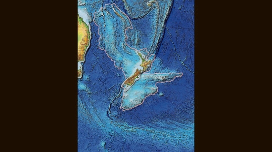
PREMIUMThe topography of Zealandia, outlined in pink. (Wikimedia Commons)
The topography of Zealandia, outlined in pink. (Wikimedia Commons)
Advertisement

See how it twisted away from Gondwana, caught fire and sank. Was missed and then mislabelled. And is now being studied for clues on life in the dinosaur age.

Continents are a lot like people. They drift about, break old bonds, develop new ones, go around in circles.

There was, of course, the great joint family, Pangea, about 299 million years ago, when almost all the land on Earth was a single fertile mass. In about 250 million years, all the continents will likely fuse again.

What’s interesting, in the present, is that we are still discovering what happens when continents split. Proof of this lies in the recently

. (GNS Science)

What made Zealandia sink?

The mapping has revealed that the crust, in some places, is just 10 km thick, which, geologists say, could account for why much of it remains underwater. Most continents have a crust about 40 km thick across most of their area.

The only portions of this one visible above water are New Zealand, New Caledonia and the Australian territories of Lord Howe Island and Ball’s Pyramid, making it the only continent on Earth where far more surface area is submerged than is visible.

What made it so thin?

By 2023, researchers from GNS Science had studied rocks dredged up from the crust and formed a picture of Zealandia’s early years.

Giant volcanic regions typically erupt as supercontinents split, Mortimer says. A well-known example is the Deccan Traps, large parts of present-day Maharashtra, Gujarat, Goa, Madhya Pradesh and Rajasthan that were covered in lava, as India and Africa tore away from each other.

Here, a rift in southeast Gondwana birthed the Tasman Sea, which sits between Australia and New Zealand. Another rift led Zealandia to split from West Antarctica. A giant volcanic region, the size of New Zealand itself, then emerged between Zealandia and Antarctica, between 100 and 60 million years ago.

For about 40 million years, as magma flooded out of cracks and fissures, Zealandia stretched and thinned “like pizza dough”, Mortimer has said.

This activity eventually ceased, Zealandia cooled, and as its thin crust solidified, it sank.

The Australian territories of Ball’s Pyramid and Lord Howe Island.

But… but…

Numerous questions remain. Why did the thin ribbon not crumble, as the Seychelles microcontinent did? What flora and fauna lived on it before it sank? Could the rocks hold revelatory fossil remains?

“We are satisfied at the moment to have put Zealandia on the map,” Mortimer says. But as the youngest continent is studied further, he admits, it is likely to throw up more surprises.

All Access.
One Subscription.

Get 360° coverage—from daily headlines
to 100 year archives.

E-Paper
Full
Archives
Full Access to
HT App & Website
Games
 
Explore the latest Lifestyle News on health, fashion, travel, relationships, food and festivals. Find useful tips, expert advice, trends and inspiring stories for everyday living.
SHARE THIS ARTICLE ON