Himachal Pradesh to come up with hill-cutting policy, prompted by the rise in landslide incidents across the state and the need for stricter development norms.
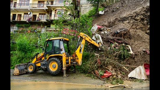
Special secretary, disaster management, Pushpendra Rana, said that the state government had drafted a Hill Cutting Policy aimed at regulating construction and development activities in vulnerable hill areas. The policy is currently under examination by the law department, he said.
“The basic objective is to minimise unnecessary hill cutting and ensure that development follows the natural profile of the hill. Natural drainage systems have to be protected, slopes need to be stabilised and excavated material and muck must be stored or dumped safely,” Rana said on Wednesday.
He said the policy would also seek to fix accountability for safe and scientific construction practices.
“Development cannot be stopped, but it has to be made safer. The responsibility for scientific construction, slope stability, drainage and safe disposal of muck has to be clearly fixed,” he said.
“We need a balance between development and environmental conservation. The answer is not to stop development, but to ensure that development takes place according to the carrying capacity, geology and disaster vulnerability of the area,” he said.
Rana said the government was therefore working towards a more integrated approach involving disaster management, scientific assessment, early warning systems, land-use planning and stricter construction norms.
{{/usCountry}}Rana said the government was therefore working towards a more integrated approach involving disaster management, scientific assessment, early warning systems, land-use planning and stricter construction norms.
{{/usCountry}}State witnessed over 4k landslides in 2025
Satellite-based rapid damage assessment has mapped 4,644 landslide events across the state during the May-September 2025 monsoon, providing a detailed picture of the scale and geographical spread of slope failures.
The findings, published in Surakshit Sansar, published by the International Institute of Security and Safety Management (IISSM), focus on security, safety, disaster management, climate resilience, and public welfare topics.
The study is based on multi-temporal Sentinel-2 satellite imagery analysed using Remote Sensing and Geographic Information System (GIS) technologies. The study was authored by disaster management specialists Ritesh Kumar, Neha Thakur and Pushpendra Rana.
Rana said that a recent analysis of satellite data had identified 6,494 landslide locations across the state between 2018 and 2025, with around 4,600 locations detected in 2025 alone using Sentinel-2 satellite imagery. During the current monsoon season, 36 major landslide incidents have been reported in the state, with a significant number occurring in Lahaul-Spiti and Kullu districts, he said.
“The recent data on landslides is alarming. The increasing number of landslide locations shows that we need to seriously look at the way development is taking place in the hills. SDMA will take the lead in ensuring that development norms are made more scientific and suited to the fragile Himalayan terrain,” Rana said.
He said landslides in Himachal Pradesh could not be attributed to rainfall alone, as the state’s geology, steep topography, terrain and increasing frequency of extreme weather events also played an important role.
“The Himalayas are a young and fragile mountain system. Landslides are not caused only by rainfall. Geological formations, topography and the nature of the terrain are equally important factors. Extreme events such as cloudbursts and flash floods further increase the vulnerability,” he said.
Rana said recent incidents in neighbouring Himalayan regions, including Nepal, had also highlighted the need for greater preparedness and scientific planning across the Himalayan belt.
Landslide risk mitigation funds
Rana said the state had received ₹39 crore as the first instalment of the ₹139-crore allocation under the National Landslide Risk Mitigation Scheme.
In collaboration with CSIR-CBRI, Roorkee, early warning systems are being established at 18 high-risk landslide locations across the state.
He said such systems would help authorities detect developing risks and provide timely warnings to vulnerable communities.
The SDMA has also prepared hazard risk zonation maps, which are intended to assist government departments in planning infrastructure and development projects in accordance with the disaster vulnerability of different areas.
“Hazard risk zonation is an important tool for deciding where and how development should take place. Departments need to factor disaster vulnerability into infrastructure planning rather than responding only after a disaster occurs,” Rana said.