The Uttarakhand government plans to conduct a multi-disciplinary survey of disaster-prone areas on the Char Dham route to avoid Gaurikund-like incidents, a senior official said.
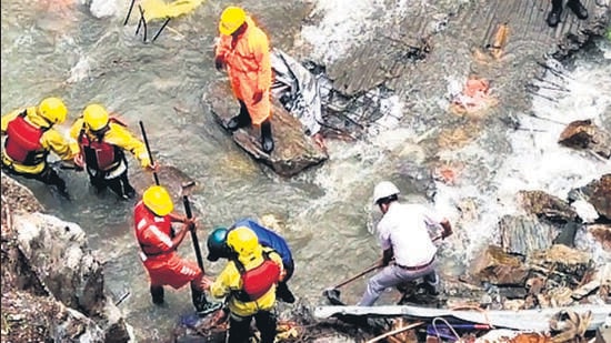
“A multidisciplinary survey, involving dimensions such as geology, road safety, and risk assessment, will be carried out with regard to disaster vulnerability on the Char Dham route. We have approached subject experts but the date for the introductory meeting is yet to be decided. The modalities will be finalised after the meeting,” said the state’s additional secretary, disaster Management Suvin Bansal. State disaster management secretary Ranjit Kumar Sinha visited the landslide-hit site in Gaurikund on Saturday.
A senior official of the disaster management department who didn’t wish to be named said the state could restrict construction (of any kind) in areas prone to landslides and climate events as identified by the survey.
“The Gaurikund incident has put a spotlight on illegal construction on the Char Dham route in recent years. Old constructions will be removed from the disaster-prone areas and no new constructions will be allowed,” he added. The Rudraprayag district administration on Saturday removed around over two dozen shops set up illegally in landslide-prone areas along the Kedarnath track and pledged to initiate similar action against all such constructions.
HT on Friday reported the mushrooming of shops along the Kedarnath route has taken place despite Rudraprayag and Tehri Garhwal being among the districts to have the highest landslide density according to a satellite-based study of 147 vulnerable districts by the National Remote Sensing Centre (NRSC) in March 2023.
Three bodies were recovered and 20 people are still missing after a landslide triggered by heavy rain-hit Gaurikund, which is the commencement point of the Kedartnath yatra route, on August 3 night. Search teams on Monday continued to trace the 20 missing people who fell into the strong currents of the Mandakini river. The search is being carried out at various locations downstream, using underwater sonar system and other possible means like drones.
{{/usCountry}}Three bodies were recovered and 20 people are still missing after a landslide triggered by heavy rain-hit Gaurikund, which is the commencement point of the Kedartnath yatra route, on August 3 night. Search teams on Monday continued to trace the 20 missing people who fell into the strong currents of the Mandakini river. The search is being carried out at various locations downstream, using underwater sonar system and other possible means like drones.
{{/usCountry}}Anoop Nautiyal, a Dehradun-based social activist, said, “It’s a lethargic and reactive action to order such a survey and reflects the horrendous disaster mismanagement in the disaster-prone state. If they would have not allowed the construction along the Yatra route in the first place, this incident would have never happened. “
The spot where the incident occurred is around 50 metres from the Char Dham road. The Char Dham road ends at Gauri Kund from where 16 km trek to Kedarnath Dham starts. Experts have raised concerns about the condition of the Char Dham all-weather road, especially in Rudraprayag and Chamoli districts. On both roads, construction debris, fallen rocks on the roads, create traffic bottlenecks, allowing only one vehicle to pass at a time at many stretches. Side railings and crash barriers, essential for driving safety in the hills, have been buried under debris on many stretches in both districts. A note submitted by Centre before Supreme Court in November 2021 mentions 125 vulnerable locations with respect to landslides on Char Dham all-weather road, including 14 locations on the Rishikesh-Rudraprayag stretch and 9 on the Rudraprayag-Gaurikund stretch.
Nautiyal said he was not hopeful of the survey since findings of such surveys are never implemented on the ground given the state’s track record.