Heavy rainfall pounded Tamil Nadu's Chennai as the northeast monsoon intensified, triggered severe waterlogging and traffic congestion in several parts of the city.
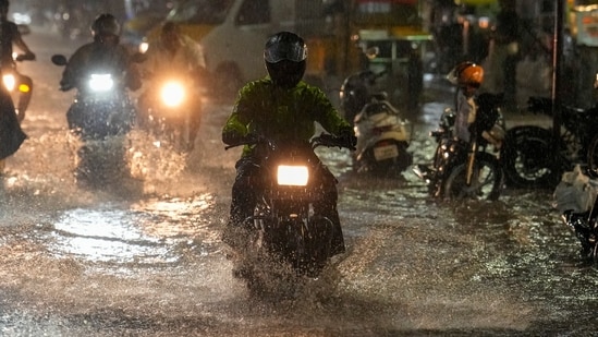
The rain continued through the night up to Sunday morning, causing flooding of several roads across the city, particularly in North Chennai, where it became difficult for the residents to commute.
North Chennai bore the initial strain of the showers, recording between 6 cm and 10 cm of rainfall in less than an hour. Videos shared by news agencies ANI and PTI display heavy rains and flooding in the city and residential areas. Chennai locals also shared videos on X expressing agitation over the weather.
Also Read | Southwest monsoon withdraws from entire country: IMD
One X user shared a view of Chennai airport enveloped in heavy rain, showcasing light flooding on the ramp.
{{/usCountry}}One X user shared a view of Chennai airport enveloped in heavy rain, showcasing light flooding on the ramp.
{{/usCountry}}Chennai steps up preparedness
The flooding has prompted civic authorities in Chennai to step up preparedness. More than 15,000 sanitation and other civic workers were deployed across the city overnight to clear flooded roads, manage waterlogging and respond to complaints. The Tamil Nadu State Disaster Response Force also deployed 100 personnel as a precaution, with National Disaster Response Force and State Disaster Response Force teams being mobilised to assist if conditions worsen.
Also Read | Mercury drops in Delhi after rainfall, AQI down to ‘satisfactory’ level
Northeast monsoon intensifies
The heavy rainfall follows the onset of the northeast monsoon over Tamil Nadu, which started on October 17, according to IMD. The northeast monsoon (often called the winter or retreating monsoon) is a seasonal wind and rainfall pattern that occurs from October to December in the South Asian peninsula. The seasonal rain is particularly significant for Tamil Nadu, which depends heavily on the northeast monsoon for its annual rainfall.
The showers were triggered by a cyclonic circulation over north Tamil Nadu and coastal Andhra Pradesh, along with a trough stretching from Lakshadweep towards the southwest Bay of Bengal.
Heavy rainfall to continue
The IMD has issued a yellow alert until 23 October, with very heavy rain lasting until 21 October, across the state. A yellow alert means heavy rainfall between 6 cm and 11 cm. Flooded roads may lead to prolonged traffic congestions, particularly in low-lying areas.
Meteorologists forecast that widespread rainfall will continue across several districts -- Chennai, Chengalpattu, Tiruvallur, Kancheepuram, Villupuram, Cuddalore, Mayiladuthurai, Nagapattinam, Thanjavur, Tiruvarur, Pudukkottai, Ramanathapuram, Sivaganga, Thoothukudi, Kallakurichi, Ariyalur, Perambalur, Tiruchirappalli, Nilgiris, Coimbatore and Tirunelveli.
Heavy showers could lead to temporary waterlogging, slower traffic and disruption to daily activities, particularly in locations with poor drainage.
The RMC has issued an advisory on X regarding Do's and Don'ts for severe thunderstorm-like conditions, highlighting preparations and responses for different situations, including what one should do if struck by lightning. Residents are advised exercise caution while travelling through waterlogged areas and avoid crossing flooded roads. People should also take shelter indoors during thunderstorms and stay away from exposed locations during lightning activity.
(With inputs from PTI)