When the Dust Bowl choked the American prairies in the 1930s, the US government tried something nobody had attempted at that scale before: planting rows of trees across the Great Plains to hold the soil down. According to a study published in Built Heritage, the Prairie States Forestry Project saw more than 200 million trees planted across 33,000 shelterbelts between 1935 and 1942. Roughly 80 years later, many of those same tree lines are still standing on working farms today.
A New Deal answer to a man-made disaster
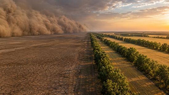
The Dust Bowl was more than just bad weather. Decades of plowing up the native prairie grass had loosened the topsoil, and when the drought came, the wind blew it away in dark, choking clouds. President Franklin D. Roosevelt backed the plan to plant tree belts to slow that wind and save farms. The project was overseen from Lincoln, Nebraska, by Forest Service administrator Paul Roberts, who worked directly with thousands of landowners willing to plant trees on their property in exchange for free seedlings and guidance.
Just how big was this planting effort
The study notes that the shelterbelt plantings covered 18,600 miles across six different states, running from the Texas panhandle to North Dakota. According to the National Register documentation housed in Nebraska, which covers the project's federal records and is cited in the same study, a more precise count puts the total at more than 220 million trees planted in shelterbelts from North Dakota to Texas, a somewhat higher figure than the study's own general estimate of 200 million, reflecting the difference between a broad estimate and a more detailed federal tally. Whatever the number, it is one of the largest tree planting efforts in the history of the United States, carried out with voluntary cooperation with private farmers.
How much of it is still there?
To find out what survived, University of Nebraska-Lincoln researchers digitized more than a thousand archival township maps and overlaid them on contemporary aerial photographs. The researchers report that this process mapped 10,022 individual shelterbelts planted in 62 Nebraska counties from 1935 to 1942. As of 2016, the results were surprising: 40 percent of the survey was made up of fully intact shelterbelts, another 36 percent were partially intact shelterbelts, and only 24 percent were gone. Antelope County in northeastern Nebraska had the most shelterbelts planted, with 1,201. This Nebraska-focused survival rate blew away decades of assumptions that most of these old plantings across the Great Plains had simply disappeared, though the full picture for the other five states remains less documented.
Why farmers still care about these ancient tree lines
{{/usCountry}}To find out what survived, University of Nebraska-Lincoln researchers digitized more than a thousand archival township maps and overlaid them on contemporary aerial photographs. The researchers report that this process mapped 10,022 individual shelterbelts planted in 62 Nebraska counties from 1935 to 1942. As of 2016, the results were surprising: 40 percent of the survey was made up of fully intact shelterbelts, another 36 percent were partially intact shelterbelts, and only 24 percent were gone. Antelope County in northeastern Nebraska had the most shelterbelts planted, with 1,201. This Nebraska-focused survival rate blew away decades of assumptions that most of these old plantings across the Great Plains had simply disappeared, though the full picture for the other five states remains less documented.
Why farmers still care about these ancient tree lines
{{/usCountry}}A different review in the journal Agricultural Systems examined decades of American windbreak research and found that farmers who keep these lines of trees still enjoy tangible benefits from them: less wind erosion, winter shelter for livestock, and habitat for wildlife. The surveys reviewed in this report indicate farmer satisfaction with windbreaks ranged from 72 to 99 percent.
Turning old paperwork into a living archive
Without this patient research, none of it would have been apparent. Researchers are using modern technologies to digitize old planting documents and pictures so that contemporary landowners and conservationistsknow which shelterbelts on their lands date back to the original project. The Built Heritage study argues this documentation gives land managers evidence they can use in renovation planning and obtaining national register designations.
A government tree-planting program born out of an environmental crisis in the 1930s is still shielding farms from wind and soil loss today, showing that some climate fixes are often measured in generations, not news cycles.