Google Maps says it will take 30 minutes to drive to a place that is barely 10 minutes away as the crow flies. The reason is often not the distance, but the road network: the direct route simply does not exist.
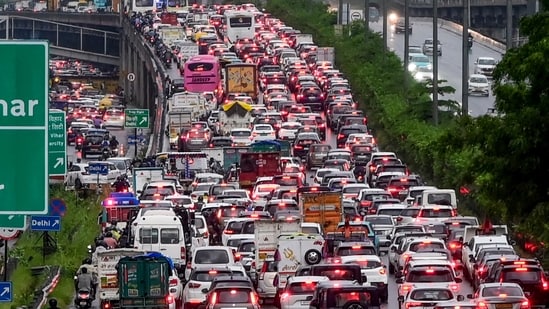
A missing link, dead-end street or large gated block can push traffic onto a busy arterial, where a single breakdown or minor accident can quickly create a gridlock.
This is the paradox of India’s growing cities. Governments widen roads, build flyovers and elevated corridors, yet congestion returns. More road capacity attracts more traffic, while neighbourhood streets remain poorly connected.
But what if cities are building roads in the wrong places?
The problem, urban planners and mobility experts say, is not simply a shortage of roads. It is a shortage of connected roads.
A well-functioning network needs a hierarchy: arterials wider than 35 metres for longer-distance movement; sub-arterials of 20-35 metres connecting neighbourhoods; collector roads of 10-20 metres for local traffic; and streets narrower than 10 metres providing direct access to homes and amenities.
When these layers connect, traffic has multiple routes, buses can avoid congested arterials and access more neighbourhoods directly and quickly, and pedestrians can reach public transit stops without long detours. But much of India’s urban road network does not work this way.
{{/usCountry}}When these layers connect, traffic has multiple routes, buses can avoid congested arterials and access more neighbourhoods directly and quickly, and pedestrians can reach public transit stops without long detours. But much of India’s urban road network does not work this way.
{{/usCountry}}Also read: NHAI identifies 15 key traffic bottlenecks in Pune for priority fix
The missing middle
A WRI India report released on August 11 found that secondary roads—those between 10 and 35 metres wide—are particularly scarce in several major cities.
They account for just 3.7% of total road length in Hyderabad, 6% in Kolkata, 7% in Delhi, 7.4% in Chennai and 9.7% in Pune. Bengaluru has 12.5%, Ahmedabad 16.4%, while Mumbai leads with 35%. In Hyderabad, roads narrower than 10 metres account for 95% of the network. In Chennai, Bengaluru, and Pune, such roads account for more than 85% of the network.
But road length alone does not determine connectivity. Location and configuration matter just as much. “Delhi and Ahmedabad have relatively uniform secondary networks, while Bengaluru and Pune show poorer connectivity in peripheral areas,” says Pawan Mulukutla, executive programme director at WRI India.
In Bengaluru’s Whitefield, travelling between two points three kilometres apart requires a 4.7-kilometre drive, with a 1,700-metre detour. In Basavanagudi, the detour is only about 400 metres, WRI analysis shows.
The contrast reflects planning: Whitefield, despite being a major IT hub, developed without enough connecting streets. However, Basavanagudi, one of the old city neighbourhoods, has an established road network.
When roads go nowhere
Bengaluru’s problem is not just narrow roads; some newer roads are wide, but fail to connect.
Urban expert Ashwin Mahesh cites one such missing link: A 60-foot road near his home in Puttenahalli dead-ends on one side and narrows to 30 feet on the other. Developers may build wide roads that are later handed to the municipality, but if adjoining links are not completed, those roads become bottlenecks rather than solutions.
He also points to the problem in Bannerghatta Road, which narrows from more than 100 feet to less than half its width before reaching a highway, pushing traffic into residential areas.
Bengaluru and Delhi have similar connectivity scores in WRI’s analysis—0.44 and 0.46. Yet Bengaluru has a higher dead-end rate: 0.25 compared with Delhi’s 0.18. Rapid peripheral growth has compounded the problem. High-rises, gated communities, malls and office campuses have transformed the tech corridor, but development has outpaced the supporting street network. The Namma Metro Purple Line has improved regional connectivity, but cannot solve fragmented neighbourhood streets, the report says.
The Karnataka State Finance Commission has asked the government to build at least 250 km of roads annually for four years to address congestion in Bengaluru. The question is whether these investments create new connections or simply add capacity to an already vehicle-heavy system.
The superblock problem
The problem is even more visible on foot.
Mobility expert Shreya Gadepalli says urban blocks ideally should not exceed one hectare. A street every 100 metres, common in older Indian neighbourhoods, creates multiple routes with the fewest detours to a destination. The detour should ideally not be more than 50% of the as-the-crow-flies distance.
Modern planning has moved towards larger “mega-blocks” of roughly one square kilometre, particularly since the 1960s in Delhi and the 1990s elsewhere.
Gated developments can make matters worse. In Gurugram, Gadepalli recalls, a bus stop 250 metres away in a straight line required a 1.7-kilometre walk because there was no direct route.
That matters for public transport. Gadepalli says a 300-metre walk can encourage use, while a 600-metre or longer walk deters use of public transport.
Sarojini Nagar in Delhi, built in the 1950s, illustrates the older approach. Its low-rise street grid and porous access allowed easy movement between buildings. Redevelopment is now replacing parts of that pattern with larger, walled and gated complexes, Gadepalli says.
The result can be a city where a metro station or bus stop is nearby, but effectively inaccessible on foot, compelling people to switch to private vehicles. This is especially problematic for Indian cities already facing a severe mobility crisis and poor air quality.
Land is the hard part
Why not simply build the missing links? The answer is often land.
Acquiring parcels through built-up neighbourhoods is expensive, politically difficult and time-consuming. “The main barrier to connecting roads in cities is difficulty in land acquisition. Cities therefore frequently opt for quick fixes such as wider roads, flyovers and elevated corridors that can be built as standalone projects,” says Madhav Pai, CEO of WRI India.
But Delhi and Ahmedabad show how institutional mechanisms can help.
Delhi’s early master planning involved large-scale land acquisition by the Delhi Development Authority (DDA), making it easier to establish street grids. Under the newly notified master plan, the authority is now working on a comprehensive road grid for new neighbourhoods under its land-pooling policy. Private landowners will be combining land parcels to build properties and cede portions to DDA, which would build the trunk infrastructure.
Ahmedabad’s town-planning scheme similarly facilitates land acquisition for roads and amenities. Combined with mixed land use, this has helped keep average trip lengths relatively short, says Pai. The intensity of travel demand is lower in Ahmedabad than in other Tier-1 cities. It also has multiple modes of public transport, such as buses, BRT, and the Metro, which place relatively less pressure on the road network, adds Mulukutla.
Mumbai has the highest share of secondary roads among the tier-1 cities studied by WRI—35%. The city has systematically augmented its road network while undertaking redevelopment of existing areas, says Pai. Projects such as the Santa Cruz-Chembur and Jogeshwari-Vikhroli link roads have strengthened connections.
Yet, Mumbai’s road density is only 0.46, compared with 0.99 in Delhi and 1.21 in Bengaluru. Its connectivity value is also lower than Delhi’s 0.65 and Bengaluru’s 0.66. For Mumbai, the priority should be to connect fragmented roads and eliminate dead ends, rather than simply adding capacity, says Mulukutla.
Also read: NHAI provides Chakan traffic police a crane, patrolling van
Pune’s work in progress
Cities must address legacy issues before they start new projects.
In Pune, the 700 km of roads proposed in the city’s 1997 development plan remain unfinished. Land acquisition issues, funding constraints, public resistance, and poor planning have left crucial connections incomplete. But Pune’s problem is not confined to the periphery. Many roads in the core areas, which are 24-36 metres wide, and even established ones like Baner-Pashan, have missing links.
Civic body chief Naval Kishore Ram says the administration is now focused on completing all these projects. As many as 33 critical links that impede traffic have been identified, 12 have been prioritised, with funds for land acquisition allocated by the state government. Work has begun on five, and the administration aims to complete the 12 within a year and all 33 in about two years.
With around 65 million sq ft of new construction projected over the next four years, Ram says it is “critical to ensure that there’s no disconnect between development and planning”.
Make existing roads better
Building connections is only part of the answer.
Shashi Verma, chief technology officer at Transport for London, says cities should first examine how existing road space is used—particularly for parking and commercial activity—and whether buses have enough space to ply.
Parked cars and two-wheelers often occupy valuable road and pedestrian space. Experts have called for parking reforms, variable pricing and “road diets” that reallocate space rather than continually adding lanes. But such measures often face weak enforcement and political resistance.
Poorly connected networks also push motorists into residential streets as shortcuts around congested arterials, turning neighbourhood roads into new choke points. Gadepalli points to Barcelona’s approach, where vehicle cut-throughs can be restricted while walking, cycling and public transport connections are maintained.
Also read: Chandigarh: FOSWAC flags concerns over traffic, CHB issues and power bills
Connect the gaps
The solution differs between new and established neighbourhoods.
For greenfield development, land pooling and integrating road construction with urban development can ensure that the street network grows alongside housing and commercial projects.
In built-up areas, acquiring land for missing links is harder. Gadepalli suggests Transferable Development Rights (TDR) to compensate landowners who surrender land for public cut-throughs.
With much of India’s infrastructure for 2047-50 still to be built, cities have a choice: repeat the cycle of widening roads and building flyovers, or invest in the more important task of connecting neighbourhoods. The most useful road may not be the widest one. It may be the short missing link that turns a 30-minute journey into a 10-minute one.