Fishing communities along Kerala, southern Tamil Nadu and the Lakshadweep Islands are on alert after the Indian National Centre for Ocean Information Services (INCOIS) warned that a swell surge, locally known as Kallakkadal, could batter the coast on Thursday.
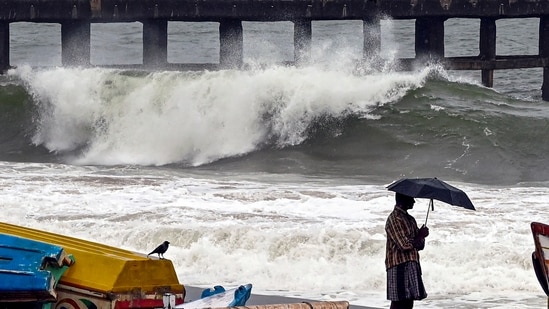
INCOIS, an autonomous body under the Ministry of Earth Sciences that tracks and forecasts ocean conditions during extreme weather, from high swells to storm surges, said high-period swells generated far out in the southern Indian Ocean have already reached Indian shores.
Also Read | Kerala’s mysterious ‘Thief Waves’ return—What tourists and locals need to know
INCOIS's network of moored buoys and wave rider buoys — devices anchored to the seabed that measure surface wave activity — deployed along the southern coast confirmed the swell, feeding data into the multi-model ocean prediction system that INCOIS uses to track sea conditions.
What is a swell surge?
A swell surge forms very differently from the choppy waves whipped up by local winds. It begins as an ordinary wind wave, generated when a storm blows steadily across a vast stretch of open ocean — a distance oceanographers call the "fetch".
{{/usCountry}}A swell surge forms very differently from the choppy waves whipped up by local winds. It begins as an ordinary wind wave, generated when a storm blows steadily across a vast stretch of open ocean — a distance oceanographers call the "fetch".
{{/usCountry}}As these waves move away from the storm that created them, a process called dispersion sorts them into smoother, more uniform sets: the longer, faster waves pull ahead of the shorter ones, which lose energy and fade out along the way.
What survives the journey are long, powerful, evenly spaced waves that can travel thousands of kilometres with barely any loss of energy. Their wavelength depends on how intense and long-lived the parent storm was, along with the size of the ocean basin and how the storm evolves.
In the most severe cases, swells can stretch beyond 700 metres. Because they arrive without the accompanying wind and rough weather that usually signal danger, swells can strike a calm, sunny coastline without warning — catching fishing communities off guard, flooding low-lying settlements, damaging boats and gear, eroding beaches and hurting the livelihoods that depend on the coast.
Research by Suchandra A Bhowmick, Raj Kumar, Sutapa Chaudhuri and Abhijit Sarkar, in their paper 'Swell Propagation over Indian Ocean Region' published in the International Journal of Ocean and Climate Systems in 2011, traced this pattern by simulating 13 years of wave data, from 1993 to 2005.
The study found that swell heights stay low through April, in the range of 0.5–1 metre, before climbing to 1.5–2 metres roughly 7 to 15 days ahead of the monsoon’s arrival over the subcontinent, and reaching 2–3 metres by the monsoon's peak in July. That build-up means swell activity can act as an early signal of the monsoon’s approach.
This seasonal clustering is linked to the Southern Ocean storm belt known as the "roaring forties", roughly 40°S to 50°S, which intensifies through the Southern Hemisphere's winter.
Separate research has found that swells from this belt show increased propagation towards the Bay of Bengal specifically during June–September (Sabique et al., 2012). A later study — by S Sreelakshmi and PK Bhaskaran, published in Climate Dynamics in 2023, used 42 years of wave data and traced swell energy back to its source. They found that this is also the window in which the southwest monsoon’s own wind-driven wave field peaks in the north Indian Ocean, running alongside, though separately from, the extratropical swells arriving from the south.
Also Read | High energy swell waves to be experienced along west, Tamil Nadu coasts
Kerala was last struck by damaging Kallakkadal events in 2024. On March 31 that year, high swell waves, which local authorities had said were in the range of 11 metres, reached the coast and inundated beaches and adjoining areas. The Kerala State Disaster Management Authority had linked this to a low-pressure system formed over the South Atlantic Ocean.
Further surges through April and May prompted what INCOIS and the National Disaster Management Authority described as the first red alert issued for the Kallakkadal phenomenon in south Tamil Nadu. Kerala's disaster management authority separately called its red alert that same week the first issued for the state.
More recently, INCOIS flagged the risk again on August 5-6 earlier this year, when authorities warned of possible sea erosion and rough sea conditions along stretches of the Thiruvananthapuram, Kollam and Alappuzha coasts, roughly two weeks before the current warning.
How India tracks and forecasts them
INCOIS forecasts these conditions through the Indian Ocean Forecasting System (INDOFOS), which projects wave heights, swells, currents, tides and winds up to a week in advance. That lead time gives authorities room to issue warnings and organise evacuations of vulnerable coastal areas before conditions turn dangerous.
A second, more targeted system — the Swell-Surge Inundation Vulnerability Advisory System (SIVAS) — was built specifically to anticipate Kallakkadal flooding along the Kerala coast. According to INCOIS, SIVAS offers a three-day lead time.
The toll on the coast
Because swells can strike a calm sea, tracking their movement matters as much for ships and fishing boats still out at sea as it does for vessels already close to shore.
Also Read | New study links rising sea surface temperatures to humid heatwaves over land
Unless boats are moved to safer anchorage in time, they can be smashed against each other or against the coastline. Nets, fishing gear and landing centres near the water often take the heaviest damage — a pattern documented in reports by organisations including the International Collective in Support of Fishworkers (ICSF).
Much of the responsibility for limiting the damage falls on the communities themselves — moving boats early, heeding advisories, and staying alert to the sea.