
 E-Paper



Himalayan floods: We are designing for a climate that no longer exists
This article is authored by Dikshu C Kukreja, urban planner, socio-environmentalist and managing principal, CP Kukreja Architects, New Delhi.

 Prefer HTon Google


During the recent Nepal-Tibet disaster, the Trishuli River reportedly rose by nearly nine metres in about 30 minutes. At least 19 bridges and roughly 40 kilometres of roads were reported damaged or destroyed in the initial assessment. These figures are not merely a measure of the flood’s force. They expose a planning problem.
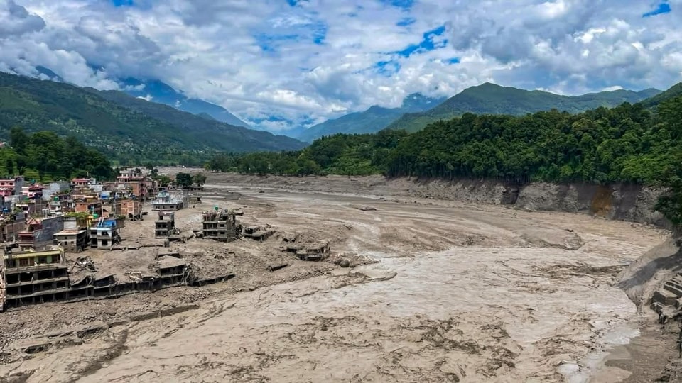
When a river rises nine metres within half an hour, warning time becomes as important as structural strength. When 19 bridges are lost in the same event, we are not looking at 19 separate engineering failures. We are looking at the collapse of a network. Villages lose access to hospitals, rescue teams lose access to communities, and food, fuel and communication are interrupted together.
Investigations indicate that the event began with the collapse of part of a glacier, sending ice and rock into the river system and producing a high-speed debris flow downstream. The distinction matters because a Himalayan flood is rarely water alone. It can carry boulders, sediment, trees and pieces of buildings, while changing the river channel as it moves.
Designing only for a conventional volume of water is therefore designing for the wrong event.
The wider climatic context is equally difficult to ignore. ICIMOD’s 2023 assessment found that glacier loss across the Hindu Kush Himalaya was 65% faster between 2011 and 2020 than during the previous decade. The glacier- and snow-fed river basins of this region support around 1.9 billion people across Asia. What changes in the high mountains does not remain in the high mountains.
Yet much of our infrastructure continues to be planned using historical rainfall, discharge and slope records as though the baseline were stationary. A bridge expected to last 50 years may be designed using a river history that no longer represents the next 50. The useful life of infrastructure extends into a future climate, but its design assumptions are often drawn from a past climate.
This is not an argument for discarding historical data. It is an argument for placing it alongside projected rainfall intensity, glacial change, sediment loads and slope instability.
Design values in the Himalayas should not be frozen at the time of approval. They need periodic review as the science changes, particularly for critical roads, bridges, hospitals, power systems and evacuation routes.
India has a particular reason to confront this gap. According to NITI Aayog, the Indian Himalayan Region stretches for about 2,500 kilometres across 13 States and Union Territories and is home to nearly 50 million people. It cannot be managed as a narrow environmental category. It is a vast inhabited region with strategic roads, growing towns, tourism economies, hydropower assets and essential ecological systems occupying the same terrain.
Our planning machinery, however, continues to divide that terrain by sector. A road is assessed as transport. A dam is assessed as energy. A hotel is assessed as tourism. A settlement is assessed through land use. Each project may satisfy its own conditions while the combined pressure on the watershed remains unmeasured.
That is the central weakness. The mountain experiences cumulative change, while the approval system examines individual files.
Consider a valley in which a road is widened, several hotels are constructed and a hydropower project is added. The road cutting alters the slope. Excavated material narrows a drainage path. The hotels increase paved surfaces and seasonal population. The power project introduces more access roads and river-edge infrastructure. None of these interventions alone may appear decisive. Together, they change how water moves, where debris collects and how many people require evacuation.
We, therefore, need a catchment-level risk account before further construction is approved. It should record slope cutting, muck disposal, loss of vegetation, alteration of drainage, construction within flood and debris corridors, and the dependence of communities on single access routes. Without such an account, the cumulative impact of development becomes visible only when the catchment fails.
We must also stop representing a Himalayan river as a thin blue line between two fixed banks. During an extreme event, the river occupies a much larger space that may include old channels, seasonal streams and alluvial fans. Land that has remained dry for 20 years may still belong to the river during the 21st. Protecting that space is not anti-development. A flood corridor is infrastructure, just as surely as an embankment or bridge.
The same precision is required in tourism planning. Carrying capacity is usually expressed through beds, parking spaces or daily footfall. In a mountain town, it should also include evacuation time, emergency shelter, water availability and the number of independent access routes. If ten thousand visitors depend on one vulnerable road, the destination’s real capacity is determined by that road, not by the number of hotel rooms.
Technology has improved our ability to monitor glaciers, rainfall, rivers and slopes. But a sensor is not an early-warning system by itself. The relevant measure is how many minutes of actionable warning reach the last exposed settlement, in a language people understand, through a communication system that continues to work when electricity and mobile networks fail. In a transboundary mountain region, upstream data-sharing is also a form of downstream infrastructure.
Some decisions will be uncomfortable. Certain sites should not be built upon. Some roads will require alternatives rather than repeated widening. Some tourism corridors will need weather-linked restrictions. Some projects that appear viable in isolation may prove unacceptable when the full catchment is considered.
This does not mean choosing ecology over development. It means recognising that development which repeatedly destroys its own roads, isolates its own settlements and rebuilds the same exposure is not development at all. The Nepal flood has shown us the speed at which the mountain can change. Our planning institutions now have to show that they can change before the next river rises.
(The views expressed are personal)
This article is authored by Dikshu C Kukreja, urban planner, socio-environmentalist and managing principal, CP Kukreja Architects, New Delhi.


