The IMD has issued a 'red alert' for south Konkan, Goa and south central Maharashtra and orange alert for north central Maharashtra, east Vidarbha and west Vidarbha for the next two days. The red alert for Pune, Satara and Kolhapur districts indicate heavy to extremely heavy rainfall in western Maharashtra over the next three days. The red alert is valid from July 6 to 8 for the Satara district and from July 7 to 9 for the Kolhapur district.
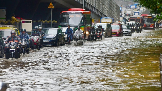
The alert came as the Panchganga river level in Kolhapur was just seven feet short of the warning mark as of Wednesday night. Of 17 teams of the National Disaster Response Force (NDRF) deployed in areas of Maharashtra that have reported heavy to very heavy rainfall, two teams have been stationed in flood-prone Shirol tehsil and Kolhapur city. The district administration in Kolhapur has taken preemptive measures to tackle any flood situation in the district, which was battered by floods in 2019 and 2021.
"During this period, the respective regions will witness extremely heavy rainfall at isolated places in ghat areas. For Pune, a red alert has been issued for July 7 and July 8," PTI quoted IMD officials as saying.
Delayed, then downgraded: Heavy showers not likely, Met demotes alert to yellow
{{/usCountry}}Delayed, then downgraded: Heavy showers not likely, Met demotes alert to yellow
{{/usCountry}}The southern state of Telangana is also likely to receive heavy to very heavy rainfall in the next few days, according to Met department.
"In the last 24 hours, Telangana has received good rainfall; while Nagarkunool recieved rainfall of 16 centimetres (cms), some of the districts have received 9cms of rainfall. The temperature in the state also went from 30 to 32 degrees Celcius in the past 24 hours," scientist of Metrological Center Hyderabad Sravani said, as quoted by ANI.
"Telagana state will receive a good amount of rainfall in upcoming days, the districts in the southern part of the state-- Jogulamba Gadwal, Vanaparti, Nagarkurnool, and Nalgonda are expected to receive heavy to very heavy rainfall, while the central parts can also experience good rainfall in the next five days with heavy to very heavy rainfall in Southern parts of Telangana tomorrow and day after tomorrow (i.e., on Wednesday and Thursday)," she added.
The IMD has also predicted heavy to very heavy rainfall in South Interior Karnataka, Vidarbha, and Chhattisgarh.
"Heavy to very heavy rainfall in...Telangana and South Interior Karnataka on 06th and 07th; Vidarbha on 08th; Chhattisgarh on 07th and 08th July, 2022," it said in a series of tweets.
"Scattered heavy to very heavy rainfall with isolated extremely heavy rainfall also likely over Konkan and Goa during next 5 days and isolated extremely heavy rainfall likely over Coastal Karnataka on 06th," it added.
Himachal rain: Girl dies in landslide in Shimla, four missing in Kullu
Delhi is likely to witness light rain and thundershower on Thursday even as the city's maximum temperature settled at 38.6 degrees Celsius the previous day.
"There will be a generally cloudy sky with the possibility of light rain and thundershowers at isolated places. The city's maximum and minimum temperatures will hover around 36 degrees Celsius and 28 degrees Celsius respectively," PTI quoted an IMD official as saying.
(With inputs from agencies)