
 E-Paper



The lingering impact of a ‘super’ El Niño: Largest heat effect may still lie ahead
Effects of a weak monsoon could continue beyond Sept. Next concern: at 1.55°C of global warming, a powerful El Niño could make 2027 a record-breaking heat year

 Prefer HTon Google


Anyone who watched Argentina’s football World Cup matches (before the final with Spain) will understand India’s monsoon this year. For long stretches, Argentina’s goals would not come. Then came a rush of late goals that changed the scoreline. The monsoon has followed a similar pattern.
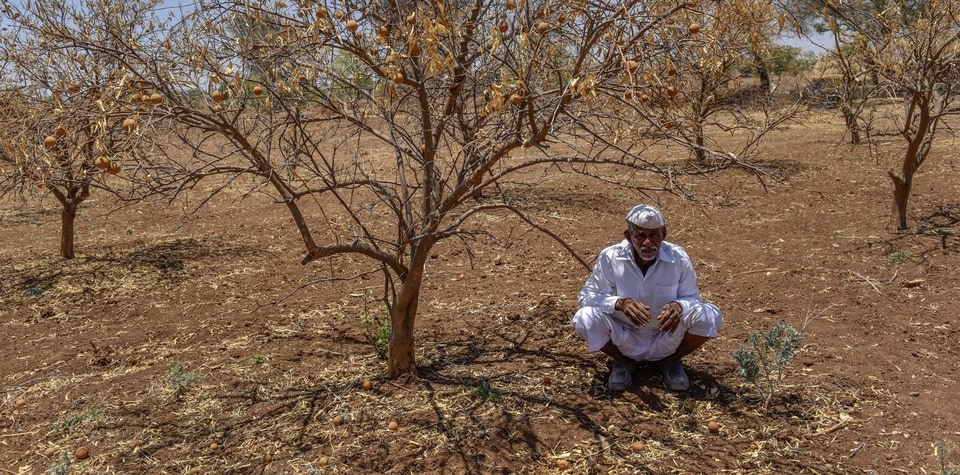
June ended with rainfall about 40% below normal, making it India’s fifth-driest June since record-keeping began in 1901. Rain returned in heavy bursts in early July, with places like Mahabaleshwar and Lonavala recording close to 1,000 mm in just 48 hours. In an extraordinary event on July 23, Umergam in Gujarat’s Valsad district received 1,064 mm of rain in 24 hours, the third-highest daily rainfall ever recorded in India. The national deficit narrowed to 15% by July 26.
This is a monsoon of contrasts.
Several weeks of weak rain can be followed by a few days of intense downpours. Areas waiting for rain can suddenly face floods and crop damage, while other regions remain dry. Heavy rain can change the national rainfall average, but cannot quickly restore soil moisture or groundwater storage lost during weeks of weak rain.
The impact is visible in agriculture. By July 17, kharif sowing had covered about 658 lakh hectares, around 42 lakh hectares, or 6%, less than at the same time last year. Pulses, coarse cereals, oilseeds, and cotton were about 15%, 11%, 6%, and 6% behind last year, respectively. Rain can allow delayed sowing to resume, but another break can damage young plants. Heavy rain returning later can cause waterlogging. For farmers, the distribution of rain matters as much as the seasonal total.
A warmer climate is sharpening these contrasts. For every degree Celsius of warming, the atmosphere can hold about 7% more water vapour. This does not mean rain increases evenly. When a suitable weather system forms, more moisture can be released within a short period. Warming raises the potential for heavier downpours, while monsoon winds determine where and when they occur.
The rapidly strengthening El Niño is adding to the concern. El Niño develops when the tropical Pacific becomes unusually warm, altering winds and rainfall across the tropics. For India, it generally weakens the monsoon circulation and raises the likelihood of below-normal seasonal rainfall. However, it does not stop extreme rain. A weak monsoon can still contain short bursts of very heavy rainfall, particularly when the seas around India are warm.
This El Niño is developing unusually early and rapidly. The strongest event observed so far, in 2015-16, peaked near 2.75°C. The latest forecasts indicate that the current El Niño could peak near 3.5°C. If that happens, it would surpass every El Niño in the observational record. We do not have a formal category such as “Super El Niño” in scientific circles, but that is what this event is shaping up to be. As global warming accelerates and climate extremes continue to break records, we may soon find ourselves scrambling for new names to describe these monster events.
El Niño forecasts are also better than before. Satellites, ocean buoys and climate models now track surface warming and the heat below the Pacific, giving us several months of warning. These advances provide time for informed planning and preparation.
El Niño is part of a natural cycle, but it is developing in an ocean already carrying record amounts of heat from human-caused warming. The ocean has absorbed more than 90% of the excess heat trapped in the climate system. At the rate recorded in 2025, the ocean is absorbing heat equivalent to the energy of about 12 Hiroshima atomic bombs every second.
The effects of a weak and uneven monsoon could continue beyond September. Poor rainfall distribution can reduce soil moisture, reservoir storage and groundwater recharge. This can affect the rabi crop season, drinking-water supplies, hydropower and electricity demand. India may enter the next hot season with stressed water resources even if occasional heavy rain creates an impression of recovery.
The next concern is heat. El Niño usually reaches its strongest phase towards the end of the year, while its largest influence on global temperature often appears after several months. While 2024 remains the warmest year on record, at about 1.55°C of global warming, a powerful El Niño could make 2027 the next record-breaking year.
For India, this could mean some of the hottest months and seasons yet experienced, with severe heatwaves, warmer nights, crop stress and rising demand for water and electricity. The country could face the next pre-monsoon heat season while still carrying the effects of a weak monsoon.
Preparation for 2027 cannot begin next summer. Farmers need timely advice on sowing, short-duration crops and irrigation. Reservoirs must be managed for scarcity while retaining room for sudden heavy rain. Health systems should update heat-action plans, and power utilities should prepare for higher cooling demand.
Last-minute goals can change the score and win a football match. But a few days of intense rain cannot undo weeks of agricultural and water stress. Such rain may even bring floods. A super El Niño is developing, and its largest heat impact may still lie ahead. Preparations across agriculture, water, health, power and disaster management should begin now.
--
Roxy Mathew Koll is a climate scientist at the Indian Institute of Tropical Meteorology and a lead author and reviewer of recent IPCC reports. The views expressed are personal. He is on X as @RockSea, and Instagram as @roxy.koll.)


