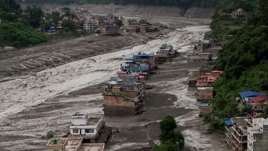
A day after the deadly Nepal flash floods, scientists and disaster-response agencies continued to work out what had caused the wall of water, mud and debris that tore through the Himalayan river valleys along the China-Nepal border on August 26. The working hypothesis remains an ice-rock avalanche — a large chunk of a glacier breaking away and cascading down — but what set that avalanche off is still under examination.
The single sharpest development on Thursday came from the US Geological Survey (USGS), which revised its initial reading of the event. What it had first logged as a magnitude 4.4 earthquake — briefly assumed to be the trigger — was reclassified as a magnitude 5.2 landslide. “Additional analysis of nearby seismic stations, long period seismic waves, and satellite imagery led to the determination that the seismic event was instead a glacial collapse and debris flow, and that no earthquake had occurred,” the USGS said. In other words, the tremor that officials in Kathmandu had first suspected of triggering the flood was the collapse itself.
A second, related hazard emerged the same evening as Nepal and China warned of two lakes that have developed on either side of their border and threaten to burst in a region still grappling with the catastrophic flood. Nepal’s National Disaster Risk Reduction and Management Authority warned that a lake had formed upstream on the Lhende Khola after the debris flow blocked the river’s course. “A lake covering an area of approximately 0.11 square kilometres has formed due to the obstruction of the Lhende Khola’s flow in the upstream area, about 18 kilometres above the Rasuwagadhi border point,” the authority said on X. “Given the risk of a potential major flood, all individuals in the downstream areas are urged to exercise necessary vigilance and remain on high alert.” The concern is a familiar one in the region: an ice-and-debris dam of this kind is inherently unstable, and its sudden failure can send a second surge through the same valley that has just been devastated.
Deep Dive
What caused the recent flash floods near the Nepal-China border?
Why are new lakes forming near Nepal that threaten to overflow?
How does climate change contribute to glacier collapses and related disasters in the Himalayas?
Also Read | Grim aerial footage captures Nepal floods’ trail of destruction, 800 still missing
{{/usCountry}}Also Read | Grim aerial footage captures Nepal floods’ trail of destruction, 800 still missing
{{/usCountry}}Separately, China warned that 3 million cubic meters of water — the equivalent of about 1,200 Olympic swimming pools — are expected to flow into an already dammed lake on its side of the border over the next three days, creating a high risk of a breach, with peak flow expected around September 1. “The volume of water is continuing to increase, and so is the risk,” Zhu Jinfeng, a researcher at the water resources ministry’s hydrology department, told state broadcaster CCTV.
Experts have long flagged this pattern of vulnerability across the Hindu Kush Himalaya (HKH). An assessment published in May by the International Centre for Integrated Mountain Development (ICIMOD) found that four of the eight countries in the HKH region — India, Nepal, Bangladesh and Pakistan — each recorded more than 10 major disasters in 2025, ranging from landslides and floods to glacial lake outburst floods (GLOFs). In June, ICIMOD’s monsoon outlook cautioned that a below-normal monsoon forecast for parts of the HKH in 2026 would not translate into lower disaster risk; short bursts of intense rainfall, rising temperatures and growing water stress could, it warned, make the season more dangerous rather than less.
The underlying science has also been sharpening. In a peer-reviewed study published only weeks before the disaster in the journal Global and Planetary Change, a team led by Gunjan Silwal of Newcastle University — including a co-author from ICIMOD — mapped glacier change in the Langtang catchment, the Nepali basin immediately south of where the August 26 collapse originated. It found that glacierised areas above 4,000 metres in the catchment had been warming at 0.31°C per decade — roughly five times the global average — and that the region had lost more than 40% of the ice cover mapped at the end of the Little Ice Age. Most significantly for events of the kind now under investigation, the paper identified fragmentation and disconnection of high-elevation ice — the same process suspected in the Rasuwa collapse — as the emerging dominant mode of glacier retreat in the region, with what its authors described as implications for “associated geohazards.”
Also Read | What caused Nepal’s deadly floods? US monitor points to ‘glacier collapse’, not quake
The same corridor has now flooded twice in 14 months. In July 2025, a flash flood attributed to a GLOF struck the Lhende Khola — the same tributary that has now been obstructed a second time. “The Lhende Khola has flooded twice in fourteen months, this time most probably triggered by an ice avalanche blocking the river and releasing a sudden surge downstream. This still needs to be confirmed, as we receive further information. These are cascading hazards: a cryosphere event becomes a flood in a settlement within hours,” said Saswata Sanyal, disaster risk reduction specialist at ICIMOD in Nepal.
Some Indian regions have had similar incidents. On August 13, at least seven workers were killed at an under-construction hydropower tunnel in Chamoli, more than 24 hours after a suspected aquifer burst sent a surge of water and debris through the Vishnugad-Pipalkoti project site. In February 2021, the same district was hit by a massive rock-and-ice avalanche that triggered a flash flood down the Rishi Ganga and Dhauliganga rivers, killing more than 200 people and damaging two hydropower projects.
Himanshu Thakkar, coordinator of the South Asia Network on Dams, Rivers and People (SANDRP), said the sites of these disasters kept recurring but their lessons were not being drawn. “We are not revisiting our disasters. We need learnings to come out and more importantly, independent committees to do a full audit into these incidents,” he said.
Also Read | Indo-Nepal border: Six washed down bodies from Nepal recovered from Gandak
Neera Shrestha Pradhan, water and disaster-risk-reduction lead at ICIMOD, said the immediate need was for community-based early warning systems that could operate across borders. “In this case, a cross-border early warning system could be a strong example of cooperation between the two countries. Our experience shows that providing information alone is not enough. Communities also need to be aware about how to translate this information and prepare themselves to act on it without panicking. This event is a hard reminder that in areas where such disasters are more likely, communities need to stay alert and stay prepared for the unforeseen,” she said.