E-Paper



Highest rainfall recorded on a June day in Delhi in 88 years
Delhi received record-breaking rain, highest in June since 1936, leading to a drop in temperatures. IMD issues alerts for heavy rain over the weekend. Monsoon has picked up pace across the country.

 Prefer HTon Google


Hours after the Capital received the most rain it has in a single June day in almost 90 years — tumbling multiple records and bringing the city to a grinding halt —the India Meteorological Department (IMD) announced that the southwest monsoon had arrived in the Union territory. It usually arrives in Delhi around June 27 and was delayed only by one day this year.
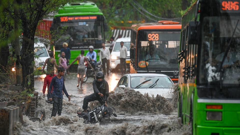
On Friday, Delhi received 23cm of rain till 8.30am, the highest in a day since 1936. IMD defines “heavy” rainfall as 6.45cm to 11.5cm and “very heavy” rainfall as 11.6cm to 20.4 cm. On Friday, Safdarjung, representative of Delhi’s weather, received nearly 15cm of rainfall in three hours between 4am and 7am.
To be sure, IMD had only predicted “light to moderate” rain across the city for Friday. The Met department has now issued an “orange alert” for the next two days, forecasting “moderate to heavy rain” in the city on Saturday. It has forecast “heavy to very heavy” rainfall on Sunday.
Delhi’s maximum on Friday was 32.5°C, which was five degrees below normal. It was 35.4°C a day earlier. The minimum was 24.7°C, three degrees below normal. It was 28.6°C a day earlier. Forecasts show Delhi’s maximum should drop further over the weekend and will likely go below 30°C. The minimum should hover around 23-25°C.
The last time June had a higher single-day spell of rain was on June 28, 1936, when 23.55cm was recorded. IMD also said with Friday’s spell, June has now recorded 23.45cm of monthly rainfall, which is over three times the normal monthly average of 7.41cm. This is again Delhi’s highest monthly total for June after 1936 when 41.58cm was recorded.
Monsoon gathers pace
The monsoon was sluggish since June 11 and picked up only this week, gathering momentum and sweeping across the country. The main reason for the heavy rains is a low-pressure area hovering over the northwest Bay of Bengal, off north Odisha, weather officials said. “Whenever a low-pressure area forms over head of the Bay of Bengal, it moves with the monsoon trough and activates monsoon rainfall. This low-pressure area will bring heavy rainfall over east and central India first and then over NW India. The monsoon will be very active now. In Delhi, most of the extremely heavy rain occurred in a couple of hours. This is unusual,” said M Mohapatra, director general, IMD.
A cyclonic circulation is also lying over northeast Rajasthan and neighbourhood in lower tropospheric levels. A trough is running from the cyclonic circulation over northeast Rajasthan to the low-pressure area over northwest Bay of Bengal in lower tropospheric levels.
Under their influence, fairly widespread to widespread light to moderate rainfall accompanied by thunderstorms, and lightning is very likely over Uttarakhand, Himachal Pradesh, Haryana-Chandigarh-Delhi, East Rajasthan, Madhya Pradesh, East India; and widespread light to moderate rainfall over Jammu-Kashmir-Ladakh-Gilgit-BaltistanMuzaffarabad, Punjab, and Uttar Pradesh over the next five days.
Monsoon rainfall is active over almost the entire country according to IMD’s satellite imagery. “After its revival, monsoon will progress further and cover the whole country by 5 July. Active monsoon phase expected in the next two to three weeks with heavy rains along west coast and north India. High probability of extreme rains and flooding in north India. We should be alert..” M Rajeevan, former secretary, ministry of earth sciences wrote on X on June 26, based on models which indicated a strong monsoon surge over north India.
The southwest monsoon has also further advanced into some more parts of West Rajasthan, remaining parts of East Rajasthan, some parts of Haryana, some more parts of West Uttar Pradesh, remaining parts of Madhya Pradesh, Chhattisgarh, West Bengal, Jharkhand, Bihar and some more parts of East Uttar Pradesh, IMD added.
Conditions are likely to become favourable for further advance of the southwest monsoon into some more parts of West Rajasthan, remaining parts of Haryana, Chandigarh and remaining parts of Punjab, Uttarakhand, Himachal Pradesh and Jammu during next two to three days, IMD said, warning of heavy to very heavy rainfall over northwest India over the next four to five days. It also warned of heavy to very heavy rainfall over central and east India over the next two to four days and over northeast India over the next five days.
Till Friday, June rainfall was 14% deficient with 35% deficiency over northwest India; 19% over east and northeast India; 19% over central India; 15% excess over south peninsular India.
A sharp departure from dry spell
Other manual weather stations in Delhi – Palam, Lodhi Road, Ridge and Ayanagar — recorded heavy rainfall. In the 24 hours till 8.30 am, Lodhi Road recorded 19.28cm, Ridge 15.04cm, Palam 10.66cm and Ayanagar 6.63cm, IMD data showed. The rain also improved the Capital’s air quality. The 24-hour average air quality index (AQI) recorded a reading of 64 (satisfactory) at 4pm on Friday. It was 79 (satisfactory) a day earlier.
This was Delhi’s lowest AQI reading since it was 45 (good) on September 10 last year.
This extreme spell of rain turns things around for what has been a dry year for Delhi. Between January 1 and June 27, Safdarjung has only received 5.11cm of rainfall, with the highest 24-hour day spell of rain this year being 2.65cm, which was recorded on February 1.
HT on June 8 reported that this was Delhi’s driest start to the year since 2018, with only 4.47cm of rain recorded at Safdarjung in the first five months of this year. This is only 42% of the long-period average of 10.48cm, which Delhi’s base observatory receives in the first five months of the year. The last time Delhi received less rainfall at the start of the year was 4.35cm in 2018. Before Friday, June’s monthly total stood at just 0.64cm.