PUNE An avid Geography-subject lover, Abhishek Rathod has chosen a path very few entrepreneurs dare to take – of doing business with the government.
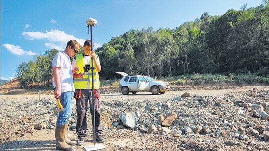
Iowaaska Technologies is a deep-tech, product-based, startup building a robust Geographic Mapping Intelligence platform named “Intelligent Map”, with cloud-based and near real-time technologies.
In the beginning
Abhishek Rathod is originally from Gujarat, but his family settled in Pune. Rathod did his schooling from MIT Gurukul and later went to study BA Geography from the Sir Parshurambhau (SP) College. Having a geographer’s background, Rathod also enrolled for an MSc in GeoInformatics course in Symbiosis College.
Says Rathod, “I was very bad in Science, so I shifted to Geography in Arts. Later I shifted to Science again as there were not many avenues in Geography. Since I loved Geography and always wanted to work or do business which involved that subject. So, the combination of Science and Geography led me to explore the Geographic Information System (GIS) Mapping and Geospatial industry.”
“My dad is a government consultant for ILS Law college for hardware and software infrastructure. He also wanted me to go into business. Coming from a business family background and being brought up in that environment from childhood, helped me to start my own ventures at a very early stage. I did get many opportunities to work abroad, but I want to work for our country and hence, I decided to stay back. So far, I have nine years’ experience of working with international companies and government institutes.”
Early business lessons
{{/usCountry}}Early business lessons
{{/usCountry}}Rathod says, “From childhood we are seeing Google Earth which was first developed by the US Navy and later, it was commercialised and available for common citizens. I wanted to create something similar for our country. During the Covid crisis and the challenges at international borders, the Indian government banned several Chinese applications. What if in the future other countries take some detrimental actions due to which their apps need to be banned? The entire Indian business ecosystem will collapse, but if we have indigenous technology-based applications then we can sustain the ecosystem. So our vision is to create a Geographical Information System (GIS) eco-system for analytics and effectively transform the decision making process. We are on a mission to empower global employment with GIS-driven technology while consulting national and international communities with better environment and self-sustainable living.”
“I started my first company Arianrhod GeoSpatial Solutions. It failed as I was driving that company with the service sector. I suffered huge losses while doing surveys for the national highways, coal mining, etc. After learning my business lessons for three years, my advisors suggested I close down the company. After my service-based business model failed, I started to work on the product-based model and Iowaaska Technologies was formed in 2018,” says Rathod.
Understanding importance of product
On his team building experience, Rathod says “Currently, we have about 10 members in our team including Rinkal Pramani, Akshay Morab, Shaik Najeebuddin , Abhimitra Birru and Ajay Morab. We have engaged interns too. We are working on the B2G2B model and hence, it is very important to generate revenues as we deal with the government sector. We are focussing on advisors and consultants rather than hiring salaried employees. Our advisors are Dr Suyog Lohakare, Jasraj Kalaskar and Rishab Malhotra.”
Explaining the importance of product-based startup, Rathod says, “Our first project was providing consultancy to government agencies and it was during this first project we understood the importance of the product. So, we are developing a product for smart cities and smart villages. We are developing an operating system through which we can transform the ways communities operate.”
“GIS is all about temporal data. Temporal data means data with time of past, present and future. If we have the data of past and present then we can give better prediction of future events. For example, we get traffic data on Google Maps. ‘Live’ traffic data is derived from past data and present road conditions, and future predictions are made by combining these two. We want to create temporal data for India which the government agencies can use it for analytics and decision-making processes. The government can balance its resources according to the demand-supply from the citizen’s side. Some applications for example would be road condition mapping, vaccination progress monitoring, development of educational and healthcare facilities,” he explains.
Incubated at Bhau Institute, COEP
The Bhau Institute at College of Engineering Pune (COEP) in 2019 had invited applications for startups working in the deep-tech sector. Rathod applied and got selected. Vijay Talele is Rathod’s team mentor and helps them keep on one page and in sync with the market reality.
Iowaaska also got selected in the top five startups representing India in Munich, Germany, in 2019 at an event conducted by the German Indian Business Forum.
Product and revenue model
Says Rathod,” Our product is the ‘Intelligent Map (I-Map) which is in the development stage. It will host, monitor evaluate the Geo-Informatics Science (GIS) data for various decision-making processes. We will be certifying the product with basic ISO/ICE standards, Make in India and Atma Nirbhar Bharat. We are looking for investment of USD 1 million against equity for further product development stages.”
“Revenue generation is based on subscription-based Software as a Service model with Intelligent Map as the product. Monitoring and evaluation of the entire administration and operation of the community in these private and government smart cities will be done with the help of our services. The evaluation monitoring data generated of the smart cities will be beneficial for corporates and CSR activities to understand how the city is transforming. Suppose we have a problem related to pollution, government schemes or health issues, the intelligent map will help solve the issue fast. Data needs to be collected for this. This data will be the satellite imagery, drone and field survey data and statistical data. Based on this data and an algorithm, we will be able to analyse and predict future events,” Rathod explains.
Mentor speak
“Iowaaska is focussing on providing services for smart villages and smart cities projects using GIS technology. It will be useful and has huge potential looking at the way villages and cities have started utilising such data to control and manage their areas better and provide services to the citizens. It also can be used by industries which are looking for geographically mapped roads, underground-utility-service pipelines, to aid their decision-making process. They are working with the Zilla Parishad and working to develop the product for five villages. Bhau Institute is also helping team Iowaaska to raise funds.”
-Vijay Talele, CEO, Bhau Institute, COEP