
 E-Paper



Number Theory: Has spring arrived early this year?
.
Updated on: Feb 18, 2025, 08:26:41 IST

 Prefer HTon Google
Share via


Copy link

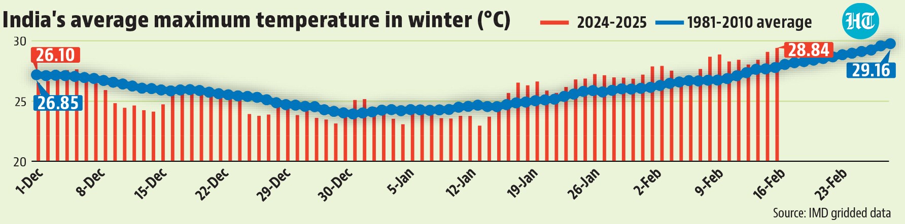
Anecdotally, this appears to be a warmer than usual winter for large parts of India. Is that really the case? An HT analysis of the gridded data of the India Meteorological Department (IMD) – it gives data for maximum and minimum temperatures separately – shows that the feeling of warmth this winter is more due to minimum temperatures than maximum temperatures. However, even maximum temperatures have turned warmer than usual from the third week of January, with the past week averaging closer to what is usual for the week ending February 24. This might be the reason why the weather right now feels almost like spring.

Has spring arrived early this year?
- Overall, the winter season is unusually warm by minimum temperaturesOfficially, India’s winter season runs from December to February, the three months where temperatures are usually the lowest. For the season as whole (up to February 16), only minimum temperatures are unusually warm. India’s average minimum temperature for the season so far is 11.67°C, 0.58°C warmer than the 1981-2010 average, which is considered the normal for temperature. This average minimum is also the 10th warmest since 1951, the earliest year for which IMD has published gridded data. On the other hand, India’s average maximum this winter is 25.36°C, 0.10°C cooler than normal and only 43rd warmest since 1951.
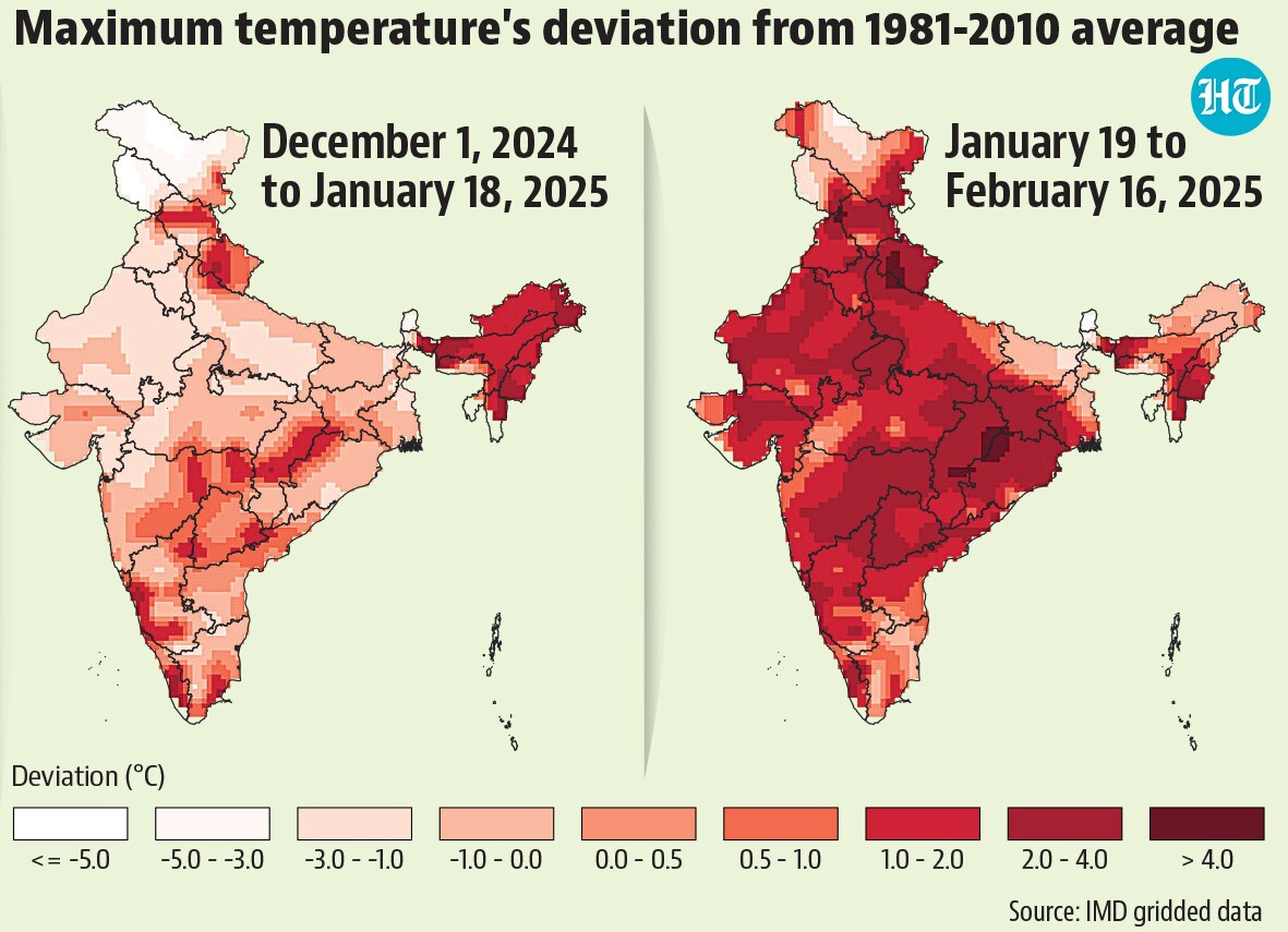
 Maximum temperatures started cool, but are almost spring-like right nowAs the overall trend suggests, minimum temperatures have remained warmer than normal for most of the season even on a daily basis. However, maximum temperatures have undergone a shift. From December 1 to January 18, maximum temperatures were cooler than normal on most days. From January 19, though, maximum temperatures have been largely warmer than normal. This is why the season overall is close to normal although it has been warmer than normal for almost a month. The recent warmth in maximum temperatures is also why the weather feels spring-like right now. The average maximum for the week ending February 16 was 28.12°C. On the normal chart, the 28°C mark is reached is breached only in the week ending February 24, eight days from now and closer to the end of the official winter season. To be sure, in some areas, the spring-like feeling might be even more obvious. For example, Delhi’s maximum temperature (IMD’s gridded data covers an area somewhat bigger than Delhi’s political boundaries) averaged 26.09°C in the week ending February 16. On the normal chart, Delhi is expected to cross the 26°C mark only in the week ending March 1.
- Almost all of India has experienced unusually warm maximum temperatures in the past monthThe shift in maximum temperatures seen from January 19 can be seen almost all over India although the degree of warming is not the same . For example, large parts of Jammu and Kashmir and Ladakh were cooler than normal even in the period after January 18. However, the degree of cooling compared to normal has decreased in even these regions compared to the period before January 18. There are also some exceptions to the general trend. For example, most north-eastern states were warmer than normal in the period before January 18 and have turned cooler than normal after. On the other hand, large parts of Bihar, West Bengal, and Tamil Nadu have remained cooler than normal in both the periods.
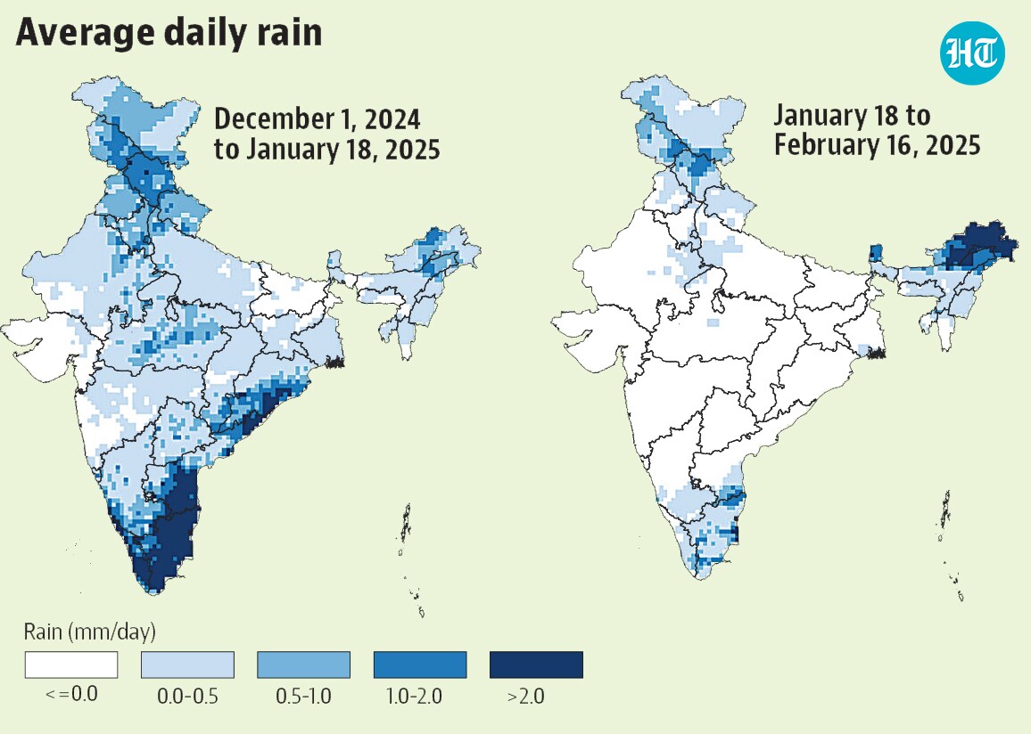
- Completely dry weather since mid-January is behind the unusual warmthAs the accompanying map shows, most of India received rain in the winter season up to January 18. After January 18, the weather dried up in places where maximum temperatures warmed up. This is the broad reason behind the trend in maximum temperatures. However, other factors have also been at play. Usually, cool winds blowing from the hilly regions in the north bring down temperatures for northern plains even if they are not themselves receiving rain. As HT explained on December 16, cool and fast winds blowing from north-western India were also responsible were keeping northern India cool in the second week of December. However, with the season becoming drier even in the hill states, the plains have had a hard time remaining cool.


Unlock a world of Benefits with HT! From insightful newsletters to real-time news alerts and a personalized news feed – it's all here, just a click away! -Login Now!


