Super Cyclone Amphan will start making landfall at 4pm near Sunderbans in West Bengal. It will cross the West Bengal-Bangladesh coast between Digha in West Bengal and Hatiya Island in Bangladesh.
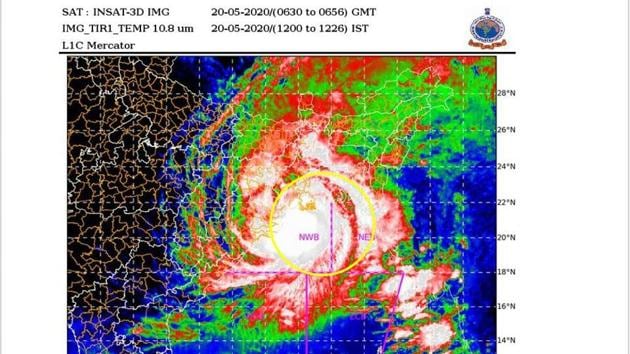
“We can only say now that the landfall process is likely to start around 4pm,” said Sunita Devi, scientist in charge of cyclones at IMD adding that Amphan continues to be an extremely severe cyclonic storm with an intensity of 160-170kmph gusting to 190kmph.
As of 1pm, the super cyclone was 150km east-northeast of Paradip; 95km south-southeast of Digha’ 90km nearly south of Sagar island and 260km west-southwest of Khepupara in Bangladesh.
Watch | Super cyclone Amphan to hit West Bengal today, landfall likely near Sunderbans
During landfall near Sagar Island, the intensity of cyclone is likely to be 155 to 165kmph gusting to 185kmph.
The storm surge is expected to inundate low lying areas of South and North 24 Parganas and parts of East Medinipur district during landfall. Wind speed in Kolkata, Hooghly and Howrah is likely to range between 110kmph to 120kmph gusting to 130kmph which may cause extensive damage in urban areas also.
Gale wind of 75 to 85kmph gusting to 95kmph is also likely to impact the north Odisha coast including Jagatsignghpur, Bhadrak, Balasore, Kendrapara and others.
The cyclone is expected to cause heavy to extremely heavy rainfall over Gangetic West Bengal and heavy to very heavy rainfall over north coastal Odisha on May 19 and 20. It will also cause heavy to very falls over Sub Himalayan West Bengal and Sikkim on May 20 and 21 and Assam and Meghalaya on May 21.
IMD is expecting extensive damage to all types of kutcha houses, some damage to old badly managed pucca structures; potential threat from flying objects; uprooting of communication and power poles, disruption of rail/road link at several places, extensive damage to standing crops, plantations, orchards, falling of palm and coconut trees, uprooting of large bushy trees, large boats and ships may get torn from their moorings.
{{/usCountry}}IMD is expecting extensive damage to all types of kutcha houses, some damage to old badly managed pucca structures; potential threat from flying objects; uprooting of communication and power poles, disruption of rail/road link at several places, extensive damage to standing crops, plantations, orchards, falling of palm and coconut trees, uprooting of large bushy trees, large boats and ships may get torn from their moorings.
{{/usCountry}}NDRF director general, SN Pradhan said on Tuesday all precautionary measures are being taken and people from low lying areas are already being evacuated.
“The biggest challenge is that we are facing two disasters together—covid 19 and cyclone. This is a cyclone in the time of Covid. We are also creating awareness about Covid-19 while creating awareness about Amphan and evacuating people. If a cyclone shelter has a capacity of 1000, because of social distancing and need to maintain sanitary facilities, only 500 to 400 people can be sheltered there,” said Pradhan.