NEW DELHI: Severe cyclone Asani has changed its track significantly and is likely to touch the Andhra Pradesh coast between Kakinada and Visakhapatnam, India Meteorological Department (IMD) said on Tuesday and issued a “red” warning for the Andhra Pradesh coast, which implies that local authorities need to take action to prevent disasters associated with the cyclone.
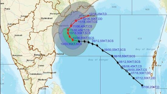
Asani, which means wrath in Sinhala, is likely to move northwestwards and reach west central Bay of Bengal close to Kakinada-Vishakhapatnam coasts by Wednesday morning. Thereafter, IMD said, Asani is likely to recurve slowly north-northeastwards and move along Andhra Pradesh coast between Kakinada and Vishakhapatnam and then emerge into northwest Bay of Bengal off North Andhra Pradesh and Odisha coasts.
Asani is likely to weaken gradually into a cyclone by Wednesday morning and into a depression by May 12 morning but before it weakens, it is forecast to cause intense rainfall and extremely strong winds along Andhra Pradesh and Odisha coasts.
On Tuesday afternoon Asani lay centered around 210 km south-southeast of Kakinada (Andhra Pradesh), 310 km south-southwest of Visakhapatnam (Andhra Pradesh), 530 km southwest of Gopalpur (Odisha) and 630 km southwest of Puri (Odisha).
The model predictions were looping indicating high uncertainty about the track of Asani, scientists said.
{{/usCountry}}The model predictions were looping indicating high uncertainty about the track of Asani, scientists said.
{{/usCountry}}“As you can see track has changed now. Asani will touch and move along the Andhra Pradesh coast between Kakinada and Visakhapatnam. We are now expecting Asani to touch the coast on Wednesday early morning. The impact may not be very severe but still, people need to be prepared,” said Ananda Kumar Das, in-charge of the weather bureau’s cyclone monitoring division.
“The system was moving slowly but its weakening was expected. But during the past many hours, its size became smaller which has helped Asani to retain its energy and intensity. Model predictions had started looping indicating very high uncertainty of track. This means anything can happen. Now a red warning has been issued for Andhra Pradesh coast,” he added.
Storm surge of height of about 0.5 m above astronomical tide is likely to inundate low lying areas of Krishna, East and West Godavari and Vishakhapatnam districts of Andhra Pradesh, IMD has warned.
Moderate rainfall at many places with heavy to very heavy rainfall at isolated places is likely over coastal Andhra Pradesh and Odisha is likely from May 10 night.
On Wednesday, moderate rainfall at most places with heavy to very heavy rainfall at a few places and isolated extremely heavy rain (over 20 cm) is likely over coastal Andhra Pradesh and heavy rainfall at isolated places is likely over coastal Odisha and adjoining coastal West Bengal.
On Thursday, moderate rainfall is likely at a few places with heavy rainfall at isolated places over coastal areas of Odisha and West Bengal.
Gale wind speed reaching 100-110 kmph gusting to 120 kmph is prevailing around the system centre over westcentral Bay of Bengal. It will gradually decrease, becoming 85-95 kmph gusting to 105 kmph over west central and adjoining northwest Bay of Bengal from midnight of Tuesday and become 75-85 Kmph gusting to 95 Kmph from the morning of Wednesday over the same region. Further, it will decrease to 55- 65 Kmph gusting to 75 kmph over north west and adjoining west central Bay of Bengal from Wednesday morning.
Squally wind speed reaching 45-55 kmph gusting to 65 kmph is prevailing along and off Andhra Pradesh coast. It is likely to increase, becoming 55-65 kmph gusting to 75 kmph from early hours of Wednesday and gale wind speed reaching 75-85 kmph gusting to 95 kmph during morning to noon of May 11 along and off Andhra Pradesh coast (Krishna, East & West Godavari and Visakhapatnam districts). Squally wind speed reaching 45-55 kmph gusting to 65 kmph is likely to continue along and off Odisha coast till Thursday and along and off West Bengal coast on Wednesday and Thursday.