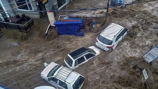
At least seven people died and many more were reported missing on Wednesday after a cloudburst caused flash floods in Jammu’s Kishtwar district. Nine people died and seven reported missing in two separate flash floods in Kullu and Lahaul-Spiti districts of Himachal Pradesh, officials of the state disaster management authority said on Wednesday. Last week, several parts of Konkan reported what scientists termed mini-cloudbursts leading to flooding of rivers, damage to infrastructure and the death of at least 100 people. And at least 10 cars were washed away when a flash flood triggered by a suspected cloudburst swept through Bhagsunag locality near McLeodganj in Himachal Pradesh on July 12.
This monsoon has seen a spate of cloudbursts and mini cloudbursts over the Western Himalayas and the west coast revealing the deadly, unpredictable face of monsoon rains. There has been a sharp increase in cloudburst incidents in the past few years according to the India Meteorological Department (IMD), although the agency has not conducted an analysis of cloudburst incidents specifically but observed trends from media reports and data on heavy and extremely heavy rainfall events that it documents.
A cloudburst is when 10 cm or more rainfall is recorded at one station in one hour according to IMD. “When moisture availability is very high large deep clouds develop and the droplets, they form can be both big and very high in number. Cloud efficiency can go up in many cases leading to cloudburst incidents,” said M Rajeevan, secretary, ministry of earth sciences.
He added that it was likely their numbers were increasing. “We know that incidence of heavy rainfall events is going up, and along with that cloudburst numbers are also likely to be increasing as an impact of climate change.”
It is very difficult to predict a cloudburst because of its very small scale in space and time. To even nowcast such events, experts said, IMD may require a very dense radar network in cloudburst prone areas such as the Western Himalayas. Nowcasts are predictions of the present or the very near future.
“IMD has about 150 weather stations from where hourly rain data can be accessed. But all regions are not covered. IMD has no specific analysis on cloudbursts. Overall higher water vapour availability due to climate change may have led to a rise in cloudbursts,” Rajeevan explained.
{{/usCountry}}“IMD has about 150 weather stations from where hourly rain data can be accessed. But all regions are not covered. IMD has no specific analysis on cloudbursts. Overall higher water vapour availability due to climate change may have led to a rise in cloudbursts,” Rajeevan explained.
{{/usCountry}}There has been a rise in short span high intensity rain occurrences (mini cloud bursts) along the west coast of India and along the foothills of Western Himalayas between 1969 and 2015 according to “Assessment of Climate Change over the Indian Region,” a report by the union ministry of earth sciences published last year.
Scientists have also said even if heavy rainfall events don’t meet the exact criteria defined, but cause extensive damage such as flash floods and landslides in high altitude areas, they should also be considered cloudburst events. A paper authored by including those from scientists at the Indian Institute of Tropical Meteorology titled ‘Statistical characteristics of cloud burst and mini-cloud burst events during monsoon season in India’ published in International Journal of Climatology categorised cloudbursts in to three categories.
The first, CBa events are associated with heavy rainfall in the mountainous regions of Himalayas identified based on flash floods and damage to properties and human losses, irrespective of the rainfall amount.
The second, CBb events are associated with rainfall in excess of 10 cm per hour as per the definition of IMD.
The third, are mini-cloudbursts (MCBs), where the rainfall in two consecutive rain-hours is 5 cm or more. MCBs typically occur in June over the Western Ghats;and in July and August over central India and the foothills of Himalayas. Trend analyses indicate significant increase in these events at many places, except over northeast India, the paper said.
“We know that these incidents both in plains and hills are being reported frequently. This year they have been reported in Mumbai and Konkan region. In 2019 also there were several cloudburst incidents. Since they cannot be predicted people need to be better prepared during monsoon months. In 2005 Santacruz in Mumbai reported 38 cm rain in 3 hours. It was clearly a CB led flooding. Something similar had happened in 2013 in Uttarakhand also. They have a potential for extensive damage of life and property,” said a co-author of the IITM paper who asked not to be named.
“Cloudburst events were not common in Kerala though Kerala records monsoon days with moderate continuous kind of rain spanning through the day. But in recent years we are seeing some changes in cloud structure. We did an assessment of 2018 and 2019 floods in Kerala. While the 2018 floods saw more continuous kind of rain, during 2019 we saw very deep clouds up to 12 to 14 km which is not common here. When such clouds form after a long dry spell over a region, they bring an extremely intense downpour in a few hours. They probably develop because the thermal potential is very high but they can cause very severe damage in Kerala and the Konkan region,” explained S Abhilash, director, Advanced Centre for Academic Radar Research (ACARR) at Cochin University of Science and Technology.
Mumbai’s Santacruz and Colaba recorded extremely heavy rainfall, 23.4 cm and 19.68 cm rain on July 17 and 18 in the span of five to six hours triggering urban flooding and devastation.
“We need a dense rain gauge network and hourly rain data to document all cloud burst and mini cloudburst events. We know from media reports that this year the number of such events may be higher than usual, but the exact figure is not there. Several such events have occurred this year in Uttarakhand, Himachal Pradesh and Maharashtra,” said RK Jenamani, senior scientist, national weather forecasting centre of IMD.
While cloudburst incidents are less likely to be captured in IMD’s grided dataset, this data does show an increase in heavy and extreme rainfall events. Rainfall of 35.5 mm to 244.5 mm in a 24-hour period in a grid (box bound by two latitudes and longitudes 0.25 degrees apart) is classified as heavy, while that above 244.5 mm is classified as extreme. Average heavy and extreme rainfall during the June-September monsoon season was 376.5 mm in the 2011-2020 decade, compared to 363.4 mm in the long period average or the average of such rainfall in the 1961-2010 period. This amounts to a 3.63% increase. In comparison rainfall of lesser intensity than heavy or extreme rain has increased only 0.35% compared to the LPA. A district-wise analysis shows that heavy and extreme rainfall has increased more in the peninsular and north-western regions of the country.
(Abhishek Jha contributed to this story)