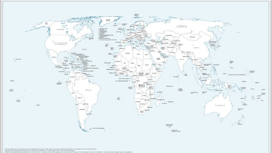
The United Nations has released a new world map that shows Arunachal Pradesh and Aksai Chin, which India affirms is a part of Ladakh, as separate regions lying between the “claim lines” of India and China. India had supported the map-related 'Correct the Map' resolution adopted by the UN General Assembly on September 4.
At a press briefing on Tuesday, the ministry of external affairs (MEA) reiterated India's position on the map, saying that New Delhi had voted for the resolution since it deals with the use of equal-area maps and does not approve any map produced by a private party or a specific entity.
What UN’s new world map shows
The map was initially released on July 1, as discussions were taking place on the UNGA resolution. In its depiction of Arunachal Pradesh, the map removes the state's boundary with Nagaland and shows it as a separate state, with Assam and China on either side.
{{/usCountry}}The map was initially released on July 1, as discussions were taking place on the UNGA resolution. In its depiction of Arunachal Pradesh, the map removes the state's boundary with Nagaland and shows it as a separate state, with Assam and China on either side.
{{/usCountry}}Notably, Aksai Chin has also been shown as a separate region. The United Nations has not given any explanation for these changes.
Jammu and Kashmir has been shown with a dotted line marking the Line of Control (LoC) between India and Pakistan.
The map also carries a note on its left side about the LoC. It says that the “dotted line represents approximately the Line of Control in Jammu and Kashmir agreed upon by India and Pakistan. The final status of Jammu and Kashmir has not yet been agreed upon by the parties.”
The United Nations General Assembly approved an African Union-backed resolution last week called "Correct the Map". The resolution seeks more accurate and fair representation of different parts of the world on maps, with a particular focus on Africa.
What India said on UN’s new world map
MEA spokesperson Randhir Jaiswal said on Tuesday that India's support for the resolution was based on its focus on equal-area maps and did not amount to approval of any particular map.
“...we favoured the resolution and voted in favour of the resolution. When the resolution was adopted in the UN General Assembly, we also made a statement where we clarified our position...The resolution is focused on the principle of equal-area maps. It does not endorse any map of any private party or any particular entity,” he said.
He added, “The resolution is focused on the principle of having, giving weightage or giving credence to equal-area maps, so that, as we have said, the equal-area maps project or preserve the relative sizes of continental landmarks."
The MEA spokesperson had earlier said that India's vote in favour of the map was based on “the underlying principle of promoting equal-area cartographic representation.”
However, New Delhi made it clear that the Equal Earth map should not alter how existing national borders are shown.
"India’s sovereign territory, including the Union Territories of Jammu and Kashmir and Ladakh, must be depicted in accordance with India’s official map. Any inaccurate or misleading depiction is unacceptable. Our position on India’s sovereignty and territorial integrity is clear, consistent and non-negotiable," Jaiswal added in the statement.