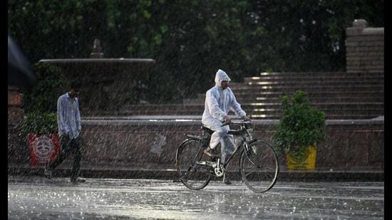
LUCKNOW Relentless and non-stop showers lashed Lucknow for nearly 24 hours, starting Thursday evening and extending straight through Friday evening, leaving major parts of the city thoroughly drenched. The Lucknow airport Met station recorded a staggering 86.6mm of rainfall in 12 hours, from 8:30am to 8.30pm on Friday, following an initial 10.5mm logged in the 24 hours leading up to Friday morning, the weatherman said.
The state government put the district administrations on alert in view of the forecast of heavy rain, thunderstorms and lightning till September 27.
The heavy downpour cooled the city, forcing the maximum temperature down to 23.5 degrees Celsius and the minimum to 22.4 degrees Celsius—resulting in a remarkably narrow temperature variation of just 0.9 degrees.
In Lucknow, the IMD forecast overcast conditions, strong surface winds and intermittent spells of rain or thundershowers. The maximum and minimum temperatures are expected to remain around 24 and 22 degrees Celsius, respectively. Thunderstorms, lightning and heavy to very heavy rain accompanied by gusty winds of 40-50 kmph are likely at isolated places.
In wake of inclement weather, the district administration announced that teaching work will remain suspended on Saturday (September 26) in all government/non-government aided/private schools from pre-primary to Class 12 in all urban and rural areas of the district, said district magistrate (Lucknow) Vishak G.
Teaching work will also remain suspended in all higher educational institutions/technical colleges/professional colleges/government polytechnics and government ITIs of Lucknow on Saturday in view of bad weather conditions.
{{/usCountry}}Teaching work will also remain suspended in all higher educational institutions/technical colleges/professional colleges/government polytechnics and government ITIs of Lucknow on Saturday in view of bad weather conditions.
{{/usCountry}}Rain resulted in a sharp drop in day temperature in the state capital and adjoining areas. For instance, on Wednesday, Lucknow’s maximum temperature was 34.3 degrees that plummeted to 29.6 degrees on Thursday. The day temperature dropped further to 23.5 degrees – 9.7 degrees below normal – on Friday. Thus the overall drop in day temperature was 10.8 degrees in 48 hours.
Barabanki recorded the lowest day temperature in the state at 23 degrees, followed by Hamirpur 23.2 and Lucknow at 23.5 degrees.
Uttar Pradesh is likely to witness an increase in rainfall activity over the next two days, the India Meteorological Department said on Friday, warning of heavy to very heavy rain at several places and extremely heavy rain at isolated locations.
The weather system, caused after a deep depression over the Bay of Bengal crossed the north Andhra Pradesh-south Odisha coast and moved North-West, is likely to maintain its intensity for the next 12 hours before gradually weakening into a well-marked low-pressure area during the subsequent 12 hours, according to the weather bulletin.
According to the forecast, west UP is likely to receive rain and thundershowers at many places on September 25 and 26, accompanied by strong surface winds. East UP is expected to experience rain at most places on September 25-26, with heavy to very heavy rainfall and isolated extremely heavy rain during this period.
The weather department warned that intense rainfall could trigger flash floods in some watersheds of the state. Strong surface winds are also likely to accompany the rain, with speeds of 30-40 kmph and gusts reaching around 50 kmph, while gusty winds of 40-50 kmph, occasionally reaching 60 kmph, are possible at isolated places.
Concurrently, a significant drop of 4–7°C in the state’s maximum temperature is expected over the next 48 hours.
Banda recorded the highest rainfall at 146mm, followed by Bahraich 103.6mm, Barabanki 62.4 mm, Hamirpur 54 mm, Hardoi 37mm, Lakhimpur Kheri 35mm, Shahjahanpur 33.8mm and Kanpur city 32.2mm.
UP RAINFALL DEFICIT AT 5%
Uttar Pradesh has received 699.7mm rainfall against the long period average (LPA) of 735.3 mm, leaving the state with a 5% deficit, which falls in the normal category.
East UP recorded 712.3mm rainfall against an average of 784.2 mm, a deficit of 9%, while west UP received 681.7mm against an average of 666.7 mm, a surplus of 2%.
So far, 25 districts have recorded deficit or large deficit rainfall. 35 districts have received normal rainfall, while 15 districts have recorded excess or large excess rainfall this season. The withdrawal of monsoon began from west UP on Wednesday.
Red alert in 8 dists, orange alert in 13
IMD issued a red alert for Saturday, which signifies likelihood of very heavy to extremely heavy rain in eight UP districts: Shravasti, Bahraich, Lakhimpur Kheri, Sitapur, Rampur, Bareilly, Pilibhit, Shahjahanpur, and surrounding regions.
There is a high probability of heavy to very heavy rainfall in 13 districts: Lucknow, Barabanki, Badaun, Hardoi, Siddharthnagar, Gonda, Balrampur, Moradabad, Amroha, Sambhal, Bijnor, Basti and surrounding regions.
Yellow alert in over 35 districts
There is a high probability of heavy rainfall (yellow alert) in over 35 districts including Kanpur Dehat, Kanpur City, Unnao, Rae Bareli, Kaushambi, Mau, Prayagraj, Fatehpur, Pratapgarh, Sonbhadra, Mirzapur, Chandauli, Varanasi, Jaunpur, Ghazipur, Azamgarh, Ballia, Gorakhpur, Kushinagar, Maharajganj, Farrukhabad, Kannauj, Sultanpur, Ayodhya, Ambedkar Nagar, Saharanpur, Shamli, Muzaffarnagar, Meerut, Hapur, Bulandshahr, Kasganj, Mainpuri, Etawah, and surrounding areas.
Moderate risk of flash floods in 30 districts
There is a moderate risk of flash floods in specific watersheds in over 30 districts including Lucknow, Unnao, Kanpur City, Rae Bareli, Barabanki, Sitapur, Ballia, Azamgarh, Ghazipur, Maharajganj, Kushinagar, Deoria, Gorakhpur, Sant Kabir Nagar, Mau, Siddharthnagar, Balrampur, Ambedkar Nagar, Pratapgarh, Sultanpur, Ayodhya, Gonda, Shravasti, Kheri, Bahraich, Hardoi, Amethi, Basti, Fatehpur, Banda, Kaushambi, and Chitrakoot.