Rivers across Uttarakhand were flowing above the danger mark on Wednesday, triggering fears as heavy rainfall continued in parts of the state, a day after suspected cloudbursts led to flash floods along the Kheer Ganga river banks and left at least four dead and dozens missing in Uttarkashi.
Officials said disaster response teams were on high alert and authorities were monitoring the situation closely, especially in low-lying and vulnerable areas near the riverbanks.
The India Meteorological Department has forecast heavy rainfall for the next four days in isolated places across the state, prompting authorities to urge people to remain cautious and avoid venturing near riverbanks until water levels recede.
The Central Water Commission said that four rivers at five sites remained in a “severe flood situation,” meaning water levels were between the danger and the highest flood levels.
The five rivers included the Alaknanda, which was flowing at 627.6 metres, 0.60 metres above the danger mark of 627.0 metres, in Rudraprayag at 6am. The level was 7.25 metres below the historical high of 634.85 metres, recorded during the 2013 floods.
The Mandakini river, which wreaked havoc in 2013, was flowing at the danger mark of 1976.8 metres, at Gaurikund. It remained 0.55 metres below its previous highest flood level of 1977.35 metres on June 17, 2013. The river was flowing at 626.3 metres, 0.30 metres above the danger mark, in Rudraprayag, with a falling trend of -299.99 mm/hour.
{{/usCountry}}The Mandakini river, which wreaked havoc in 2013, was flowing at the danger mark of 1976.8 metres, at Gaurikund. It remained 0.55 metres below its previous highest flood level of 1977.35 metres on June 17, 2013. The river was flowing at 626.3 metres, 0.30 metres above the danger mark, in Rudraprayag, with a falling trend of -299.99 mm/hour.
{{/usCountry}}As of 6am, the Banganga at Raysi in Haridwar was flowing at 231.69 metres, 0.69 metres above the danger level, with a rising trend of 40.01 mm/hour. The river was now 1.71 metres below its historical peak of 233.4 metres on June 18, 2013.
In Tehri Garhwal district, the Bhagirathi at Devprayag was flowing above the danger mark. At 6am, the river level was 464.3 metres, 1.30 metres above the danger level of 463.0 metres. The water levels remained steady, though still well below the previous highest flood level of 474.5 metres, in 2013.
In 2013, flash floods in Kedarnath killed 4,127 people, the worst disaster in the state. In 2021, a glacier burst triggered an avalanche in Chamoli, killing over 200.
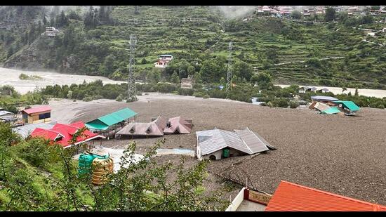
Rescue teams were combing the hills of Uttarkashi for survivors after suspected cloudbursts triggered flash floods in a cluster of villages on Tuesday. Boulders, debris, and mud barrelled through Dharali, demolishing houses, shops, and hotels.
The army, State Disaster Response Force, and police rescued 70 people until midnight. The continuing rain and treacherous terrain hindered rescue efforts.
Visuals showed mud and water barrelling through the Kheer Ganga river, tearing down trees, before hitting buildings, power lines, and vehicles. Videos showed people desperately running for cover or to higher ground as the torrents washed away several.
The flash floods formed a lake, the waters of which overflowed and endangered surrounding areas. Climate change and environmental degradation have triggered a string of disasters in Uttarakhand over the last few years.