The 30-member expert team succeeded in widening the mouth of the lake, formed upstream Rishiganga river in Uttarakhand’s Chamoli district due to flash floods, by about 15 feet, leading to faster drainage, which is likely to prevent a repeat of the tragedy, according to state disaster response force (SDRF) commandant Navneet Bhullar.
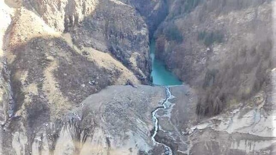
“In a daring effort, the team has widened the mouth of the lake in a very difficult terrain, which has increased the discharge from the lake. Due to this, the chances of lake burst or Chamoli-like tragedy happening again have been averted. And our team members are still camping there to try to widen the mouth further,” Bhullar said.
An avalanche triggered by a glacier burst over upper Himalayan regions in Chamoli district on February 7 damaged two hydel power projects on Rishi Ganga river and possibly killed 150 people. The sludge from the flash flood also blocked the flow of Rishiganga and created a lake which experts fear could burst to create another tragedy. Scientists, Indian military personnel, Indo Tibetan Border Police (ITBP) and disaster management personnel and experts analysed the lake including its depth before widening its mouth proportionately from 20 feet to around 35 feet.
“The special equipment, quick deployable antenna (QDA) based on satellite communication, has been set up there and it is helping us to have real-time communication with the expert team,” Bhullar added.
{{/usCountry}}“The special equipment, quick deployable antenna (QDA) based on satellite communication, has been set up there and it is helping us to have real-time communication with the expert team,” Bhullar added.
{{/usCountry}}The expert team formed by state chief secretary Om Prakash, includes scientists from the Uttarakhand Space Application Centre and Geological Survey of India, apart from officers from ITBP and SDRF. They had left for the lake area on Friday and reached there on Saturday.
When inputs first came that a lake was forming again upstream Rishiganga, SDRF's eight-member high altitude rescue team (HART), which included six persons who had scaled Mount Everest in 2018 and Navneet Bhullar, was sent to the area for ground survey. The team sent one of its members, Manoj Joshi, to widen the lake mouth to some extent. He succeeded in widening it by around six feet, with the help of a rope.
Also Watch: Navy divers, in IAF helicopter, measure glacial lake depth in Tapovan
“It was a very dangerous incline and widening it (the lake mouth) was difficult. I could widen it by a few feet only,” said Manoj Joshi, an Everest summiteer, Joshi.
On Sunday, a quick deployable antenna (QDA) was flown to the lake area in a chopper for the expert team to communicate from the remote terrain. Earlier on Saturday, an air force chopper took two navy divers to the lake to measure the depth of the lake. They used their hand-held echolocation devices for measuring the depth, found to be around 8 to 9 metres, according to SDRF DIG Ridhim Aggarwal.