
 E-Paper



Global warming throws India’s monsoon patterns out of gear
The monsoon directly affects 51% of India’s farmed area, accounting for 40% of agricultural production

 Prefer HTon Google


India’s southwest monsoon, the economic lifeline for nearly half a billion people, is becoming increasingly unpredictable as global warming weakens traditional circulation patterns while the increased moisture due to a warming planet triggers more extreme weather events.
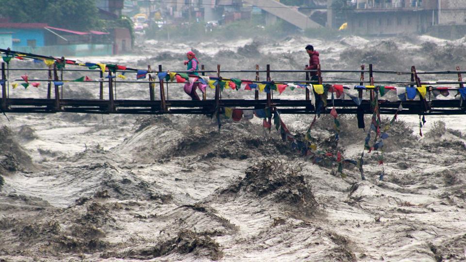
Recent monsoon disasters in Himachal Pradesh, Uttarakhand and Jammu and Kashmir have provided a glimpse of what India faces in coming decades, scientists warn.
The monsoon directly affects 51% of India’s farmed area, accounting for 40% of agricultural production, with 47% of the population dependent on agriculture for their livelihood.
To understand how the monsoon has changed, it’s essential first to grasp how this weather system normally operates: Following summer heating of the Indian landmass relative to the cooler Indian Ocean to its south, pressure gradients drive winds that carry ocean moisture across India. This system has been a stable feature of South Asian climate for millennia.
Weaker, but wetter
A study by M Rajeevan, former secretary of India’s ministry of earth sciences, and climate scientists Parthasarathi Mukhopadhyay and Arindam Chakraborty found that monsoon circulation has weakened.
But their research also reveals a climatological paradox is taking hold: Even as the monsoon winds weaken, rising temperatures are increasing atmospheric moisture, creating more frequent dry spells alternating with more intense wet spells.
“Heavy precipitation events are going to increase in future,” said Rajeevan, lead author of the Elsevier-published study “South Asian Summer Monsoon: Processes, Prediction and Societal Impacts”.

In other words, the same amount of rain now falls in more extreme bursts separated by longer dry periods, rather than steady, predictable patterns. The study projects this volatility will worsen, with more frequent extreme rainfall events and droughts. Even the El Niño-monsoon relationship is weakening, undermining seasonal forecasting.
El Niño, a climate pattern characterised by warming of sea surface temperatures in the central and eastern Pacific Ocean, typically reduces monsoon rainfall over India by altering global atmospheric circulation patterns.
“The main issue which we should all worry about in terms of disaster management or economic impacts is extreme weather events and extreme precipitation events,” Rajeevan added.

Surface air temperatures over the South Asian monsoon region have risen by about 1°C during 1981-2022, according to Rajeevan’s research. Under basic physics principles, each degree of warming allows air to hold 7% more water vapour.
A 2017 study by the Indian Institute of Tropical Meteorology linked rising sea levels over the North Indian Ocean to weakening monsoon circulation over recent decades.
Climate scientist Roxy Mathew Koll explained the mechanism: “Increased warming in the ocean enhances large-scale upward motion of warm moist air over the equatorial ocean. This enhanced upward motion is compensated by subsidence of dry air over the subcontinent, inhibiting convection and rainfall over the Indian landmass.”
Geographic patterns shift
Another result of these shifts is a dramatic change in spatial distribution of monsoon rainfall. Analysis of trends from 1951-2022 shows extreme rainfall events increasing across most of central and western India, including Gujarat, and the northwestern Himalayas.
However, the frequency of moderate and heavy rain has decreased over central India’s core monsoon region in this period.
The changes extend beyond India’s borders: monsoon rainfall shows decreasing trends over Nepal and Bangladesh, while Pakistan has experienced increasing monsoon rainfall in recent decades.
Humid heat
An India Meteorological Department study covering 1989-2018 found “significant decreasing trends” in southwest monsoon rainfall across Ganga basin states including Uttar Pradesh, Bihar and West Bengal - areas with some of the country’s most fertile land.
Meanwhile, heavy rainfall days (6.5cm or more) increased significantly in Gujarat’s Saurashtra and Kutch regions, southeastern Rajasthan, northern Tamil Nadu, northern Andhra Pradesh and parts of Chhattisgarh and Madhya Pradesh.
Humid regions are becoming drier and dry regions are becoming wetter, researchers noted, with statistically significant increases in both the frequency of dry spells and intensity of wet spells.
“It rains, and then we have a break, then we have another spell and another long break. But during the break, moisture content is more. You can expect higher heat stress than earlier years during the monsoon,” Rajeevan explained.
Cloudburst challenge
A critical gap remains in forecasting cloudbursts -- localised phenomena producing 100mm of rain per hour that increasingly threaten mountain communities.
“Cloudbursts are seemingly intensifying, taking lives, but we do not have efficient monitoring or forecasting of these events. We need to fill this gap now,” said Koll.
The events often occur in remote areas lacking rain gauges or radar coverage, making immediate verification difficult for authorities.
Health implications
The changing monsoon patterns are expanding disease risks. Research by Koll, Sohia Yacob and colleagues from the Indian Institute of Tropical Meteorology and IIT Bombay found that temperatures above 27°C combined with moderate rainfall and humidity levels of 60-78% during the June-September monsoon season increases dengue incidence and deaths.
Heavy rains above 150mm per week reduce dengue prevalence by flushing out mosquito eggs and larvae.
Projections for 2021-2040 suggest rising temperatures could increase dengue cases and mortality by 12-22%, though extreme monsoon rains may offset this by 3-4% through their flushing effect.
Future projections
Climate models consistently project increases in both mean monsoon rainfall and its variability across South Asia by the century’s end, despite continued circulation weakening.
The traditional relationship between the El Niño Southern Oscillation and monsoon patterns is also likely to weaken, impacting seasonal forecasting capabilities.
The Southern Oscillation refers to changes in air pressure between the eastern and western Pacific Ocean that drive El Niño and La Niña cycles, historically used to predict monsoon strength months in advance. El Nino years sap the monsoon, while La Nina conditions tend to augment rainfall.
“Monsoon will become very erratic and that will make it very difficult for farmers. Though mean rainfall is expected to increase,” Rajeevan said.
The changes represent a fundamental shift in one of the world’s most stable climate features, with implications extending far beyond agriculture to urban planning, disaster preparedness and public health across the subcontinent.



