If you grew up in the 1980s you might remember the environmental movement as almost benign. Sure, the world was a bit of a mess, but we could save it. All we had to do was recycle our garbage, pick paper over plastic and repair the hole in the ozone layer. The problem was solvable.
In the decades since, shifting terminology has traced the escalation, from greenhouse gases to climate change to a climate crisis. Nothing has been left untouched.
If you grew up in the 1980s you might remember the environmental movement as almost benign. Sure, the world was a bit of a mess, but we could save it. All we had to do was recycle our garbage, pick paper over plastic and repair the hole in the ozone layer. The problem was solvable.
In the decades since, shifting terminology has traced the escalation, from greenhouse gases to climate change to a climate crisis. Nothing has been left untouched. Parts of Antarctica are now more than 40 degrees Celsius warmer than average. Animals are evolving to survive. This year has been marked by record-setting droughts in Europe, and record-setting floods across the Indian subcontinent.
In Iraq’s Kurdistan region, receding waters diverted from a reservoir exposed the ruins of a Bronze Age city forgotten for 3,400 years. In Chongqing, China, the Yangtze has receded to reveal ancient statues on an island reef. In Italy, villages submerged decades ago stand roofless and surprised, as the reservoirs that drowned them dwindle. Gold Rush-era settlements and bodies in barrels have emerged on the beds of shrinking lakes in the US.
There’s a term for it at the Poles: glacial archaeology. Here, finds include Antarctic explorer Ernest Shackleton’s sunken ship, the Endurance.
View a gallery of images here. Read on for more on each site
“The climate crisis is not a future problem. It’s very much a problem of the present,” says Nagraj Adve, member of Teachers Against the Climate Crisis (TACC), an autonomous network of researchers and university-level educators. “But anxiety and panic are not useful. They lead to inaction, not action.”
Already, scientists warn of apocalypse fatigue, in which individuals and communities are so overwhelmed by the escalating crisis that they believe the cause is already lost. Adve’s 2019 booklet, Global Warming in the Indian Context: An Introductory Overview, helps students and teachers make sense of the crisis, and their continuing role in shaping humanity’s future within it.
Adve’s booklet offers an on-ground look at who is worst affected by climate change (small farmers, women labourers, coastal communities) and how impacts have worsened since the 1970s. It explains what increased household consumption, loss of tree cover and a warming Earth means for our shared future. The booklet has been translated into Hindi, Gujarati, Kannada, and Tamil, with an Odia edition due for release soon.
The big reveal
So what does a warming Earth means for our shared future? Global warming — measured as the change in average annual temperature from pre-industrial levels before 1850 — has crossed the 1.2-degree-Celsius threshold. This means superstorms, climate anomalies, wildfires and floods will intensify in parts of the world that house over half the global population.
Approximately 3.5 billion people stand to be affected, according to estimates from the sobering second part of the sixth assessment report released by the United Nations Intergovernmental Panel on Climate Change (IPCC) in February . The panel, which has been producing climate-change reports since 1990, mentioned colonialism for the first time this year, speaking of “development challenges” that make former colonies more vulnerable to climate impacts.
Some of those nations are speaking out. At the Cop26 climate talks in Glasgow in 2021, Barbados prime minister Mia Mottley urged leaders of the developed world to “try harder” to avert catastrophe. A world overheating even by 2 degrees Celsius is a “death sentence” for the people of the low-lying countries of Maldives, Antigua, Barbados, Fiji, Kenya, Mozambique, Samoa, she said.
The new goal is to stabilise global warming, using a net-zero approach that seeks to cap carbon dioxide emissions at current levels. Even this will require compromises and sacrifices by the Global South, to fix a problem that has historically been the product of the Global North.
India, at the Cop26 summit, announced a commitment to cut its emissions to net-zero by 2070. The US and EU’s target is 2050.
In many ways, it’s an uphill task. Earth’s melting north and south poles are already destabilising the climate system. New data from 40 years of satellite observations across India, China, Nepal and Bhutan, has found that Himalayan glaciers have been melting twice as fast since the start of this century. This “third pole” has lost the equivalent of more than a vertical 1.5 feet of ice every year since 2000. The retreating ice will intensify climate anomalies and affect about 800 million people who depend on meltwater to sustain their rivers.
Rising sea levels already directly threaten Mumbai, Surat, Kolkata, Chennai, Kochi, some of India’s richest and most populous cities. Groundwater is fast depleting.
“Tech can only solve parts of the problem,” Adve says. And even the tech for that isn’t ready yet. Cloud seeding, machines that suck vehicular pollution from the atmosphere, even smokeless crop-waste burners are not tested for scale.
Come cities are finding new ways forward, replacing fossil fuels with greener wind and solar energy, across entire towns and industrial belts. In Saudi Arabia, a new city, Neom, is being constructed as a 170-km strip of low-rise structures for work, life and entertainment, powered by wind and solar energy and connected via an underground mass transit network. In the US, Telosa, a city of electric-only cars, walkways, e-scooters and mass transit, plans to house 5 million people by 2050.
Adve says that people typically “start to join the dots and take notice when climate events get more frequent, closer to home; when you feel the heat and the food starts to become scarcer and more expensive”. That’s starting to happen, and Adve believes it will prompt the public to push harder for climate-friendly policies over token efforts at greening and green certification.
We know more now than we did in the 1970s. Environmental concerns no longer seem benign.
“We are at the start of a long curve of climate impact,” Adve says. “Sea levels alone will continue to rise for hundreds of years, no matter what we do today. We must live with the idea that the change is long-term.”
- Rachel Lopez
.
RUINS REVEALED BY DROUGHT
Around the world, amid some of the harshest summer temperatures on record, dwindling rivers and drying lakes have thrown up visions of the past and future: ancient ruins, hunger stones inscribed in long-ago famines, villages that sat on the beds of reservoirs. Take a look.
Kurdistan Region, Iraq: Bronze Age ruins in a reservoir
It was a race against time. As water was diverted from the Mosul reservoir to the drought-stricken region of southern Iraq in January, archaeologists began an emergency excavation. Because as the waters receded, the ruins of a 3,400-year-old city emerged here, not far from the Tigris River.
The settlement is thought to be the ancient Zakhiku, a key city in the Mittani Empire (c. 1550 to 1350 BCE). The emergency digs were conducted over seven weeks, by researchers from the Kurdistan Archaeology Organization, and Germany’s University of Freiburg and University of Tübingen. Then the area was flooded again.
In that time, the researchers uncovered the remains of walls and foundations, a massive fortification, multi-storey warehouses, ruins of a palace, and ceramic vessels that contained scores of remarkably-well-preserved tablets covered in cuneiform (the oldest written script), some still within their clay envelopes.
“It is close to a miracle that cuneiform tablets made of unfired clay survived so many decades under water,” Peter Pfälzner, an archaeologist with the University of Tübingen, said in a press release.
Deciphering the cuneiform tablets could reveal what life was like in Zakhiku. Similar tablets found elsewhere, such as those bearing writing in Demotic, uncovered in Egypt, have contained intriguing daily minutiae such as shopping lists, sales records and students’ homework.
.
Texas, US: Even fossils feel the heat
About 113 million year ago, an acrocanthosaurus strolled along what was possibly a seashore in present-day Texas, and left behind some of the best-preserved dinosaur footprints ever found: a whopping 140 tracks along a 100-ft stretch. They’re calling it the Lone Ranger Trackway.
A megadrought in the southern US state has revealed these prints in the dried-up riverbed of the Paluxy River that runs through central Texas. The massive footprints, situated within the Dinosaur Valley State Park, have not been seen since 2000.
“Though we have acrocanthosaurus tracks visible in the park year-round, we have never seen the tracks this clean and viewable all at one time,” Paul Baker, retail manager with LDL Friends of Dinosaur Valley, a non-profit set up to support the park, told Wknd. “Many new tracks were found and mapped by researcher Glen Kuban. People heard, and flocked to the park. We had lines of cars trying to get in.”
The trail is most likely the work of a single acrocanthosaurus, most likely 15 ft tall, weighing seven tonnes. The two-legged, three-toed apex predator lived in the Early Cretaceous period (about 50 million years before its more famous cousin, the tyrannosaurus rex).
Over several days, as water levels stayed low, dozens of volunteers and citizen scientists shoveled and swept, using leaf blowers, buckets and scoops to tidy the mud and sediment around the exposed tracks. Together with the researchers working on the site, they mapped over 300 footprints in all, from a range of dinosaur species. Most of the prints are sharp and deep. Some have been identified as those of a sauroposeidon, a 60-ft-tall herbivorous dinosaur. Many of the tracks have been 3D imaged, to create models for future studies.
“Among the more interesting newly documented tracks was the ‘track in track’ (a raised, well infilled track with distinct digits inside one of the deep mud-collapsed long trail tracks),” says Kuban.
Most of the world’s dinosaurs were wiped out by extreme climate change caused by the Chicxulub impactor, an asteroid or comet that caused tidal waves, a global winter, and left as it mark a crater off the coast of Mexico that spans 93 miles and is 12 miles deep.
.
Caceres, Spain: Sunken rocks from a land time forgot
Spain is experiencing its worst drought in decades. At the Valdecañas reservoir in the central province of Caceres, water levels dropped to less than 30% of holding capacity. As they dropped, they revealed the Dolmen of Guadalperal: 144 megalithic stones, arranged like a sort of Stonehenge, dating to about 5000 BCE.
The dolmens are 6 ft in height, arranged in concentric circles. Archaeologists from Madrid’s Complutense University are racing to study the site. “Guadalperal was funerary mound,” says Enrique Cerrillo-Cuenca, an associate professor in prehistory at Complutense, who first examined the site when it emerged in 2019. “A dolmen is formed by a burial chamber and a corridor that gives access to it. They are a really common archaeological feature in European landscapes, dated between 4500 and 2200 BCE.”
Archaeologists are in the process of studying how and when it was built, and what links it might have to a network of prehistoric settlements in the region.
The Dolmen of Guadalperal was discovered by a German archaeologist in 1926, it has been submerged since the 1960s, after the area was flooded in a rural development project. The site has shown itself only four times since. Now, the water is erasing some of the carvings on the stones and there is talk of moving the arrangement out of the reservoir.
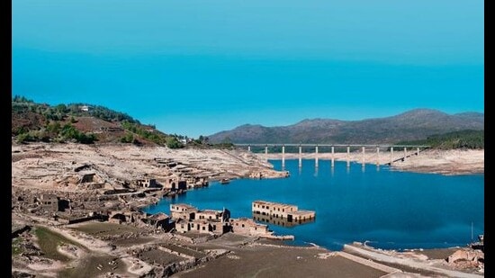
Elsewhere in Spain, other monuments have resurfaced as water levels plummet at reservoirs: At the Alto Lindoso reservoir, the eerie remains of an entire village, Aceredo, submerged in 1992. At the Buendia reservoir, the ruins of the La Isabela bathhouses, caked in mud. And at the Sau reservoir near Barcelona, the impressive 11th-century church of Sant Romà de Sau, submerged to create a reservoir in 1965, during the rule of the Spanish dictator General Franco.
.
Chongqing, China: A Buddhist past reveals itself
China is experiencing its most extreme heatwave in six decades. Low rainfall and high temperatures (many cities often hit at least 40 degrees Celsius this season) sparked blackouts, factory shutdowns and halted shipping on dwindling rivers.
The world’s third-largest river, the Yangtze, which provides drinking water to over 400 million people and is also China’s most important commercial waterway, is at record low levels. Rainfall along the river’s basin has been 45% lower than usual.
In the southern municipality of Chongqing, a previously submerged island reef called Foyeliang has reappeared. On its high point sit three Buddhist statues carved into a boulder, believed to be 600 years old, dating to the Ming and Qing dynasties. The largest is about 1 metre high and depicts a monk sitting on a lotus pedestal, flanked by two junior monks, presumably blessing boats as they pass by.
Further north on the Yangtze, at Sichuan, the pedestal of the largest stone Buddha in the world emerged in August. The 71m monument was carved into a cliff at the intersection of three tributaries during the Tang Dynasty (c. 803 CE). Its pedestal, which has been submerged since the floods of 2020, are now visible, with water levels now standing 2 metres below normal.
.
Rome, Italy: Bridge over troubled waters
Italy is in the midst of its worst drought in 70 years. Water levels in the Tiber river have dropped about 5 ft. And with lowered water levels, the foundation of the ancient Pons Neronianus or Bridge of Nero has emerged.
The bridge was likely built in the 1st century CE at the behest of Nero or his predecessor, and used by the emperor to access his family gardens. It is originally thought to have had four piers, two of which were removed in the 19th century to make way for river traffic.
The bridge was also likely used by victorious armies returning to Rome in grand parades, and to parade high-profile prisoners on their way to execution. It is believed to have fallen out of use by the 3rd century.
Where glimpses of the ancient foundation have been visible from time to time, an entire stretch now sits above water, near the Vittorio Emanuele II Bridge, within view of the fortress-turned-museum Castel Sant’Angelo.
Elsewhere in Italy, as its longest river, the Po, dries up, it has revealed the remains of an ancient hamlet in Piedmont, and the wreck of a 164-ft-long World War 2 barge, the Zibello. In the river Oglio, foundations of a timber structure dating to the Bronze Age have been found, and in Lake Como, 100,000-year-old remains of deer, hyenas, lions and rhinos.
.
Germany & France: Hunger stones offer warnings and hope
In central Europe, landmarks of the starkest kind: Famine memorials erected between the 15th and 19th centuries are resurfacing as river waters dwindle. They had shown up in 2018 as well, at the start of Europe’s last severe drought.
More than 25 such stones have been revealed so far, on the banks of the Rhine and Weser rivers in Germany, the Moselle in France, and the Elbe, which flows from the Czech Republic through Germany.
They were put there to mark levels during historic famines and warn future generations of the horrors to come if the rivers dropped that low again. “When you see me, weep”, the text on one proclaims.
It tells of a drought so severe that people died from starvation. The stones speak also of scarcities, high prices, widespread hunger. Some bear messages of hope: “When this stone goes under, life will become more colourful again.”
.
Yorkshire, England: The ghosts of hamlets
England has had the hottest summer on record this year, tied with 2018. Along with the heatwave came archaeological wonders hidden from view for centuries: ghost gardens, old bridges, submerged hamlets.
At the Baitings reservoir, as water levels reached historic lows, an 18th-century packhorse bridge emerged, dwarfed in size by a gleaming new crossover. It’s part of a route that once linked Yorkshire and Lancashire. The bridge and a hamlet were flooded in 1956, when the reservoir was built to supply water the city of Wakefield in West Yorkshire. At the Thruscross Reservoir, remnants of West End, a 17th-century village that went under in the ’60s has also emerged.
And at the Chatsworth Estate near Chesterfield, the ornamental patterns of a 17th-century landscaped garden surfaced, as the grass of the south lawn was scorched out of view.
One Subscription.
Get 360° coverage—from daily headlines
to 100 year archives.
Archives
HT App & Website