
 E-Paper



December off to a chilly start, Delhi’s min temperature plunges to 5.7°C
Officials said the polar vortex is expected to push temperatures further down in these regions.

 Prefer HTon Google


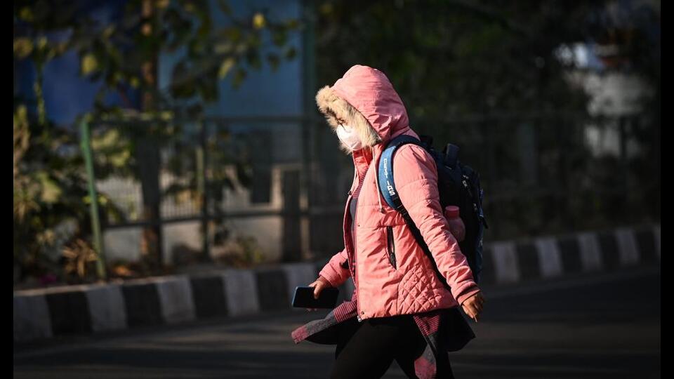
Delhi’s December started on a biting note on Monday as temperatures plunged to 5.7°C, five degrees below normal for this time of year. The India Meteorological Department (IMD) said the chill is expected to persist, with the possibility of coldwave conditions in isolated pockets of the Capital until at least December 5.
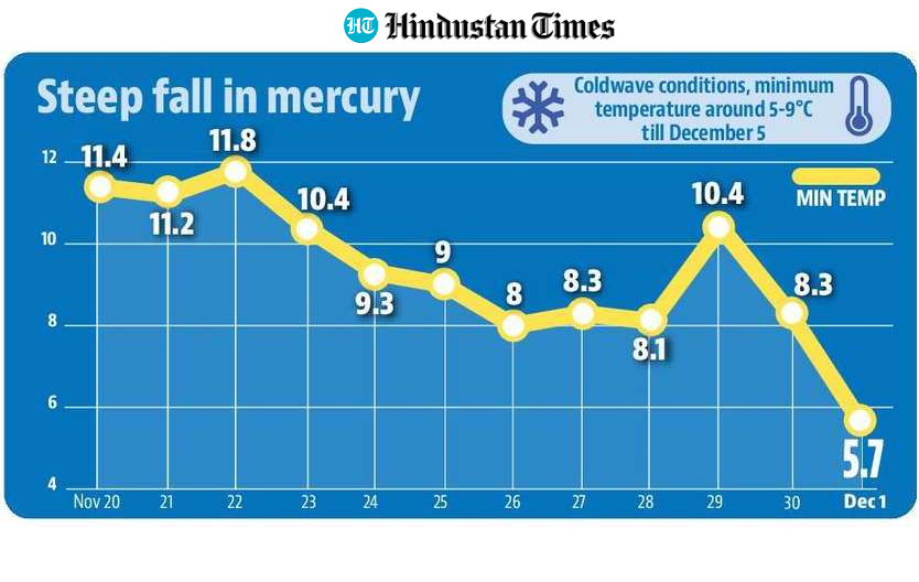
Monday’s minimum was not only the lowest so far this season but the lowest recorded in the first week of December in at least 14 years, according to IMD data since 2011.
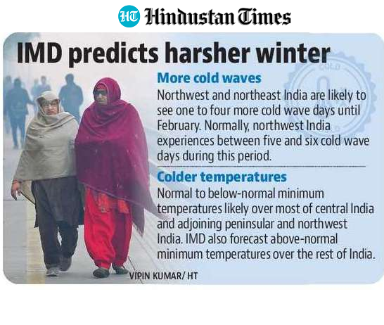
Forecasts suggest a colder-than-usual winter ahead, with higher-than-normal coldwave days likely across central India and parts of northwest and northeast India. Officials said the polar vortex is expected to push temperatures further down in these regions. Between December and February, IMD expects one to four more coldwave days in the region than usual. Northwest India typically sees five to six coldwave days during this period.
A coldwave is declared when the minimum temperature drops below 10°C and is also 4.5°C or more below normal, with at least two stations meeting this criterion for two consecutive days.
IMD did not issue a coldwave alert for Delh ion Monday, stating the threshold must also be met on Tuesday.
Krishna Mishra, IMD scientist, said that while temperatures fell below the threshold at more than two stations in the Haryana-Chandigarh-Delhi subdivision, it was the first day of such departures. A slight rise in minimum temperatures is expected on Tuesday, with citywide lows forecast to oscillate between 5°C and 9°C until December 5.
While Safdarjung, Delhi’s base weather station, recorded 5.7°C; Lodhi Road registered 5.8°C and Ayanagar 6.5°C. The temperature has dropped sharply over the past three days – from 10.4°C on Saturday to 8.3°C on Sunday, and further down on Monday.
Historical data shows Delhi rarely sees a coldwave in early December. In recent years, the earliest coldwave in the month was recorded on December 19, 2020.
Experts attributed the sudden dip to strong northwesterly winds following a western disturbance that moved across the Himalayas. “Cold, icy northwesterly winds have led to a drop in night temperatures across Punjab, Haryana, Delhi and Rajasthan. Multiple stations in Delhi reported single-digit lows, and temperatures fell below 5°C in parts of Punjab, Haryana and Rajasthan,” said Ashwary Tiwari of IndiaMetSky on X. He added that similar conditions are expected in the coming days.
December temperatures in Delhi typically only drop around 5°C in the latter half of the month.
Last year’s lowest minimum was 4.5°C, recorded on December 12 and 16. In 2023, it was 4.9°C on December 15. In 2022, temperatures dropped to 5°C on December 26; in 2021, to 3.2°C on December 20; in 2020, to 3.1°C on December 31; and in 2019, to 2.4°C on December 28.
The all-time lowest December minimum remains 0°C, recorded on December 27, 1930. Delhi last recorded a December coldwave in 2021, with four coldwave days. Since 2011, the highest number of December coldwave days – eight – occurred in 2018.
The sharp dip in temperature also worsened Delhi’s already strained air quality. The AQI slipped back into the ‘very poor’ category, with a 24-hour average of 304 at 4 pm on Monday, compared with 279 (‘poor’) the previous day. Forecasts from the Air Quality Early Warning System for Delhi indicate that the AQI is likely to remain ‘very poor’ until at least December 4.
Below-normal temp likely in India: IMD
Meanwhile, IMD projects normal to below-normal minimum temperatures in most parts of central India, along with adjoining peninsular and northwest regions. Above-normal minimum temperatures are expected in the remaining areas. During December, normal to below-normal daytime temperatures are likely across central India, northwest India and parts of peninsular India, while most other regions may experience above-normal maximums. Spatial temperature maps show that parts of Haryana, Rajasthan, Delhi and Gujarat are expected to record below-normal temperatures.
For rainfall, IMD expects normal precipitation nationally in December – 79% to 121% of the long-period average. Above-normal rainfall is likely over much of peninsular and west-central India, as well as pockets of east-central and northeast India. The rest of the country is likely to receive below-normal rainfall.
IMD officials said temperature patterns in November were already influenced by the polar vortex, which led to below-normal temperatures across northwest and central India. The polar vortex, combined with developing La Niña conditions, is expected to drive very cold weather over the next three months.
“Below-normal temperatures and coldwave conditions over Madhya Pradesh had something to do with the polar vortex and La Niña. Now again the polar vortex has started impacting,” said OP Sreejith, head of IMD’s Climate Monitoring and Prediction Group.
The polar vortex is a large area of low pressure and cold air circulating around the poles, strengthening in winter and weakening in summer.
IMD director general M Mohapatra said fewer western disturbances are expected over the winter, and La Niña will likely intensify the cold. “The forecast is based on a dynamical system. Not many western disturbances are expected, and La Niña will have an impact,” he added.



Stay updated with all top Cities including, Bengaluru, Delhi, Mumbai and more across India. Stay informed on the latest happenings in World News along with Delhi Election 2025 and Delhi Election Result 2025 Live, New Delhi Election Result Live, Kalkaji Election Result Live at Hindustan Times.


