Delhi and the national capital region (NCR) may witness rainfall along with thunderstorm, lightning or gusty winds (speed reaching 30-40 kmph) in the next two hours, the India Meteorological Department (IMD) said on Wednesday.
West, northwest, southwest, and southern parts of Delhi along with Gurugram, Manesar in the NCR regions are expected to get downpours over the next couple of hours. Rohtak, Charkhi Dadri, Mattanhail, Jhajjar, Loharu, Farukhnagar and Kosali - all in Haryana, are also very likely to witness showers.
Earlier in the day, the weather department said an east-west trough passing through Haryana had resulted in a low-pressure area and, under its influence, parts of Punjab, Haryana, Uttarakhand, western Uttar Pradesh, and eastern Rajasthan could witness scattered light rainfall. Parts of Delhi could also see thunderstorm-like activity on Wednesday, which will keep temperatures in check, the IMD said.
{{/usCountry}}Earlier in the day, the weather department said an east-west trough passing through Haryana had resulted in a low-pressure area and, under its influence, parts of Punjab, Haryana, Uttarakhand, western Uttar Pradesh, and eastern Rajasthan could witness scattered light rainfall. Parts of Delhi could also see thunderstorm-like activity on Wednesday, which will keep temperatures in check, the IMD said.
{{/usCountry}}A heatwave is unlikely in Delhi for at least a week, Mahesh Palawat, vice president (climate change and meteorology), with private weather forecasters Skymet, was quoted as saying by news agency PTI.
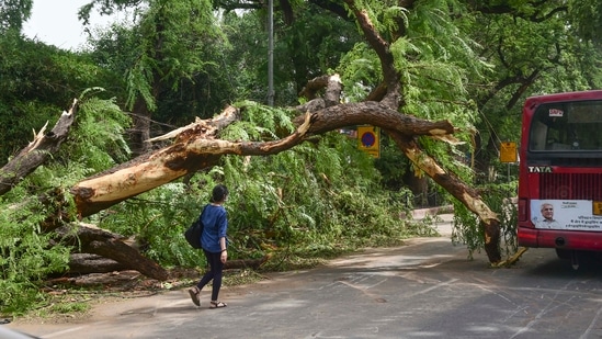
A powerful thunderstorm - packing winds of up to 100 km per hour - pummeled Delhi Monday, leaving two dead and over 530 trees uprooted, as well as flooding roads and creating traffic jams, causing widespread damage to property and vehicles, and disrupting internet and electricity supply.
READ: Violent storm, showers leave Delhi rattled
It was the first storm with wind speeds of over 100 km per hour since June 2018, when Cyclone Palam tore through Delhi with 104 km per hour winds.
The winds did, however, bring some respite from temperatures that earlier soared past 40 degrees Celsius after a squall (a week ago) dropped them below normal for most of the past few days.
Rains choke central Delhi for five hours | Delhi rain: At least 500 trees uprooted
There is a greater chance of sudden development of such powerful thunderstorms in May and June due to high temperatures and high humidity, the weather department has warned.
READ: Why did IMD fail to forecast the Delhi storm?
Such storms cannot be predicted a day or two in advance, an IMD official was quoted by PTI, after the agency was caught off-guard by the suddenness of Monday's downpour.
Initially the IMD only forecast 'thundery development' for Delhi on Monday. Alert levels were upgraded to 'yellow' at 3 pm on that day and then moved to 'orange' at 4.30pm.
By this time, though, it was too late for people and agencies to take precautionary measures.
High temperature and high humidity create thunderclouds capable of short, intense spells of rain and thunderstorms, Skymet's Palawat said.
(With inputs from PTI)
Stay updated with all top Cities including, Bengaluru, Delhi, Mumbai and more across India. Stay informed on the latest happenings in World News along with Delhi Election 2025 and Delhi Election Result 2025 Live, New Delhi Election Result Live, Kalkaji Election Result Live at Hindustan Times.
Stay updated with all top Cities including, Bengaluru, Delhi, Mumbai and more across India. Stay informed on the latest happenings in World News along with Delhi Election 2025 and Delhi Election Result 2025 Live, New Delhi Election Result Live, Kalkaji Election Result Live at Hindustan Times.