E-Paper



Violent storm, showers leave Delhi rattled
Though not initially forecast, Monday’s short, but intense, thunderstorm was largely attributed to a combination of a western disturbance prevailing across north Pakistan and an induced cyclonic circulation over northwest Rajasthan.

 Prefer HTon Google


A violent squall left a trail of damage across much of Delhi on Monday evening, uprooting over 500 trees, countless poles, damaging a host of vehicles, and killing at least two people, as wind speeds touched 100km/hour at the Safdarjung station, officials said.

The winds did, however, bring the city some respite from temperatures that earlier this week climbed past 40 degrees Celsius (°C), after another squall exactly a week ago pushed the mercury down below normal levels for most of the past few days.
Though not initially forecast, Monday’s short, but intense, thunderstorm was largely attributed to a combination of a western disturbance (WD) prevailing across north Pakistan and an induced cyclonic circulation over northwest Rajasthan, with the India Meteorological Department (IMD) forecasting parts of Delhi to receive very light rain on Tuesday too.
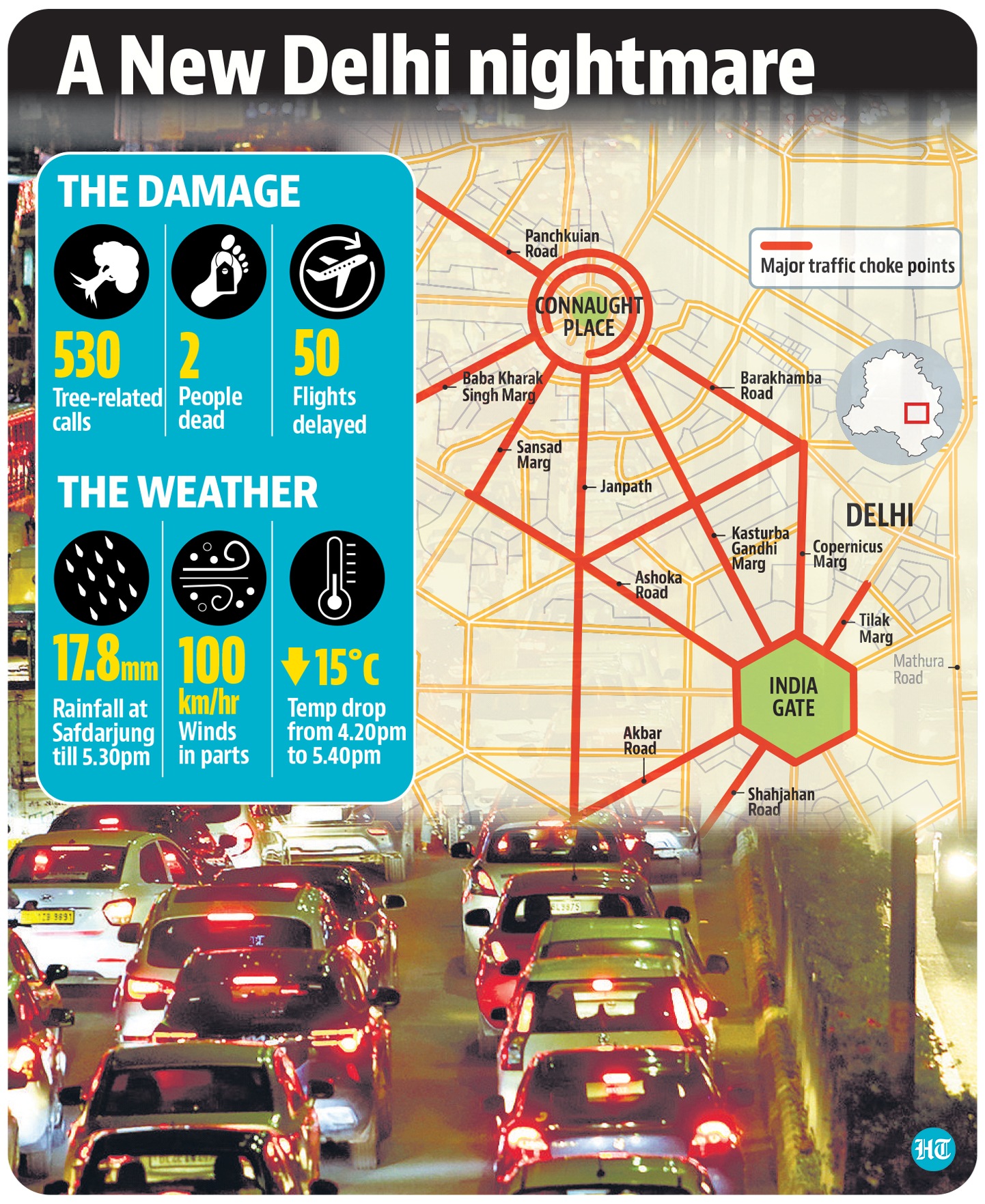
Safdarjung, Delhi’s base station for weather, recorded a maximum of 40.6 degrees Celsius (°C) on Monday, but mercury dropped by 15 degrees to 25°C between 4.20pm and 5.40pm, as IMD data showed the city received 17.8mm of rainfall till 5.30pm.
IMD scientist RK Jenamani said the major impact of the thunderstorm was seen over central and east Delhi, adding that a brief hail spell was also reported from Lodhi Road and around Lajpat Nagar between 4 and 4.30pm.
“The passing thunderclouds brought intense showers in a very small time, during which wind speeds were reportedly touching a speed of 100 km/hr at Safdarjung. It touched a speed of around 70 km/hr at Palam. The influence of this western disturbance, which is bringing moisture-laden easterly winds towards Delhi, could also bring isolated drizzle to Delhi on Tuesday,” he said.
He pointed out that such high wind speed is rare and was last seen only in 2018. “During squall spells, we have seen wind speeds of 70-80km/hr over the last few years, but the last time it touched 100km/hr was only in 2018 and that shows the intensity of this thunderstorm,” he said, adding that Delhi had both high temperature and high moisture during the day, with the WD acting as the trigger for the storm.
Parts of Delhi received light rain on Sunday night and in the early hours of Monday morning too, with Palam receiving ‘trace’ rainfall till 8.30am on Monday, Ridge receiving 4.2mm of rainfall and Ayanagar 3.2mm.
Following the thunderstorm spell, Safdarjung received 17.8mm of rainfall between 8.30am and 5.30pm, 20mm at Lodhi Road, 15mm in Ridge and 3.8mm in Ayanagar. “This spell largely occurred between 4pm and 5pm and brought intense rain in a brief 20 to 30 minute window. These are generally characteristic of pre-monsoon showers, which can lead to short but intense bursts of rain,” Jenamani added.
Delhi has now received 47.7mm of rainfall so far this month at Safdarjung, more than twice the normal monthly average of 19.7mm. In comparison, both March and April were substantially dry, with March receiving zero rainfall and April only 0.3mm.
Lieutenant governor Vinai Kumar Saxena visited parts of Delhi to assess the damage and instructed officials to take immediate steps to clear these roads.
“Distressed by the sight of uprooted trees, fallen branches and water logging at places after the early evening storm. Visited few places. Instructed officials to take immediate steps to remove debris and clear the roads immediately so as to mitigate the inconvenience to people (sic).” he tweeted.
Flight operations hit
At least eight flights were diverted to nearby airports after strong winds and rain made it unable to land at the Delhi airport, airport officials said on Monday. The flights were diverted between 4pm and 6pm, and officials said 50 flights also faced slight delays.
The flights were diverted to nearby airports which included Jaipur, Lucknow, Chandigarh, Ahmedabad and Dehradun. According to the IMD, wind speeds touched a high of 70km/hr during between 4 and 4.30 pm, which make it difficult for aircrafts to land.
“Around eight flights were diverted to nearby airports on account of bad weather in Delhi. This was largely due to strong winds. Some flights also faced delays, with airport operations becoming normal after 6pm,” said an airport official.
Meanwhile, both Najafgarh and Jafarpur were Delhi’s hottest locations, recording a maximum of 42.8°C, before the thunderstorm hit Delhi.
IMD forecasts show Delhi could see very light rain and thundershowers towards Tuesday evening or night, with the temperature between 25°C and around 40°C. Humidity levels will also remain high.
Dry westerly winds will blow towards Delhi again from Wednesday, and the maximum temperature is expected to rise to around 41-42°C by Friday, officials said.