
 E-Paper


IMD forecasts more intense rains, Delhi headed for wettest monsoon in a decade
Compared to the normal monsoon rain 552.6mm, Delhi has already had a 79% surplus -- 988.4mm rain so far, shows IMD data. Monsoon in Delhi is officially considered between June 1 and September 30. It has also exceeded the monsoon season’s average rainfall of 648.9mm.
With India Meteorological Department (IMD) forecasting another intense rain spell over Delhi and adjoining areas between September 6 and 10, this could be one of the wettest monsoons for the city in at least over the past decade, IMD scientists and weather experts said.
")
Compared to the normal monsoon rain 552.6mm, Delhi has already had a 79% surplus -- 988.4mm rain so far, shows IMD data. Monsoon in Delhi is officially considered between June 1 and September 30. It has also exceeded the monsoon season’s average rainfall of 648.9mm.
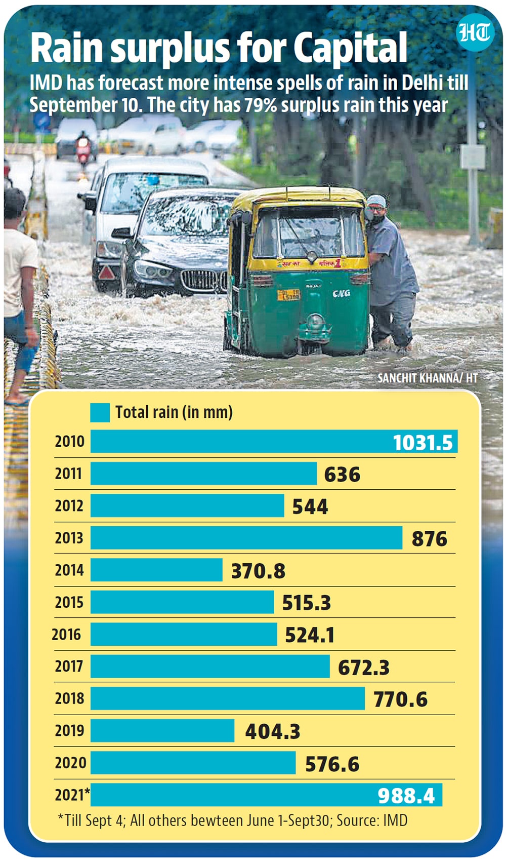
“This is already the highest rainfall received so far during the season since 2010 when 1031.5mm rainfall was received. Now, with another week of rain forecast, it may even surpass the 2010 mark. From September 6-10, another moderate to heavy spell of rainfall is likely over the northern plains including Delhi-NCR,” said a senior IMD official who asked not to be named.
As per IMD rainfall data, till Saturday, the city gauged 232mm rain whereas the normal September rainfall count is 125.1mm. Between August 31 and September 2, Delhi received 230 mm rain. With 112.1mm 24-hour rainfall on September 1, Delhi received the highest single-day rainfall for the month in the past 19 years, IMD said. On August 21, Delhi received 138.8mm rainfall in 24 hours, the highest for that month in over 14 years.
“These intense rain spells over the past week, and during the past month, have led to surplus rain. The most recent heavy spell was a result of a deep convergence line forming from Gujarat to Delhi along with the monsoon trough being in the normal position. Another low pressure system is forming over the Bay of Bengal, which will gradually travel to the northwest region from September 6-10, and may result in heavy rain during this time,” said R K Jenamani, senior IMD scientist.
This monsoon has been a season of extremes for Delhi. First, the monsoon was delayed by 16 days and finally hit the city on July 13. IMD data shows that till July 16, Delhi had a rainfall deficit of 46%. However, this was soon over with several heavy spells of rain in July as it ended in a monthly rainfall surplus of 141%. In July, Delhi received 507.1 mm rainfall, compared to the normal 210.6 mm. Then August had two dry spells, one of which lasted for 10 days. Rainfall in August oscillated from a monthly rain deficit of 60% to a surplus of 11%, and then ending with a deficit of 13%. August received 214.5mm rainfall against the normal monthly rainfall of 247.7 mm.
Independent weather experts said monsoon has behaved odd this season. From dry spells to intense rain, it has been oscillating from one extreme to another, and may result in the city having one of the wettest monsoons in many years. “The dry spells were mainly because both the frequency and intensity of low-pressure systems that form over the Bay of Bengal, which bring rainfall to different parts of the country, were too low. The systems that formed in between brought the heavy spells. September, however, is going to be good in terms of more spells of rain not just in Delhi, but the whole of northern plains and central India,” said Mahesh Palawat, vice-president, Skymet, a private forecaster.
Explaining the reasons behind this, he said, the frequency of formation of low-pressure systems has increased over the past fortnight. “With more systems forming and travelling over the northern plains, more rain is expected. Rain activity is likely to get intense from September 7-10. Then mid-September, another system is likely to form bringing in more showers. Last year, September was largely dry receiving only 20.9mm monthly rainfall,” said Palawat.

Stay updated with all top Cities including, Bengaluru, Delhi, Mumbai and more across India. Stay informed on the latest happenings in World News along with Delhi Election 2025 and Delhi Election Result 2025 Live, New Delhi Election Result Live, Kalkaji Election Result Live at Hindustan Times.