
 E-Paper



'Shot of smoke for Delhi': Nasa photo shows how farm fires added to pollution
Delhi's air quality continues to remain in the 'very poor' category for the sixth consecutive day on Friday, according to the System of Air Quality & Weather Forecasting & Research.

 Prefer HTon Google


American space agency Nasa has shared images of farm fires, which have led to spike in the levels of air pollution in Delhi. The image depicts hotpots with small red dots. The entire area around the national capital is seen with high levels of air pollution.
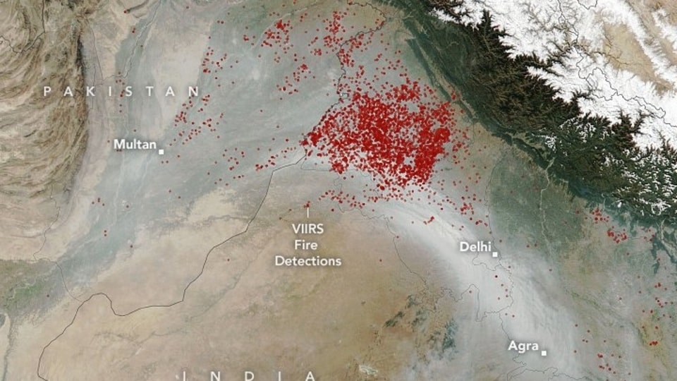
The images were taken by Visible Infrared Imaging Radiometer Suite (VIIRS) on the Suomi NPP satellite on November 11, Nasa informed on its blog.
“Looking at the size of the plume on November 11 and the population density in this area, I would say that a conservative estimate is that at least 22 million people were affected by smoke on this one day,” said Pawan Gupta, a Universities Space Research Association (USRA) scientist at Nasa's Marshall Space Flight Centre.
It further said that fires in northern Pakistan could also have contributed some of the smoke.
Delhi's air quality continues to remain in the 'very poor' category for the sixth consecutive day on Friday, according to the System of Air Quality & Weather Forecasting & Research (SAFAR).
However, the overall Air Quality Index reduced from 362 on Thursday to 332 today.
According to the SAFAR bulletin, Delhi's AQI will remain the same for the next two days.
An AQI between zero and 50 is considered 'good', 51 and 100 'satisfactory', 101 and 200 'moderate', 201 and 300 'poor', 301 and 400 'very poor', and 401 and 500 'severe'.
The entry of trucks in Delhi except those carrying essential commodities has been stopped till November 21.


