
 E-Paper



Why Aravalli range is the Capital’s lifeline
One, the range adjoins Delhi and the National Capital Region and acts as a natural barrier between it and the Thar to the West, preventing the relentless march of the desert, a process termed desertification.

 Prefer HTon Google


For years, Haryana governments of various hues had been focused on ensuring that the Aravallis were not declared as forests, but on July 21, the Supreme Court scotched those efforts. In its judgment on the implications of the Punjab Land Preservation Act 1900, the top court said that all land covered by special orders under section 4 of the law should be treated as forests, and that the provisions of the Forest Conservation Act 1980 would apply to these.
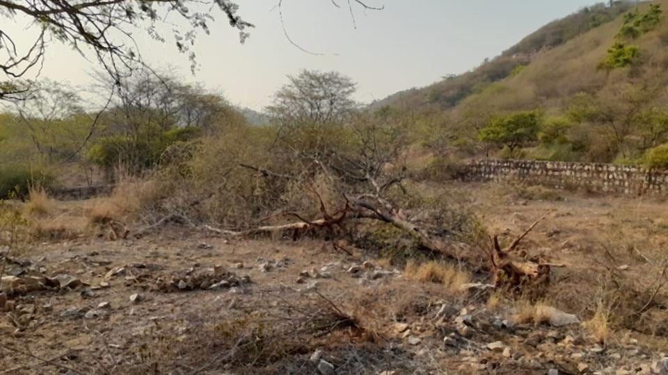
Around 31,738 hectares in Haryana are covered under special orders issued under section 4 and 5 of PLPA. The judgement implies that these will fall under the ambit of Forest Conservation Act 1980 and that the state or any other authority cannot permit its use for non-forest activities without the prior approval of the Centre.
It is surprising that a court judgement was required to protect a range whose environmental benefits are evident.
One, the range adjoins Delhi and the National Capital Region and acts as a natural barrier between it and the Thar to the West, preventing the relentless march of the desert, a process termed desertification. Indeed, dust from the desert is one reason for Delhi’s perennial bad air.
Two, the Aravallis are a massive and effective groundwater recharging zone in an area that’s otherwise dry.
Three, they are a biodiversity hotspot.
Many experts believe the integrity of the Aravallis is intrinsic to the well-being of around 64 million people in the NCR, a region where a lot of politics and business has always revolved around land – presenting a paradox.
The significance
The significance of the Aravallis in Haryana (which stretch from Gujarat and Rajasthan to Delhi and Haryana), one of the oldest fold mountain ranges in the world, is captured in a 2017 Wildlife Institute of India report titled “Mapping land use/land cover Patterns in Aravallis Haryana with Reference to Status of Key Wildlife Species”. It is a report that makes for depressing reading, and concludes that the forests of the range are now the most degraded forests of India.
“The rapid deforestation and developmental activities are destroying the unique landscape that requires immediate conservation attention. These vulnerable areas are biologically rich and support several unique elements of flora and fauna. Hence proper assessment and monitoring is necessary for restoration of the biological diversity because lack of ecological information leads to mismanagement.”
Surveys by the WII team in parts of Gurugram, Faridabad, Mewat, Mahendargarh and Rewari revealed the presence of 10 mammalian species--common leopard, striped hyena, golden jackal, grey wolf, indian fox, jungle cat, grey mongoose, small Indian civet, Indian crested porcupine, Indian hare, wild pig, rhesus macaque, blue-bull (Nilgai) and Indian gazelle (Chinkara). It showed forest cover in the Haryana Aravallis was very low (It is only 3.63% of the total geographical area as per State of Forest Report 2021) and only exists in the form of two categories i.e open (sparse canopied forests) and scrub forests.
The conservation of these patches must be prioritized, the authors said. “All priority areas identified in this report should be considered for long-term conservation and management. Site level conservation and management plans should be prepared in consultation with local stakeholders to make conservation effective in these remaining forest patches of Aravallis in the state of Haryana.” The most serious threat to wildlife and forests is developmental activities, which are gradually destroying the remnants of Aravallis left in the five districts of Gurgaon, Faridabad, Mahendragarh, Mewat and Rewari, the report stated.
The WII study flagged that due to excessive run off and soil erosion, the Aravallis are progressing towards becoming barren mountains devoid of vegetation. These recently generated ecological hazards will eventually increase desertification in Aravallis and lead to progress of desertification towards Delhi. “The denudation of forests along the northern and central Aravalli tracts is causing the advancement of the desert particularly in the gap areas with increasing intensity of dust storms. Furthermore, the excessive deforestation has intensified the process of soil erosion, causing siltation in the river channels and water reservoirs.
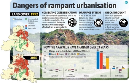
The interpretation of remotely sensed data products of 1972-75, 1982-84, 1994-96 and 2005-07 has revealed that the desert sand is drifting towards north-eastern plains through twelve identified gaps on the Aravalli hills extending from Magra hills in Ajmer district to Khetri-Madhogarh hills in Jhunjhunu and northern most hillocks in Mahendragarh district of Haryana,” the report said.
Land degradation or desertification in Haryana has increased from 7.67% in 2011-12 to 8.24% in 2018-19 according to the Desertification and Land Degradation Atlas of India released by the Space Application Centre of Indian Space Research Organisation (ISRO) in 2021. But in adjoining Delhi, 61.73% of the total geographical area is undergoing desertification. The area undergoing desertification during 2011-13 and 2003-05 was 60.60% and 49.57% respectively.
Haryana’s forest cover, according to Forest Survey of India, is only 3.63% of its geographical area, down from 3.53% in 2009 and 3.59% in 2005. “Forests in the Haryana Aravallis create a moisture regime that helps settle dust and sand particles that are blowing in from the northwest. It acts as a barrier and nutrient to the soil. If you lose this vegetative barrier then plants in the region will lose resilience as dust will affect their survival. The Aravallis also create a microclimate that edges out desertification or dry soil and air,” explained Vijay Dhasmana, ecologist and curator of the Aravalli Biodiversity Park in Gurugram.
“These forests are home to a lot of wildlife and birdlife. Hyenas, leopards, porcupines, jackals are species that exist in good numbers. There are also over 300 species of birds here. Prosopis juliflora dominates these forests but in pockets particularly areas like the Mangar Bani, Jhiri etc you see local tree and plant species. For example, on the Gurugram-Faridabad Road you can see pockets of Dhok. These forests are integral to controlling flash floods, desertification, reduce run-off and recharge groundwater for entire NCR. They are the last patch of forests left for the region that can provide these ecological services without which functioning of cities in NCR can be jeopardised,” added Dhasmana, one of the country’s top experts in rewilding.
What is at stake
Bilal Habib, scientist with the Wildlife Institute of India said that the Aravallis are among the oldest mountain ranges in the world, and areas such as the Delhi ridge are remnants from the range. “Do we need any more reason to save the Aravallis? Aravallis have acted as a barrier to desertification in the region, losing them can be disastrous for people of the region.”
“The Aravallis of Delhi NCR act like a buffer against the worst impacts of heat islands, air and noise pollution. The forests regulate the micro-climate, and there is a noticeable difference between the ridge and the Aravalli forests and other areas of the metropolis – the Aravallis are cooler and moist. The Aravallis also perform as an ecological corridor. Currently, threatened species like leopards are in Asola wildlife sanctuary have come through functional ecological corridors. The forests are biodiverse and important destinations for forest migrants. The Indian Pitta comes to the Aravallis from Central or Southern India to breed. Several migratory birds like flycatchers and warblers also come here and saving this place means fulfilling our commitments for migratory species,” added Neha Sinha, conservation biologist and author.
Indeed, the Aravallis lie along the Central Asian Flyway and are a birding hotspot. And their continued degradation had made Delhi what it is.
The Indian capital is the most polluted city globally among over 7,000 cities with annual average PM2.5 (fine, respirable pollution particles) exposure level of 110 micrograms per cubic metres according to The State of Global Air 2022, a report by US based Health Effects Institute released in August. It’s only natural to expect that Delhi’s air quality will worsen further if the large green lung in adjoining Haryana were degraded and converted for constructions.
The Supreme Court in its order on prohibiting mining in the Haryana Aravallis dated March 18 in MC Mehta vs Union of India and Others described the importance of Aravallis in detail. “The Aravallis, most distinctive and ancient mountain chain of peninsular India, mark the site of one of the oldest geological formations in the world. Heavily eroded and with exposed outcrops of the slate rock and granite, it has summits reaching 4950 feet above sea level. Due to its geological location, the Aravalli range harbours a mix of Saharan, Ethiopian, Peninsular, oriental and even Malayan elements of flora and fauna. In the early part of this century, the Aravallis were well wooded. There were dense forests with waterfalls and one could encounter a large number of wild animals. Today, the changes in the environment at Aravalli are severe. Though one finds a number of tree species in the hills, timber quality trees have almost disappeared. Despite the increase of population resulting in increase of demand from the forest, it cannot be questioned nor has been questioned that to save the ecology of the Aravalli mountain, the laws have to be strictly implemented.”
Restoration key
Sinha said that in order to increase Delhi’s climate resilience, the protection and the restoration Aravallis is key. “This is likely to increase groundwater, and help in adaptation against extreme heat. Native Aravalli plant species are heat-adapted and the area requires protection from random plantation of exotics or invasives. The area also suffers from illegal mining. Lakes in Aravallis like Surajkund and Damdama are doing very badly. This needs remedial action.”
According to the Central Ground Water Board (CGWB) in 2018, the depth to water level continues to be high between 0 to 10 metres below ground level (bgl) in Faridabad, Mewat, Palwal adjoining Delhi compared to Gurugram, Mahendargarh, Rewari etc which have a very low groundwater table indicating continued exploitation of the aquifers. Their depth to water level is 10 to 40 metres bgl. “This means the groundwater table is high in Aravallis and not so high in neighbouring areas. Aravallis are a reservoir of fresh water for entire NCR. The hills are elevated and hence the water runs down and infiltrates the ground,” said Shashank Shekhar, Delhi University assistant professor of geology.
In a 2008 affidavit filed by the Union environment ministry in MC Mehta vs Union of India, MoEFCC referred to a CGWB report on the ground water recharge potential in the Gurugram, Faridabad and Delhi stretch of Aravallis. “Groundwater outflows from this area towards all directions. This area primarily forms recharge zones for downstream areas in most directions…. This central part forms a groundwater mound…the hard rock formations comprising hills form recharge zones for downstream areas. Infrastructural activity in hilly area should be kept in check.”
“The Aravallis have extensive cracks and fissures which lead to high levels of groundwater recharge. Even if we assume groundwater recharge at a low level of 33.3% of average annual rainfall of 600mm per year, a quick back-of-the-envelope calculation shows that it amounts to 20 lakh litres per hectare per year. If this is valued at 10 paise per litre, it is worth ₹2 lakhs per year,” said Chetan Agarwal, Gurugram based forest analyst. “Aravallis serve as groundwater reservoirs and transmit it in all directions, providing an infusion of groundwater to surrounding plains areas.



