
 E-Paper



18 Mumbai suburban railway stations get digital maps
The maps are placed near the entrance of the stations and have details of passenger amenities including foot overbridges, washroom, platforms, water vending machines, food stalls, booking offices, ATM machine placements, railway offices, lifts and escalators at the station.


In a bid to improve accessibility of passengers travelling by local trains on the suburban railway network, Central Railway (CR) has equipped 18 railway stations with digital maps.
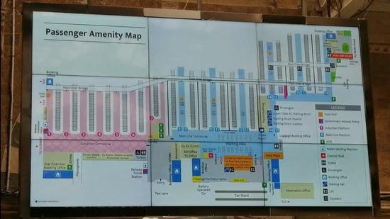
The maps are placed near the entrance of the stations and have details of passenger amenities including foot overbridges, washroom, platforms, water vending machines, food stalls, booking offices, ATM machine placements, railway offices, lifts and escalators at the station.
The maps are placed at Chhatrapati Shivaji Maharaj Terminus (CSMT), Dadar, Lokmanya Tilak Terminus (LTT), Kurla, Ghatkopar, Thane, Kalyan, Masjid Bunder, Panvel, Byculla, Matunga, Sandhurst Road, Sion, Vikhroli, Bhandup, Mulund, Dombivli and Mankhurd railway stations.
“Digital display map has the potential to revolutionise the way Indian Railways is perceived, by facilitating travel by providing each passenger with timely information which is relevant, visible, language neutral and dynamically changeable,” said Shivaji Sutar, chief public relations officer, Central Railway.
The maps will also help the zonal railway to increase their non-fare revenue. Earlier, the zonal railway had placed large signboards at CSMT station displaying platforms of suburban and mainline passenger amenities.
Stay updated with all the Breaking News and Latest News from Mumbai. Click here for comprehensive coverage of top Cities including Bengaluru, Delhi, Hyderabad, and more across India along with Stay informed on the latest happenings in World News.


