
 E-Paper



Bengaluru encroachments: What really made them possible?
The question how did the encroachments happen takes us to the root cause of the problem - the land transaction process.


The Bengaluru municipal corporation’s ongoing demolition drive against properties built on stormwater drains in the city to prevent flooding during rains has raised more questions than answers.
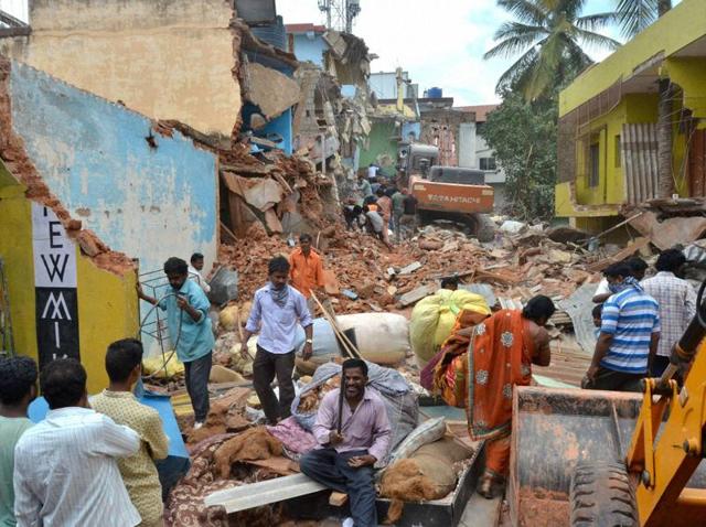
That individual owners and real estate players could easily encroach upon government properties in the IT city over the last few decades has been made evident by the drive.
The question how did the encroachments happen takes us to the root cause of the problem - the land transaction process.
An officer from the Karnataka revenue department says during the land registration, the registering authority does not insist for field verification, but only asks for land survey records.
“The registration act, which is a central act, does not demand any field verification before registration and relies only on the documents produced during the registration. Till 1999, for instance, if a landowner had 10 acres of land and if he divided it into 10 parcels (1 acre each), the registration authority allowed him to sell it to any number of persons, which could be more than the total number of parcels. There is no mechanism or provision in the act that prevents him from registration,” he explains.
In a nutshell, the flaws in the registration law have allowed the encroachment problem to thrive, instead of preventing it. Add to this the fact that the survey, settlement and land records department of the Karnataka government has failed abjectly to conduct periodic land surveys, thus contributing to the muddle in equal measure.
The Karnataka land revenue act mandates the department to carry out survey and settlement process of fixing land boundaries once in 30 years. But then, in Bengaluru the last land re-survey was done in 1965. The survey then too was not a comprehensive one, for it was done on the basis of the prior survey in the early 20th century.
A senior officer from the survey department said on the condition of anonymity that an elaborate land survey was done in Karnataka from 1902 to 1920, during the British regime. Post-Independence, the state government did a resurvey of the land across the state from 1958 to 1965, keeping the older survey map as the base.
Read Part I | Why some home-owners in Bengaluru suddenly had no roof over their heads
Though another city survey of the core Bengaluru was carried out in 1975, it was not done in other parts which were added to the city as the IT hub witnessed rapid growth. In 2007, seven city municipal councils, one town municipal councils and 11 villages were added to the Bangalore City Corporation.
“The encroachments that we see now have all taken place after 1965,” the officer notes.
Because of a lack of political will and administrative power, a fresh and comprehensive land survey and settlement was not done in a century. Initiating a land survey inevitably implies more problems.
“Though the land survey is meant to solve problems, it will naturally generate new problems. We are at a time when people fight for every inch of land. People just won’t accept our survey and get into a dispute claiming that the survey is full of flaws. The survey department’s attempts to resurvey the land in smaller towns in the past faced stiff opposition from the public and our attempts went futile,” the officer from the survey department says.
If that is one reason behind the department’s lethargy, the survey method adopted too adds up to the problem.
The method followed in the early and mid 20th century was way different from the one being followed now. Earlier, boundaries between two properties were demarcated through bunds, the width of which used to be up to 6-8 feet. But now, a piece of land is measured in centimetres and millimetres and the accuracy level is naturally higher.
“People will not buy this difference in measurement and the survey process becomes tougher,” the officer says.
He admits the revenue department’s failure to perform its statutory obligations and says things would have been different if the surveys were conducted regularly.
“As urbanisation began, we should have initiated the process of city survey. It should have been a continuous process. If at all we had done the timely surveys, encroachments in Bengaluru would have been avoided or at least cleared from time to time,” he says.
Perhaps the angriest voices in the aftermath of the demolitions have been against the urban local bodies or the municipality. Why were these authorities silent when layouts were sanctioned and property transactions endorsed?
The concluding article in this three-part series will attempt to answer that.
This story has been published through an arrangement with Oorvani Foundation/Open Media Initiative.


