
 E-Paper



How older landslide led to Wayanad tragedy: ISRO shows in before-after satellite images
Images taken from satellite before Wayanad landslide by Cartosat 3 on May 22, 2023, and after the event by VHR RISAT SAR on July 31, showed scale of the damage.


The Indian Space Research Organisation (ISRO) has released images showing the severe landslides in Kerala's Wayanad district that have resulted in at least 201 deaths and around 300 missing, as per the state government's latest updates.
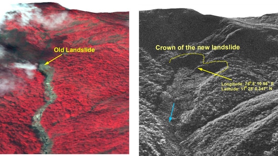
The high-resolution images from ISRO's National Remote Sensing Center reveal that heavy rainfall triggered a major debris flow around Chooralmala town.
The landslide started from an area affected by an older landslide. “The crown zone is an area activated from an older landslide,” NRSC said.
The flow widened the Iruvanipuzha river, causing it to breach its banks and damage surrounding homes and infrastructure.
Images taken before the landslide by Cartosat 3 on May 22, 2023, and after the event by VHR RISAT SAR on July 31, showed the scale of the damage. The 3D model of the landslide’s crown showed that a large portion of the hill slope was impacted. The landslide covers an area of 86,000 square metres, stretching approximately 8 km.
As of the latest updates, 195 people have been confirmed dead, and over 200 are missing.
ALSO READ- Wayanad landslides: Kerala govt slammed for gag order for scientists; CM Vijayan withdraws it later
Three possible reasons behind Wayanad landslides
Climate change, fragile terrain and loss of forest cover created the perfect recipe for the devastating landslides in Kerala's Wayanad.
High vulnerability in Western Ghats
According to ISRO's National Remote Sensing Centre's landslide atlas, 10 out of the 30 most landslide-prone districts in India are in Kerala, with Wayanad ranking 13th.
The Western Ghats and Konkan hills (Tamil Nadu, Kerala, Karnataka, Goa, and Maharashtra) cover 0.09 million square kilometers prone to landslides.
The high population and household density in Kerala's Western Ghats increase the vulnerability of its inhabitants.
Deforestation and plantation expansion
A 2021 study highlighted that all landslide hotspots in Kerala are in the Western Ghats, particularly in Idukki, Ernakulam, Kottayam, Wayanad, Kozhikode, and Malappuram districts.
About 59 per cent of landslides in Kerala occurred in plantation areas. Another 2022 study revealed that Wayanad's forest cover decreased by 62 per cent between 1950 and 2018, while plantation areas increased by 1,800 per cent. Initially, 85 per cent of Wayanad was under forest cover until the 1950s.
ALSO READ- Pinarayi Vijayan on Wayanad landslides: 'Nobody left to be saved'
Climate change impact
S Abhilash from Cochin University of Science and Technology said that the warming Arabian Sea leads to the formation of deep cloud systems, causing heavy rainfall in Kerala.
This atmospheric instability is linked to climate change, previously common in the northern Konkan belt but now affecting regions like Kerala.


