E-Paper



Months before Chamoli tragedy, satellite images showed crack in mountain ice
Scientists from Dehradun’s Wadia Institute of Himalayan Geology, who visited the disaster scene, have come up with similar findings, minus the crack being visible months before


Months before the landslide, which triggered flash floods in Uttarakhand’s Chamoli on February 7, satellite images showed a crack opening on an ice-covered flank of 6,029 metre-high Ronti mountain, American space agency NASA’s Earth Observatory has said in a report. The report published on the observatory’s website added this became clear after comparing high-resolution satellite images of the area before and after the tragedy on January 20 and February 21. It cited a closeup of the images in the same area before and after the debris flow and pointed to a “dark scar near the origin of the landslide and the trail of dust and debris that blanketed the valley walls downstream”.
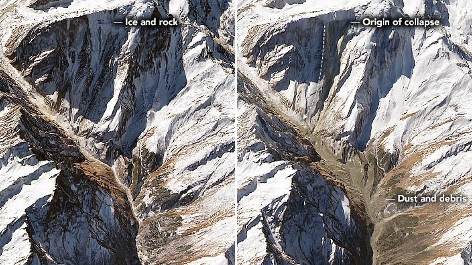
“On February 7, 2021, a huge chunk of a steep slope broke off from the peak, bringing down part of a hanging glacier perched on the ridge. After freefalling for roughly two kilometres, the rock and ice shattered as it slammed into the ground, producing an enormous landslide and dust cloud.”
Also Read | NASA releases panorama taken by Mars rover
The report added as the accelerating rock and ice raced through the Ronti and Rishiganga River valley, they picked up glacial sediments and melted snow. “All the materials mixed into a fast-moving slurry that overwhelmed the river and churned wildly as it rushed through the river valley.”
The observatory shares images, stories, and discoveries about the environment, and climate that emerge from NASA research.
Scientists from Dehradun’s Wadia Institute of Himalayan Geology, who visited the disaster scene, have come up with similar findings, minus the crack being visible months before.
Kalachand Sain, the institute’s director, said experts were scanning satellite imagery of Ronti mountain to establish when the crack or movement became visible. He added they overall know what happened, but more study was needed for the specific details and the sequence of events.
“Our team, after studying the site and comparing the ground observations with satellite imagery, found that crashing of the hanging rock mass/snow down the mountainside, took debris, rocks, snow with it, which led to the tragedy downstream the Rishiganga.”
Sain said due to freezing, thawing, and temperature variation, the rock mass loosened and broke off due to the gravitational pull. He added it slid down with snow, debris, and boulders, and soil.
Sain said the mass got into the Ronti Gad stream, which receives waters from glaciers in the area. “The mass blocked the water of the stream damming it up to such an extent that it breached and the whole mass of water, boulders, and rock...” He said the mass came crashing down with force towards the Rishiganga Dam site and left 69 people dead and 135 missing.
Sain said even now there is some remnant debris in the stream. He added if rains lash the area or snow melts, it could again lead to water accumulation. “We, as well as authorities, are keeping a tab on all these developments so that timely measures can be taken.”