E-Paper



China’s PLA scaling up in Aksai Chin: Satellite data
In light of Beijing's unveiling of the 2023 “standard map of China,” portraying Aksai Chin and Arunachal Pradesh as its territory, this development has emerged.

 Prefer HTon Google


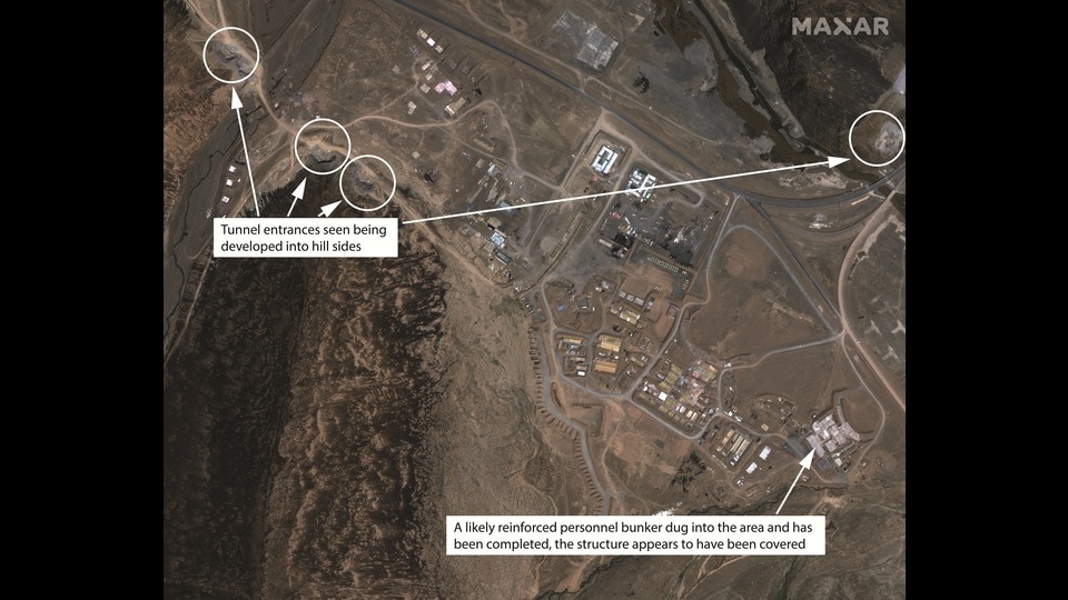
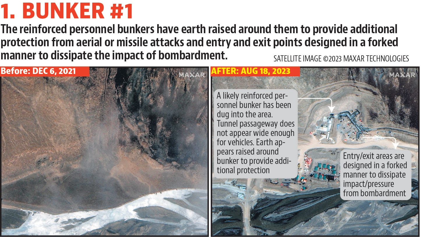
An analysis of satellite imagery from Aksai Chin, a region that India has for long accused China of occupying illegally, shows the Chinese side has ramped up the construction of reinforced bunkers and underground facilities to better protect military assets from aerial or missile strikes.
The development comes at a time when Beijing has released the 2023 edition of its so-called “standard map of China” depicting Aksai Chin and Arunachal Pradesh as part of the country’s territory. The map was issued by China’s natural resources ministry on Monday as part of the annual “National Surveying and Mapping Promotion Day”.
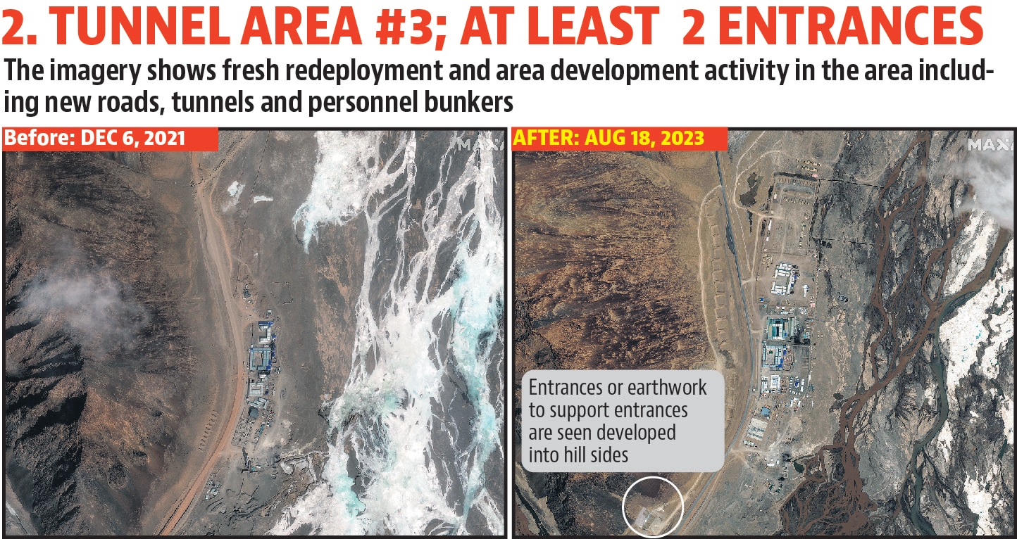
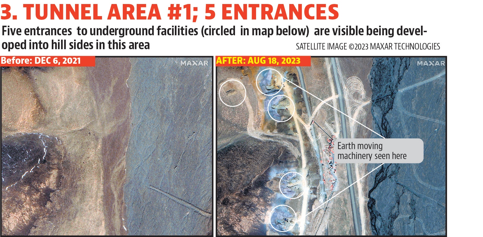
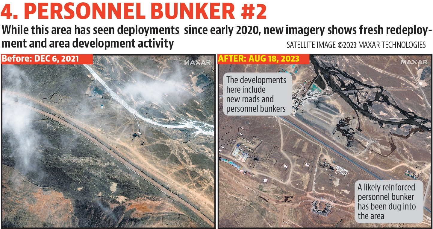
A comparison of satellite images from December 2021 and August this year – provided to Hindustan Times by Maxar Technologies – shows the Chinese side has built reinforced bunkers and underground facilities at six locations within an area of roughly 15 sq km in Aksai Chin.
This area is located about 70km from the Line of Actual Control (LAC) and while troops were deployed in the region following the start of the standoff in May 2020, most of the land was barren and with few signs of construction activity, apart from some overground facilities to host equipment.
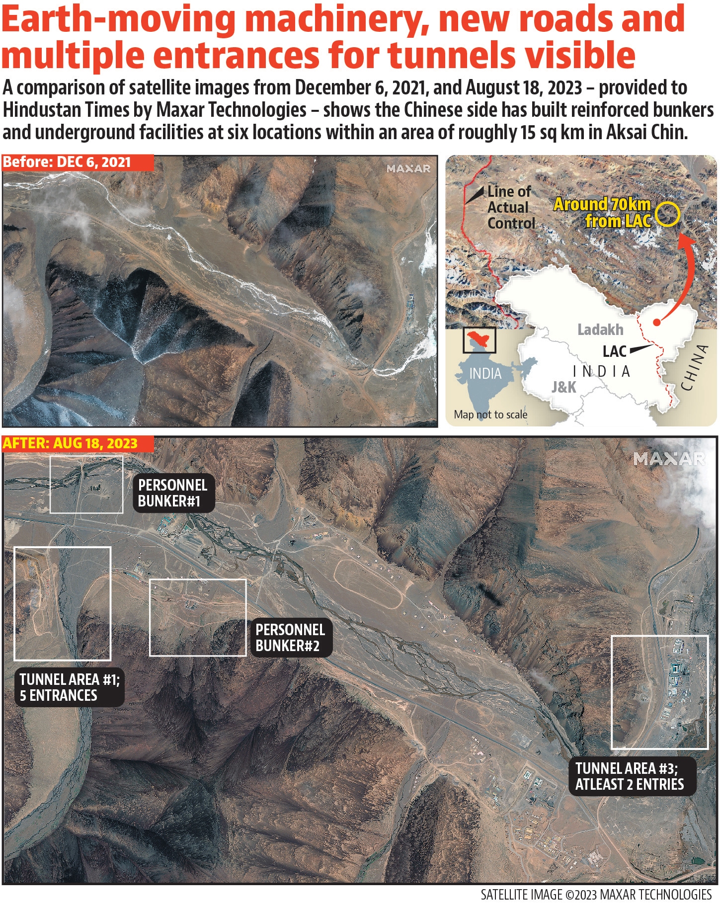
However, the latest images from August 2023 show considerable construction activity, including the presence of earth-moving machinery, new roads and multiple entrances for underground facilities.
Analysts believe the underground facilities are meant to protect sensitive equipment, ammunition and command posts from air or missile strikes during potential hostilities. Indian officials declined to comment for the analysis.
The new map issued on Monday shows Aksai Chin, which China occupied during the 1962 war, and Arunachal Pradesh, which Beijing claims as south Tibet, within the country’s borders. The map also incorporates Taiwan, which China claims is part of its territory, and a large swathe of the South China Sea, where the Chinese side is involved in multiple territorial disputes.
The map follows China’s move to rename 11 locations within Arunachal Pradesh in April. This was the third time in recent years that China has renamed locations in the northeastern state, and the latest effort was seen as a response to India holding a G20-related event in Itanagar, the capital of Arunachal Pradesh, in March. China had skipped the meeting in Itanagar.
External affairs minister S Jaishankar dismissed the new Chinese map as part of “absurd claims” and said the Indian side is very clear about the issue. “China has even in the past put out maps which claimed the territories which are not China’s, which belong to other countries. This is an old habit of theirs. It is not something new, it started in the 1950s,” he said at an event organised by NDTV news channel.
“Just by putting out a map claiming territories, some of which are part of India, I think it doesn’t make that. These are very much part of India. We are very clear what our territories are, this government is very clear about what we need to defend our territories...Just making absurd claims doesn’t make other people’s territory yours,” he added.
External affairs ministry spokesperson Arindam Bagchi said India lodged a strong protest through diplomatic channels with the Chinese side on the so-called “standard map” on Tuesday. “We reject these claims as they have no basis. Such steps by the Chinese side only complicate the resolution of the boundary question,” he added.
According to information provided by the government in Parliament, Indian territory in Jammu and Kashmir under the occupation of China is about 38,000 sq km. In addition, under the so-called China-Pakistan “Boundary Agreement” of March 1963, Pakistan illegally ceded 5,180 sq km of Indian territory in Pakistan-occupied Kashmir to China.
Air Vice Marshal (retired) Anil Golani, the additional director general at the Centre for Air Power Studies, said the Indian side is seized of China’s efforts to build infrastructure along the LAC. “There is work going on from our side [to match it] and the pace has hastened,” he said.
“The Chinese system is different but we are more prepared than we were a couple of years ago,” Golani said.
The military standoff on the LAC, which began in May 2020, and a brutal clash at Galwan Valley that killed 20 Indian soldiers and at least four Chinese troops has taken bilateral relations to a six-decade low. During his recent conversation with Xi, Modi also highlighted India’s concerns on the unresolved issues in Ladakh sector of LAC.
While the Indian side said the two leaders had agreed to direct their officials to “intensify efforts at expeditious disengagement and de-escalation”, a readout subsequently issued by China’s foreign ministry made no reference to this matter. The readout only quoted Xi as saying that the “two sides should bear in mind the overall interests of their bilateral relations and handle properly the border issue”.
The border standoff has also cast a shadow on India and China’s engagements at multilateral platforms. Xi is expected to travel to India to participate in the G20 Summit during September 9-10. People familiar with the matter have said China has opposed several of India’s initiatives related to climate change and women-led development at G20 meetings, while backing Russia on not including any reference to the Ukraine crisis in outcome documents.