E-Paper



Concretisation of Yamuna behind record spree
A look at how the Yamuna has become prone to floods thanks to human activity near the river


The Yamuna was flowing almost three metres above the danger mark of 205.33 metres at the Delhi Railway Bridge according to a real-time hydrograph run by the Central Water Commission (CWC) at the location. Although the water level started dipping late night on July 13, it is likely to remain above both the danger mark and its previous record (207.49 metres in 1978) even on July 15, according to CWC’s forecast. The immediate cause of this disaster – as HT has explained before – is the release of water from upstream parts of the river after heavy rains. While these heavy rains are also the result of the climate crisis, it is universally accepted that Indians have not had much role to play in this warming – at least thus far. What Indians have had a role in, is making the Yamuna prone to floods – by concretising the area close to the river. Here are three charts that show this.
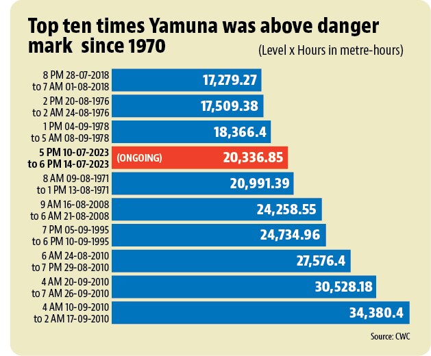
 The current flood is one of the worst in Delhi’s historyThe 2023 flood in Yamuna is far from over. Yet it has already broken some records. It broke the record for the highest ever level the river has reached in Delhi -- 208.66 metres on July 13. To be sure, this level was recorded in only three readings taken hourly from 6 PM to 8 PM. If one were to multiply the level maintained by the time for which it was maintained for all of the sixty times Yamuna has crossed the danger mark since 1970 in Delhi, the 2023 flood is ranked seventh highest so far, a rank that this flood is likely to better before it is over. The level-hour product for Yamuna was 20,3367 metre-hours as of 6 PM on July 14. This number was 20,991 metre-hours for the sixth ranked flood (August 1971) and 34,380 metre-hours for the highest ranked flood by this metric (September 2010).
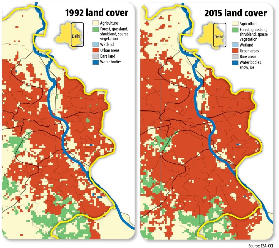
- And concretisation close to the Yamuna has a role to play in thisThe 2023 flood lasting for very long is not an isolated event. As HT explained on July 13, the Yamuna now reaches higher levels than in the past when it goes past the danger mark; and it stays above the danger mark for longer. A possible reason for this – apart from climatic factors such as rains intensifying in the upstream states – is the concretisation of the area close the river. Concrete close to the river prevents water from being absorbed by the ground when the river overflows. Therefore, it is likely to be one of the factors in Yamuna remaining above the danger mark for longer. Land cover maps from the European Space Agency’s Climate Change Initiative (ESA-CCI) show that urban areas have crept closer to the Yamuna in Delhi over time.
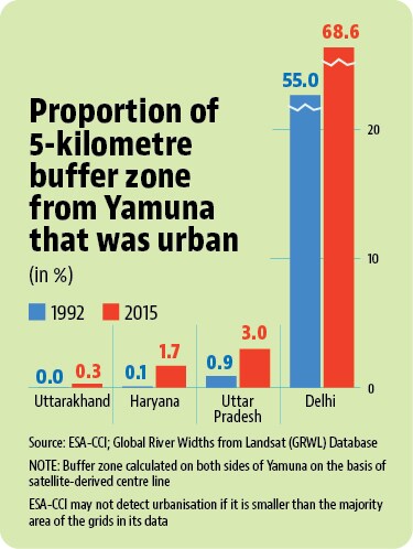
- However, urbanisation close to the Yamuna is not limited to DelhiWhile it is Delhi that is facing floods from the Yamuna currently, it is not the case that only Delhi has brought concrete closer to the river. HT created a buffer zone of five kilometres on either side of the Yamuna’s path by using a satellite-derived worldwide database of rivers and lakes (none of them are named in the database) created by scientists George H Allen and Tamlin M Pavlesky. It then checked the changes in urban areas in this buffer zone from 1992 to 2015. The analysis shows rapid urbanisation in the past couple of decades in this buffer zone along the river from Uttarakhand to Uttar Pradesh . While half of this buffer zone was already urban in Delhi in 1992, it has now increased to more than two-thirds of the area. In other states, the urban areas were less than a percent of the buffer zone in 1992, but have since increased very fast: 22 times in Haryana, 3.3 times in Uttar Pradesh, and from 0% to 0.3% in Uttarakhand. This urbanisation upstream and downstream from Delhi also has a role to play in Delhi floods. If the water could get absorbed in the floodplains along the banks more readily, both Delhi and the other states through which Yamuna passes would face a smaller risk of floods.