E-Paper



Number Theory: An unusually warm start to winter in several states
A strong El Niño prevailing currently means that this warming is likely to continue
Published on: Dec 18, 2023, 10:51:05 IST


Share via


Copy link

Temperatures across India have started decreasing with the start of the winter season, which officially runs from December to February. However, an HT analysis shows that the season has been unusually warm so far compared to previous winters, at least by minimum temperatures. While the reason for this warm beginning to winter is unseasonal rain in parts of the country due to Cyclone Michaung in the first week of December, a strong El Niño prevailing currently means that this warming is likely to continue. Here are four charts that explain these trends.
Third warmest start to winter since 1951 despite cooling in second week
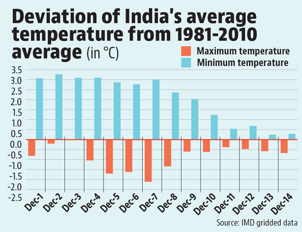
 Third warmest start to winter since 1951 despite cooling in second weekIndia’s average minimum temperature up to December 14 is 14.4 °C. This is 2.04 °C warmer than the 1981-2010 average, considered the normal for temperature in India. This has made the first two weeks of the 2023-24 winter the third warmest since 1951, the first year for which India Meteorological Department (IMD) has published gridded data for temperature. This has happened despite substantial cooling off in the second week of December. The first week of December was 3.03 °C warmer than normal (second warmest since 1951) whereas the second week is “only” 1.06 °C warmer than normal (17th warmest since 1951). A similar gradual cooling also happened in the warmest December month on record (2019) in India. The first two weeks of December 2019 were 3.2 °C warmer than normal on average. However, the month ended up only 2.8 °C warmer than normal. To be sure, the trend in maximum temperatures is opposite to that of minimum temperatures so far. India’s average maximum in the first two weeks of December is 25.5 °C, 0.87 °C cooler than normal and the 11th coolest since 1951. Unlike minimum temperature, India’s average maximum was much cooler than normal in the first week than in the second week.
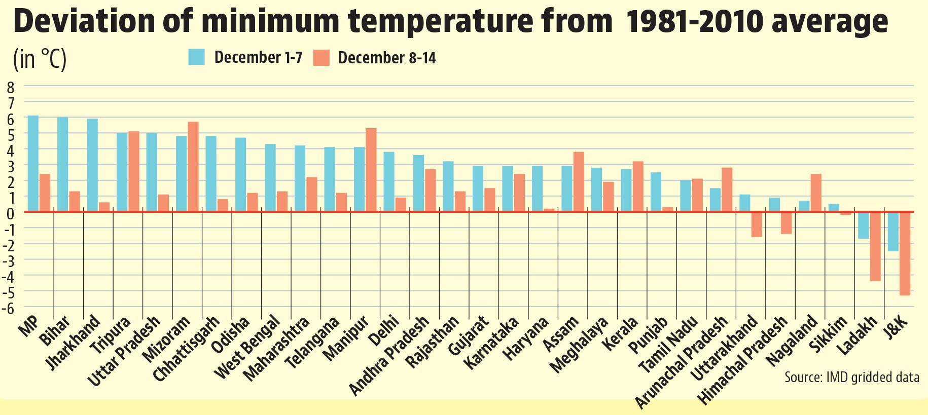
- All states warmer than normal, eastern-central states 3-4 degrees warmer than normalState-wise averages of minimum temperatures show that of the 30 states and union territories (UTs) for which this calculation is possible, only five (Jammu and Kashmir, Ladakh, Uttarakhand, Himachal Pradesh, Sikkim) have experienced almost normal or cooler than normal start to winter. However, a warming in the rest of the country does not mean that they are all experiencing a similar departure from normal. The average minimums in central and eastern states such as Madhya Pradesh, Uttar Pradesh, Bihar, Jharkhand, and Assam are around 3-4 °C warmer than normal. On the other hand, north-western states such as Rajasthan, Punjab, Haryana, and Delhi are only around 1-2 °C warmer than normal overall. A week-wise breakup further shows that the warming has decreased in 20 of 30 states and UTs in the second week of the month, with only southern and north-eastern states becoming warmer.
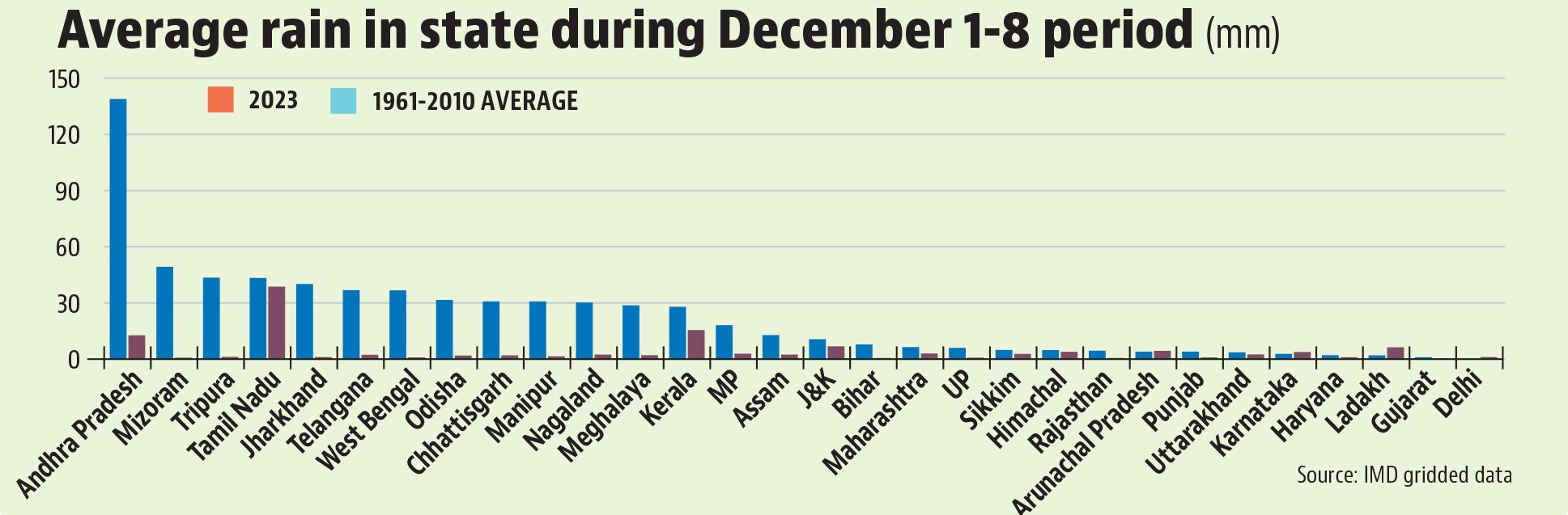
- Rain due to Cyclone Michaung one reason behind warmer than normal minimumsOne reason why minimum temperatures were much warmer than normal in eastern and central states in the first week of December is the un-seasonal rain brought by Cyclone Michaung. Rain tends to increase minimum temperatures because clouds trap outgoing heat at night when minimums are recorded. This seems to have played a role in a warm beginning to winter. While southern states such as Tamil Nadu, Karnataka, Kerala, and parts of Andhra Pradesh and Telangana do receive rain in December because of the northeast monsoon (it runs from October to December), other states usually don’t. However, all big states except Karnataka received surplus rain in the first week of December this year, when Michaung developed into a cyclone and made landfall. As is expected, Andhra Pradesh – where Michaung’s landfall happened – received the most rain in absolute terms in the first week of December: 139 mm. Similarly, there was unusually high rainfall along individual places on the east coast. For example, according to IMD’s gridded dataset, Chennai and neighbouring districts (Thiruvallur and Kancheepuram) received 151 mm rain in the 24 hours ending 8:30 AM on December 4. This is the 19th highest daily rain for any day since January 1, 1901 for these three contiguous districts.
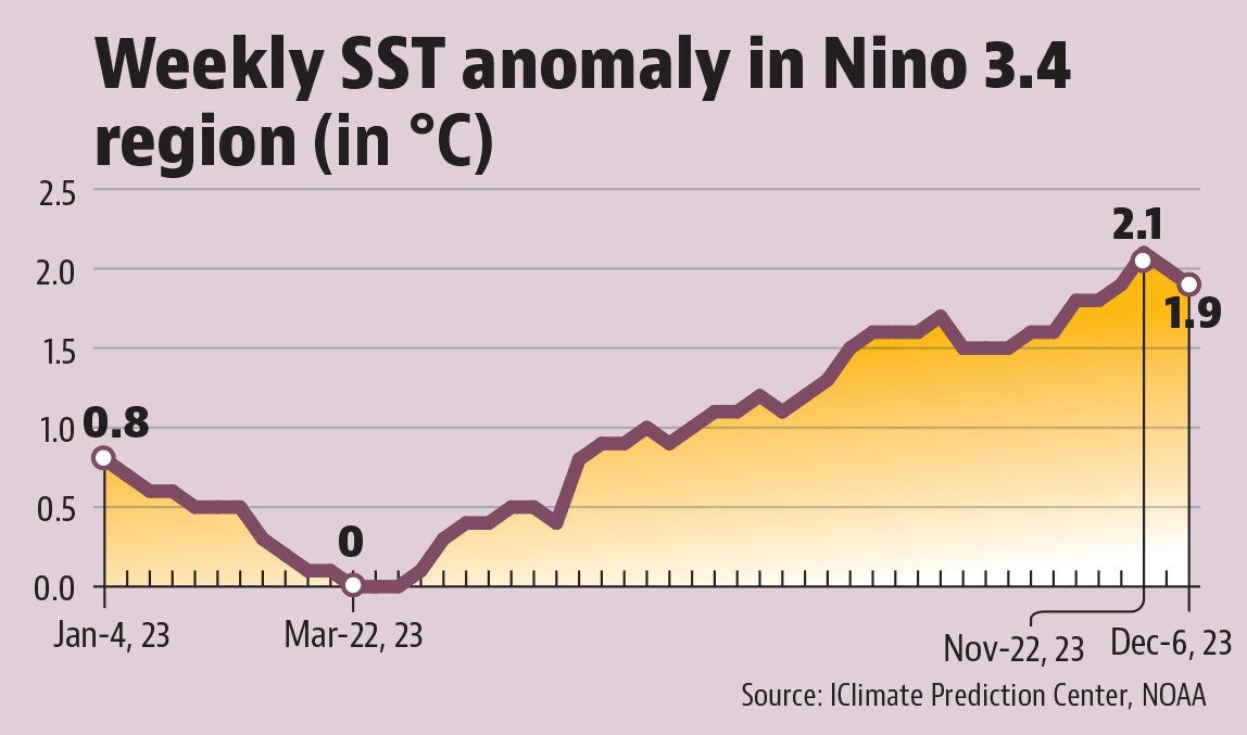
- However, El Niño can keep winters warm even after MichaungWhile warming in minimum temperatures has decreased after Cyclone Michaung, current IMD forecasts show warming in the northern half of the country again in the last week of December. In fact, IMD has forecast a warmer than normal winter as a whole. One big reason for this is the prevailing El Niño situation, which increases global temperatures. El Niño is the periodic warming of the equatorial Pacific Ocean and has been intensifying up to now. In the week ending May 31, sea surface temperatures in the Nino 3.4 region (a part of the Pacific Ocean monitored for El Niño trends) were 0.8 °C warmer than normal. This warming reached a high of 2.1 °C in the week ending November 22 and was 1.9 °C in the week ending December 6. Since most models predict this warming to remain above the threshold 0.5 °C up to the April-June season, its warming effect is likely to be active the entire 2023-24 winter season.