E-Paper



Number Theory: Tamil Nadu is in its most extreme rain spell ever
The extreme rain has only helped bridge its deficit in Tamil Nadu just before the season’s official end

 Prefer HTon Google


Tamil Nadu has been affected by high-intensity rain for the second time this month. The intense rain in early December due to Cyclone Michaung was concentrated in the northern part of the state, and the current spell, caused by a general cyclonic circulation, is in the southern part. An HT analysis, however, shows that it is only the second spell that is officially extreme.

Read here: IMD failed to give timely warning: Tamil Nadu CM Stalin
It has also broken all previous records of extreme rain in Tamil Nadu. Meanwhile, most of the other states that receive rain from the northeast monsoon continue to run a deficit this season. Even for Tamil Nadu, the extreme rain has only helped bridge its deficit just before the season’s official end. Here are four charts that show this.
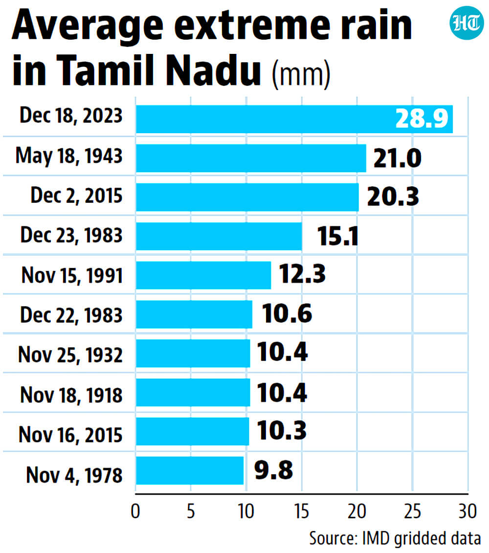
 Highest single-day extreme rain for Tamil Nadu since January 1, 1901The India Meteorological Department (IMD) classifies rain of 244.5 mm rain or more at a weather station in a 24-hour period as extreme rain. Because IMD’s long-term station-wise data is not publicly available, HT has used its gridded data for analysing Tamil Nadu’s rain. Of the state’s 169 grids, 13 received extreme rain on December 18 (the 24 hours ending at 8.30am on that day); On December 4, this number was zero. The gridded data also shows that the state on average received 28.9mm of extreme rain in the 24 hours ending at 8.30am on December 18 – the period used officially for measuring a day’s rain. It is important to understand what this number means – it simply means that on a day when at least one station in the state received extreme rain, the average rain of this kind in the state was 28.9mm. To be sure, the state may have received more rain on a day without any station receiving extreme rain. The 28.9mm is the highest single-day extreme rain for Tamil Nadu since January 1, 1901, the earliest date for which IMD has gridded data. There are only two other days when the state averaged close to this amount of extreme rain. These are May 18, 1943, when it received 21mm of extreme rain on average; and December 2, 2015, when it received 20.3mm of extreme rain. In comparison, the rain on December 4 this year can “only” be classified as heavy (rain between 35.5mm and 244.5mm at a weather station). However, it likely felt like extreme rain. One grid (a grid in IMD’s rainfall data is a box bounded by two latitudes and longitudes 0.25 degrees apart or roughly a square of sides 27 kilometres) between Kancheepuram and Thiruvallur districts received 243.97mm rain on December 4. Similarly, there was no extreme rain in the state on December 19 officially, but one grid came close. A grid in Thoothukkudi district received 221mm rain in the 24 hours ending 8.30am on December 19.
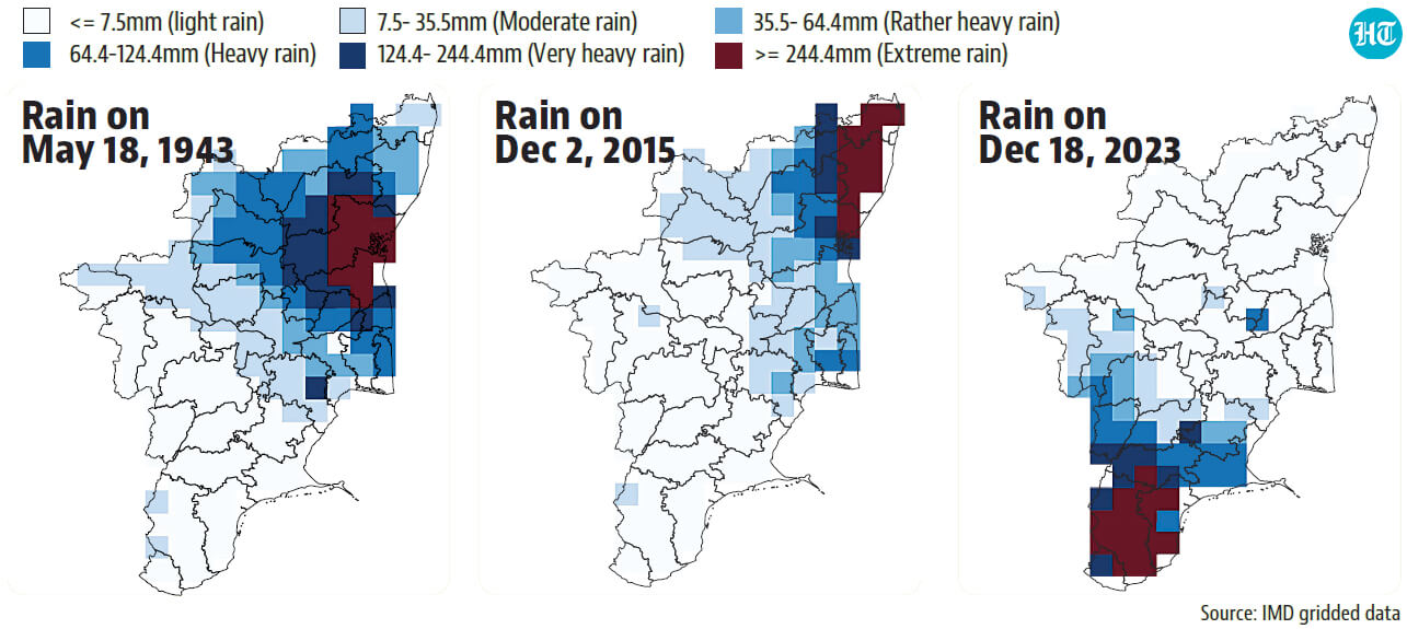
- Among top three instances of extreme rain, this is the only one to hit the southern part of the stateThe December 18 extreme rain in Tamil Nadu is also geographically different from the previous records from 2015 and 1943. In IMD’s gridded data, extreme rain on December 18 was spread over parts of Kanyakumari, Tirunelveli, Thoothukkudi, and Virudunagar districts, all at the southern extreme of the state. In comparison, both the 1943 and 2015 spells were concentrated in the northern part of the state. The current spell was also spread over a somewhat larger area. Of the 169 grids in the state, 13 received extreme rain on December 18, compared to 11 in 1943, and 10 in 2015.
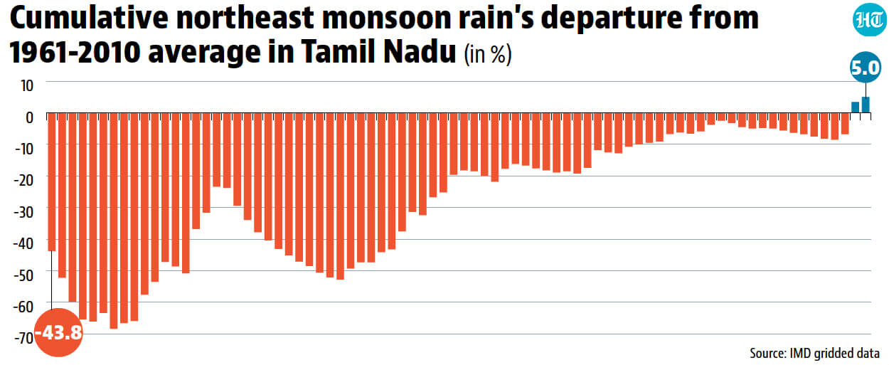
- December 18 rain turned Tamil Nadu’s north-east monsoon deficit to surplus overnightThis is another statistic that highlights how unprecedented the rain on December 18 was in Tamil Nadu. The state receives almost half of its annual rain during the north-east monsoon from October to December. In the ongoing north-east monsoon, the state was running a deficit throughout the season. Although this deficit decreased through most of November and early December, it had been increasing again from December 6. The rain on December 18 has removed the deficit completely. Compared to a 6.8% deficit on December 17 with respect to the 1961-2010 average, a benchmark for rain, Tamil Nadu had a 3.4% surplus on December 18. With heavy rain on December 19, this surplus is now 5%.
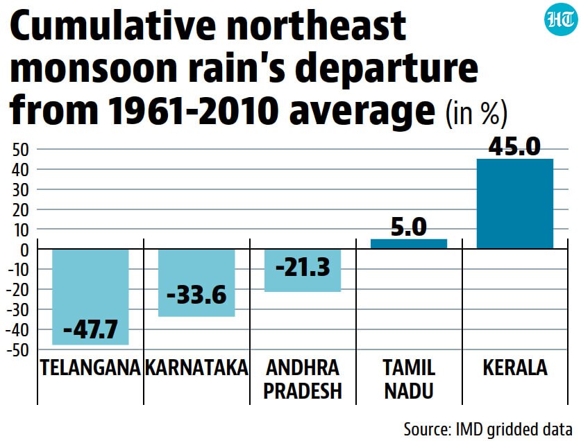
- Despite intense spells, Kerala and Tamil Nadu only states without rain deficit in north-east monsoonThe immediate reason for the extreme rain in southern parts of Tamil Nadu is a cyclonic circulation over Comorin and neighbouring areas. This is a cyclone-like anticlockwise swirling of winds around a low-pressure area. It is, however, a common feature of the north-east monsoon and must not be confused with an actual cyclone. A bigger reason why Tamil Nadu has received two spells of very heavy rain this month could be that both the Indian Ocean Dipole (IOD) and El Nino are active. Both these factors help the northeast monsoon. This was also the case during the 2015 spell of extreme rain in Chennai. To be sure, despite these factors, the north-east monsoon has been dry on average in three of the five states where the season is a significant contributor to annual rain. The five states where the season is important for rain are Tamil Nadu, Andhra Pradesh, Kerala, Karnataka, and Telangana. Only two of these states (Tamil Nadu and Kerala) have a surplus so far. Andhra Pradesh and Telangana have a deficit despite receiving surplus rain due to Cyclone Michaung this month. Karnataka, similarly, has a deficit despite getting surplus rain in November from an Arabian Sea cyclonic circulation.