E-Paper



Number Theory: This winter is a winter of extremes
India’s snow pack has been the lowest in satellite records since 2000-01 on every day starting November 13
Published on: Feb 16, 2024, 18:56:55 IST


Share via


Copy link

India’s official winter season runs from December to February. This means that it will be over in less than two weeks. How has India experienced the 2023-24 winter? HT’s analysis shows that this winter has averaged a warmer than normal minimum temperature and a cooler than normal maximum temperature. This has happened despite temperatures moving closer to normal over the course of the season and wide regional differences. The most alarming thing about this winter, however, is the lack of snow on India’s mountains.

This winter is a winter of extremes
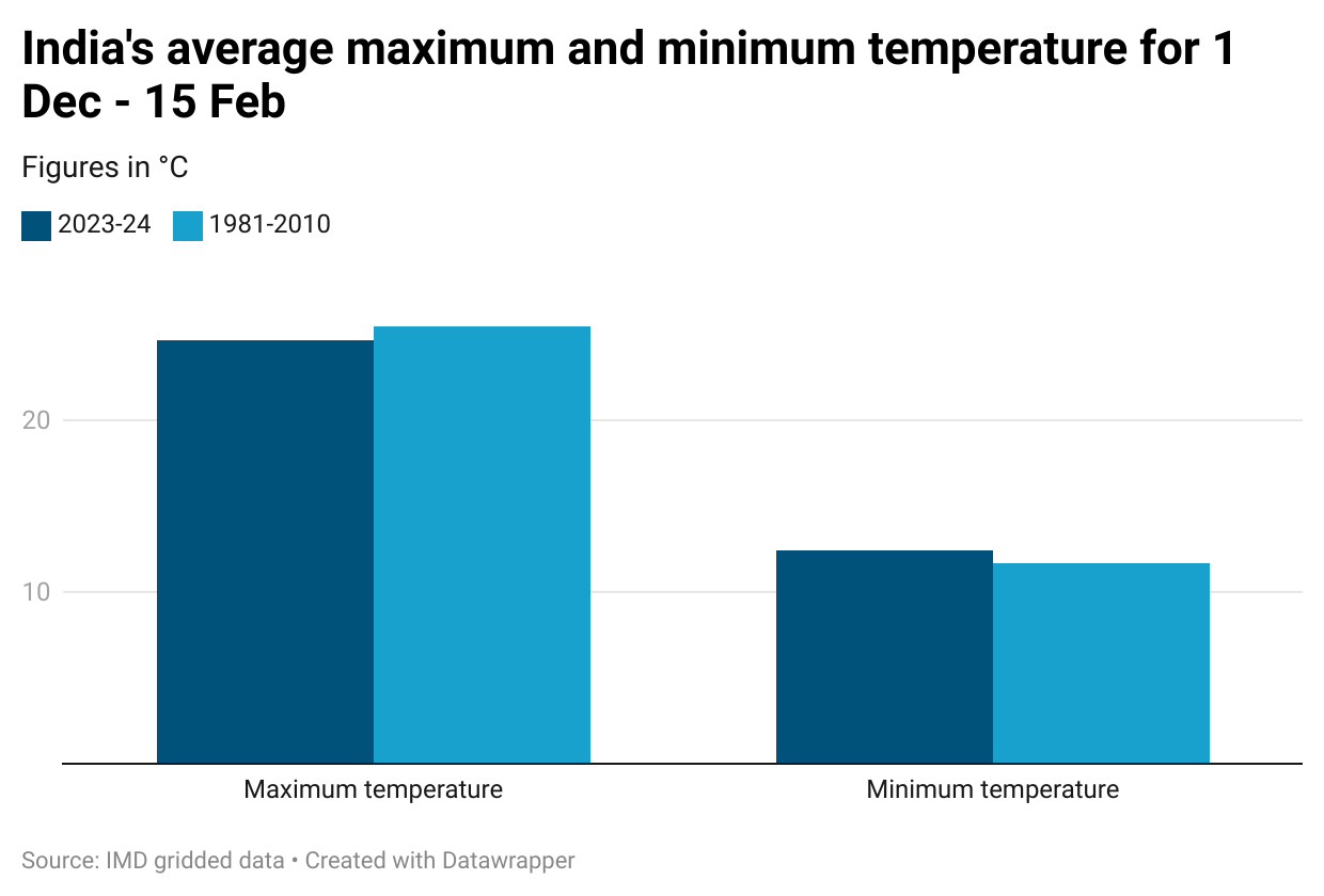
 Seventh coolest by average maximum and eighth warmest by average minimumIndia’s average maximum temperature from December 1 to February 15 is 24.67°C, according to the gridded dataset of the India Meteorological Department (IMD). This is 0.77°C cooler than the 1981-2010 average for this period, considered the normal by IMD, and the seventh coolest since 1951, the first year for which IMD has created gridded data. Minimum temperatures have behaved exactly opposite to maximum temperatures. India’s average minimum for December 1-February 15 period is 12.40°C, 0.75°C warmer than normal and the eighth warmest since 1951.
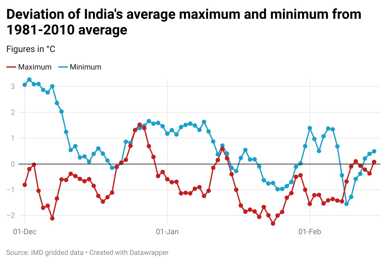
- Both minimum and maximum are closer to normal now than the season average suggestsTo be sure, the extreme trend seen in averages for the season is largely the result of one month of very extreme temperatures: January in the case of maximums and December in the case of minimums. India’s average maximum was 1.08°C cooler than normal and second coolest since 1951 in January. In comparison, December and February so far are 0.44°C and 0.83°C cooler than normal and ranked 16th and 17th coolest respectively. The week ending February 15 was even closer to normal: only 0.18°C cooler than normal. On the other hand, India’s average minimum has moved closer to normal in each successive month of the season. It was 1.36°C warmer than normal in December, but only 0.38°C and 0.28°C warmer than normal in January and February so far. These months of the current winter season are ranked fifth warmest, 24th warmest, and 28th warmest respectively by minimum temperatures.
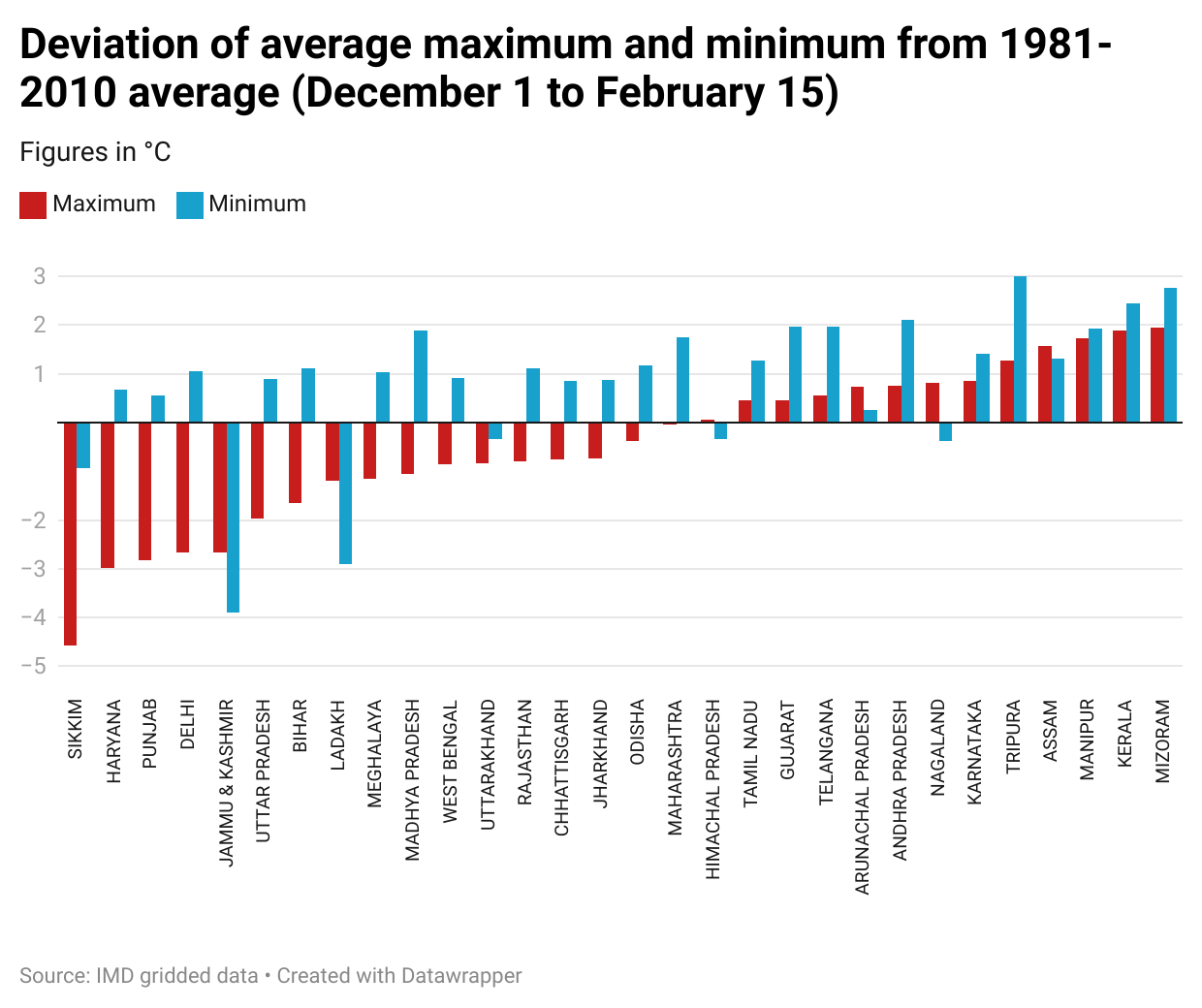
- Wide gulf between northern and southern statesIn keeping with the national trends, the average minimum in most states is warmer than normal for the winter season up to February 15. Only Jammu & Kashmir, Ladakh, Himachal Pradesh, and Uttarakhand in the north and Sikkim and Nagaland in India’s northern-eastern parts have experienced a cooler than normal minimum this winter. However, there is a wide range in other states. The minimums, on average, have been around 1°C warmer or less in most northern states and more than 1°C warmer in the southern states. States are more evenly split in the direction of their deviation from the normal maximum for the season so far. Of the 30 states for which this calculation is possible using IMD’s gridded data, 17 have experienced a cooler than normal maximum and 13 have experienced a warmer than normal maximum. The northern states largely belong to the former group and the southern states to the latter. For example, the average cooling in Haryana, Punjab, and Delhi is 2.99°C, 2.82°C, and 2.67°C, much more than thrice the national average. On the other hand, Andhra Pradesh, Karnataka, and Kerala are 0.75°C, 0.86°C, and 1.89°C warmer than normal.
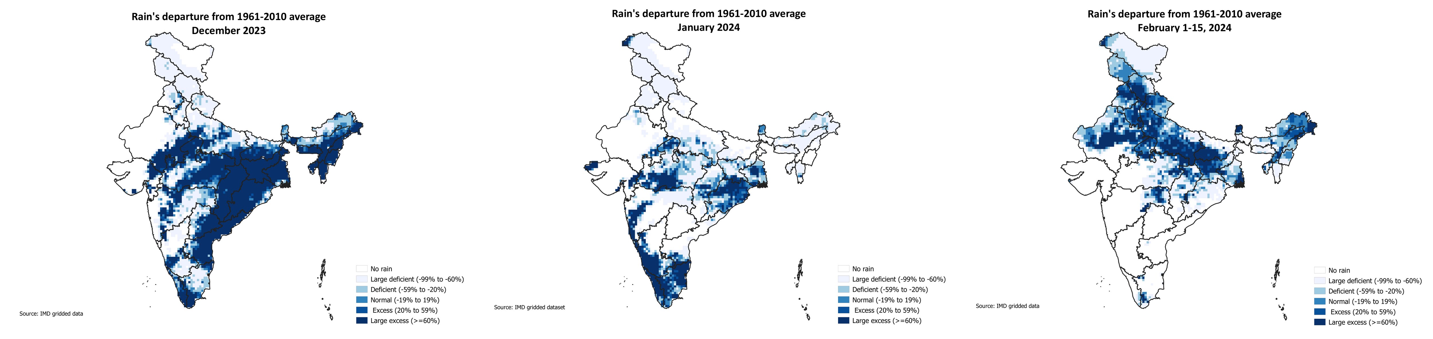
- Lack of strong western disturbances explains these temperature trendsThe immediate reason for the trends prevailing in temperatures this winter season is the lack of strong western disturbances reaching India. These storms, which generally originate in the Mediterranean region, are responsible for winter rain in northern India. As they have not been as frequent or as strong as they should be, most of the winter season has been very dry for northern states. India overall received 25.17mm rain in December, 58% more than the 1961-2010 average for the month, a benchmark for rain. However, in January and February so far, India has received just 7.2mm and 8.3mm rain, 55% and 21% less than the 1961-2010 average for these periods. To be sure, even the surplus rain in December was not on account of northwestern and northern states, which remained largely dry that month in the absence of strong western disturbances. Western disturbances brought some rain and snow towards the end of January, but that may be a case of too little too late.
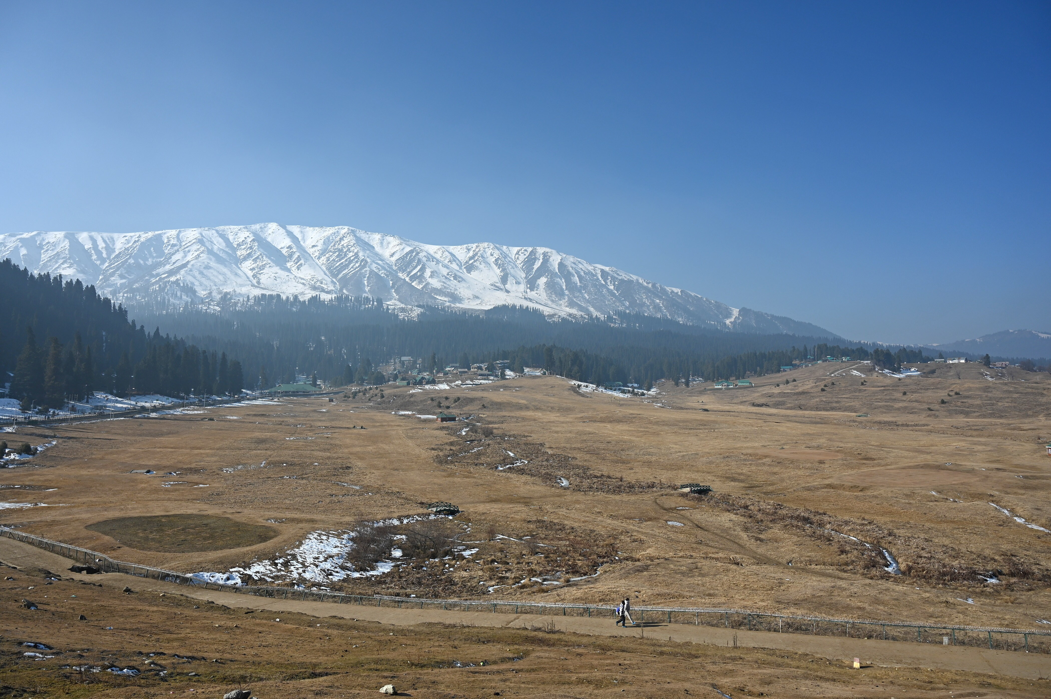
- Dry winter in the mountains does not bode well for the seasons aheadOne big way in which this dry winter has hurt India is by depleting its snow pack. India’s snow pack has been the lowest in satellite records since 2000-01 on every day starting November 13. While the snowfall towards the end of January decreased the deficit (with respect to the average snow pack for the 2000-01 to 2019-20 period), this has not been enough. The deficit decreased from 24.9% on January 27 to 22% on February 4, but increased again to 25% by February 14, the latest day for which this data is available from Nasa. This might affect the snowmelt available to India’s rivers in the warmer seasons ahead.