
 E-Paper



Kerala floods: The impact of the climate crisis on India’s vulnerable ecology
Several experts believe that Kerala’s topography, combined with extreme rainfall events in a short period and unsuitable land use makes the perfect recipe for disaster

 Prefer HTon Google


New Delhi: Kerala saw three devastating floods in four years that together killed at least 600 people and wiped out entire habitations, drawing the world’s attention to how the climate crisis is impacting ecologically vulnerable parts of India.
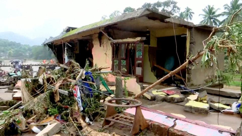
A World Meteorological Organization report highlighted that extreme floods in Kerala in 2018 led to total economic losses of $4.3 billion, the displacement of 1.4 million people, and 5.4 million people being affected in some way in 2018.
Though an economic estimate of the cumulative economic impact of three flood years — 2018, 2019, and now, 2021 — hasn’t been made, it has been an overwhelming blow to infrastructure and livelihoods in the state which continues to reel under the Covid-19 pandemic.
What happened on October 16?
Peninsular India was recording widespread rains since October 11 even before flooding was triggered in some districts of Kerala on October 16. In September, south peninsular India recorded 21.6% excess rains.
On October 14, the India Meteorological Department (IMD) warned that two low-pressure areas — one over east-central and the adjoining southeast Arabian Sea, and another over the central Bay of Bengal (BoB) — formed, which would bring heavy rain to Kerala, Tamil Nadu, coastal and south interior Karnataka, along with Andhra Pradesh, Odisha and West Bengal on the east coast.
“Though on two different sides, these low-pressure systems influenced circulation patterns. The system over BoB helped strengthen the winds along the Arabian Sea. It also influenced the movement of the low-pressure area over the Arabian Sea, which came very close to the Kerala coast and interacted with the hilly regions, bringing a lot of rain in certain parts. We cannot comment on how the rain triggered landslides, but rainfall amounts were very high,” explained K Sathi Devi, head of the National Weather Forecasting Centre.
Between October 16 and the morning of October 17, Idukki recorded 31 centimetres (cm) of rain, Kottayam — 27 cm, Thrissur and Kollam — 17 cm, Kozhikode — 15 cm, Kannur and Pathanamthitta — 14 cm. With already high water levels in reservoirs, rivers and streams may have overflown due to a sudden increase in rain on October 16.
“While BoB low-pressure system moved west northwestwards across north coastal Andhra Pradesh and south Odisha coast, the Arabian Sea system moved east southeastwards and finally the BoB low-pressure system moved towards Telangana and the Arabian Sea system reached Kerala coast on October 16. There was maximum rainfall activity over Kerala compared to other states. This low-pressure system led to the strengthening of monsoon westerly winds near the Kerala coast, which interacted with ghat areas resulting in heavy to extremely heavy rainfall over Kerala specially Idukki, Kollam, and Ernakulam districts experienced extremely heavy rain,” explained M Mohapatra, director-general, IMD.
Kerala: Vulnerable to climate disasters
The elevation in Kerala ranges from -48 metres (m) below sea level in the backwaters and other low-lying areas, to +2,692 m in the hills above the mean sea level. Around 35% of the area is between 0-50m, 39.82% of the area is between 50-500 m, and 24% of the area is above 500m, making its topography vulnerable, according to a presentation made by KJ Ramesh, former director-general of IMD based on data from National Remote Sensing Centre in 2018.
Several experts believe that Kerala’s topography, combined with extreme rainfall events in a short period and unsuitable land use makes the perfect recipe for disaster.
Interestingly, the monsoon rain has weakened over Kerala, and the state has witnessed a significant drying trend in recent years.
According to Assessment of Climate Change over the Indian Region, a report by the ministry of earth sciences published last year, as compared to 1901–1975, rainfall has reduced by 1–5 mm/day during 1976–2015 over central parts of India (the core monsoon zone), Kerala, and extreme northeastern parts, and has increased over the Jammu and Kashmir region as well as in parts of western India.
Central India, Kerala, some regions of the south peninsula, along with the northeastern parts of India, also experienced a higher annual frequency of droughts, with more than two droughts per decade on average from 1951–2016, the report added.
Despite the weakening of monsoon circulation, there has been a threefold rise in extreme rain events over central India and the Western Ghats, including parts of Kerala, according to a study led by Roxy Mathew Koll and his team at the Indian Institute of Tropical Meteorology (IITM) published in Nature in 2017. This concluded that the threefold rise in extreme rain along the west coast and central India was recorded from 1950 to 2015.
“Changes in the monsoon winds are reflected well in Kerala, due to its proximity to the Arabian Sea. The moisture carrying monsoon winds interact with the mountainous topography of Kerala, resulting in orographic rainfall. Rainfall data since 1950 shows that the frequency of extreme rainfall events has increased over Kerala, particular for the central hilly regions of the Idukki, Kottayam and Pathanamthitta districts. Here, the total rainfall during the monsoon season has decreased, but the number of heavy rains has increased. There is a clear climate crisis signal because, as the temperature rises, the moisture-holding capacity of the air increases. Hence, it does not rain for a long period, and when it rains, it dumps all the moisture in a short spell,” explained Roxy Mathew Koll, a climate scientist at IITM, Pune.
“The landslides and floods are not solely due to heavy rains. Often, we are quick to blame the climate crisis. However, we need to realise that roughly half of Kerala is hills and mountainous regions, where the slope is more than 20 degrees. These places are, hence, prone to landslides. When we have land-use changes and development such as quarrying, roads, construction, and deforestation in these regions, the vulnerability of these hills increases. Hence, when heavy rains lash on these hills, landslides happen quickly. This is a situation where the impact of both climate change and direct human intervention in terms of land-use changes are manifesting as landslides and floods,” he added.
These extreme rain events interact with the topography. This mechanism was seen during all three floods in the past four years. IMD, in its report on the 2018 Kerala floods, said that the landslides and floods “can be attributed to [the] consecutive formation (within seven days) of the low pressure system on August 6 and 13 morning. Further both these low-pressure systems intensified into depression and moved west-northwestwards along the monsoon trough. It led to [the] strengthening of westerly-southwesterly winds along and off Kerala coasts as the cross-equatorial monsoon flow increased towards the region of low-pressure system. These stronger winds interacted with the Western Ghats leading to [the] orographic uplifting of moist air.”
This led to the development of clouds, and, hence, heavy rainfall. This year too, the strong westerly winds from the Arabian Sea interacted with the ghat regions to bring unprecedented amounts of rain during a short time.
“Kerala gets good rains during monsoons, over 300 cm annually. Over 10% of Kerala’s land is coastal, and the easternmost part is mostly a hilly region. Almost 50% of Kerala’s land is hilly or ghat dominated. Geographically, this makes Kerala extremely vulnerable. So, when the monsoon is very active, or a low-pressure area develops, there can be very heavy rain over the ghat regions because of the interaction of winds from the Arabian Sea with the hill regions. In August and September, when this happens, the rivers and reservoirs are already full, and start overflowing, triggering mudslides and landslides. This year, the monsoon was very active in September, leading to full rivers and then, once again, low-pressure areas developed in October resulting in floods,” explained DS Pai, scientist and head of climate research and services, IMD Pune.
He highlighted that “heavy rain in monsoon is not a surprise for Kerala. My understanding is that extreme rainfall induced by the climate crisis is exacerbated by land-use change in Kerala. Kerala has one of the highest population densities and people are inhabiting ghat areas. They are doing agriculture and monocultures there which has a big impact in triggering severe disasters like we are seeing.”
“This is a combination of the global climate crisis and local, undesirable changes in land use in Kerala and the entire Western Ghats. Illegal store quarries, for example, all along the Western Ghats are causing severe localised aerosol loading which leads to fluctuation in rainfall patterns. For example, rainfall that may have occurred over 5-6 hours can occur in half an hour in some areas. In Ratnagiri, we saw devastating floods this monsoon which is also very clearly linked to land-use change. There is photographic evidence to show road construction works through hills triggered landslides in Konkan. So today, what Kerala is experiencing is a result of global climate change and local extremely undesirable land use planning,” said Madhav Gadgil, chairman of the Western Ghats Ecology Expert Panel and veteran ecologist.
Kerala has to brace for another climate crisis impact — the rise in sea level. The Indian Ocean, which includes the Arabian Sea and the Bay of Bengal, has warmed faster than the global average, said the Intergovernmental Panel on Climate Change (IPCC) with “very high confidence” in its Physical Science Basis report released in August.
IPCC’s oceans factsheet indicates that sea surface temperature over the Indian Ocean is likely to increase by 1 to 2 degrees C (°C) when there is 1.5°C to 2°C global warming.
“About 50% of the sea level rise is due to the thermal expansion. Also, the Indian Ocean region is warming at a higher rate that means the relative sea level can also increase over the regions. Hence, the coastal regions in India will see the sea level rise through the 21st century, and it will contribute to more frequent and severe coastal flooding in low level areas and coastal erosion. Along with this, extreme sea level events that were previously seen once in a hundred years, could also happen every year by the end of the century,” Swapna Panickal, IPCC author and climate scientist from IITM explained in August.
Lack of land-use planning
The Western Ghats are an extremely ecologically fragile region. The Madhav Gadgil Committee (Western Ghats Ecology Expert Panel or WGEEP) in 2010 recommended that 75% of the 129,037 sq km of the area (spanning Gujarat, Kerala, Maharashtra, Karnataka, and Goa) be declared an environmentally sensitive area (ESA) because of its dense, rich forest cover, and a large number of endemic species.
WGEEP advocated a graded or layered approach within the broad framework of ESZ1 (environmentally sensitive zone), ESZ2 and ESZ3.
Later, a panel headed by K Kasturirangan, the former Indian Space Research Organisation (ISRO) chief, scaled it down to 50%. The Gadgil committee categorised several areas in ghat regions of Kerala as ESZ 1 —of highest priority where no monocultures, mining, quarrying, no new polluting industry can be allowed, among other restrictions.
Neither of the two reports has been implemented yet. A senior official of the Union environment ministry said, on condition of anonymity, in August that “states had various reservations with the recommendations. And because of the Covid-19 pandemic, we have sought time till December 31 to declare ESAs in the Western Ghats, so we have time to discuss and resolve the differences with the Western Ghat states.”
“The Western Ghats are the perfect storm because of coastal areas vulnerable to any activity in the Arabian sea, being ecologically sensitive and significant, and then there is the land-use that is far from optimal, to say nothing of the unequal patterns of ad-hoc development. We cannot be responding to each event as a standalone. These events are happening all too often and usually in tandem with other stressors such as what’s happening with Covid-19 or for many people, existing stresses of poverty and inequality. The Sendai Framework for disaster risk reduction also suggests that we adopt a more pre-emptive strategy to dealing with disasters rather than after the fact. What’s compounding the issue in the Western Ghats is the planning and land-use activity that hasn’t fully taken into account suggestions by the Gadgil committee. One of the key aspects of that report was to consult with local bodies and Panchayats on any development activities in the region,” said Smitha Rao, a faculty member at The Ohio State University who specialises in disasters and environmental justice.



